Total Distance: 15 km
Return Time: 5.5 hours
Elevation Gain: 853 m
Difficulty: Moderate
Region: Carcross
Traditional Territory: CTFN
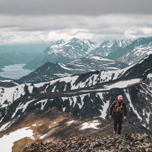
The Montana plateau is a great area to explore, and Montana Mountain is the highest peak on the Montana massif. It isn't a difficult hike, but you need a vehicle with a little bit of clearance (even a car that doesn't sit too low is fine). Most of the hike is above the tree line and the views are always pleasant. The view from the summit and the ridge are fantastic, opening up an ocean of mountain tops in all directions. NOTE: This hike falls within Category A Settlement Lands of the Carcross Tagish First Nation. Please respect their rules and land.
From Carcross, drive south on the South Klondike Highway across the bridge and take your first right. Take the next left up a gravel road. Continue straight up, you're on the Montana Mountain Road. The condition of the road varies depending on recent maintenance work and road use. Note the area has a big mountain biking trail network so make sure to share the road.
Drive for about 8 km on the Montana Mountain Road. There was a smaller washout around here that you may or may not be able to cross. There is a landslide at KM 10 that is impassable by vehicle, and this will be considered the trailhead.
Please Note: that the Montana Mountain area is within critical post-calving habitat for the Carcross Caribou Herd of the Southern Lakes Region. If you come across any caribou (or other wildlife for that matter), always keep your distance, giving all wildlife a wide berth, and keep any dogs on leashes or leave them at home... they won't know what they are missing!
From the trailhead at KM 10, you will have to cross the landslide. The landslide cuts across at a fairly steep angle and the small rocks are loose and will slide down as you walk across, but it is not overly difficult. You can walk up and around the landslide through the bushes, but this will take a little longer and the bank is steep.
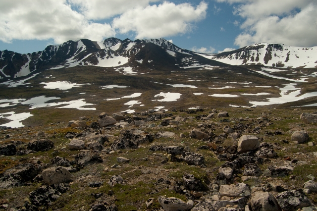
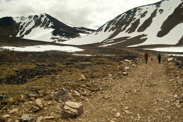
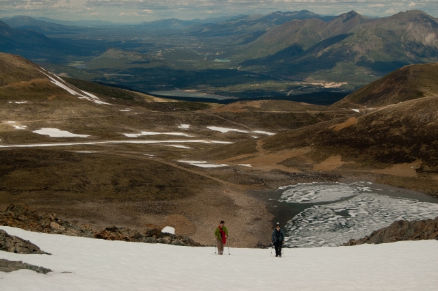
Continue walking up the road for another 2.5 km where you will reach a fork in the road and come to an open plateau. Montana Mountain is directly in front of you. Take the road to the right and either follow it as it winds it's way to the mountain, or walk across the plateau and intersect the road.
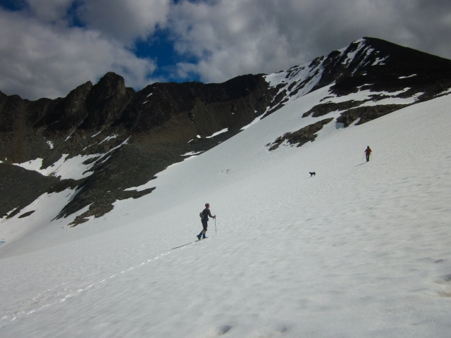
After about 2 kms after the fork in the road, you have a choice of how to climb up the mountain. You can either take the ridge on the far right and walk along the ridge to the summit, or you can walk straight ahead and climb up the couloir to the saddle between the ridge and the summit. Both options are fairly easy, the ridge being a longer scenic route and the couloir a more direct, steeper route. If there is snow in the couloir, it can be easier than walking up scree rock on the ridge (and you can slide down it on the descent). If you can't decide, then do a loop by going up one way and coming down the other.
To get to the couloir, walk up the road towards the ridge to your left (this ridge has a formidable black, rocky peak on it). There is a small tarn below the ridge cirque. The couloir is straight up from this alpine tarn. If there is still snow in the couloir, cut up it at an angle on the first steep section, and then just walk straight up to the saddle below the summit. It is a quick scramble up to the summit from the saddle.
If you want to walk along the ridge, follow the road leading to the right-most ridge. Once on the top you can easily walk along it (and the worn-out sheep trail) towards the saddle below the summit.
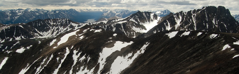
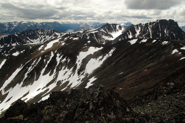
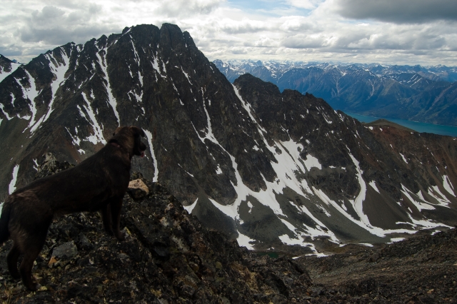
From the summit, you get a 360 degree view of the area. You can see Grey Mountain near Whitehorse, Mount Skukum on the Annie Lake road, Bennett Lake, Tutshi Lake, Tagish Lake, and all the way down the White Pass and Chilkoot area.
There is a repeater station further down on the Montana ridge which you can walk to if you wish (note that the repeater is not on the true summit). The mountain behind Montana (southeast) with the steep rock face is Mount Matheson. Looking back towards Carcross (north) slightly to the left (northeast) is Brute Mountain. The hill slightly to the right (northwest) in the same direction is Sugarloaf Hill.
If attempting this route in the winter, be sure to checkout the Yukon Avalanche Association website for their 'Avalanche Terrain Ratings' Maps - ATES (yukonavalanche.ca/ates). They have mapped this area. The road travels through mostly 'simple' avalanche terrain until the near the lake below Montana Mountain itself. To gain the peak you would be entering 'challenging' and 'complex' terrain with more avalanche risk.

After you park, your first obstacle is the landslide.
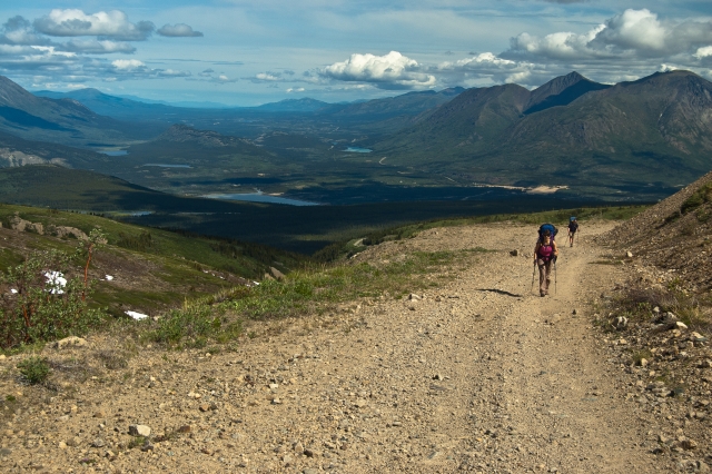
The road is pretty easy going and is above the trees.
Montana Mountain from the fork in the road. The summit is direct center. The saddle and couloir are slightly to the right and the ridge is on the far right.
Walking on the road to the left with the colouir and summit in the background.
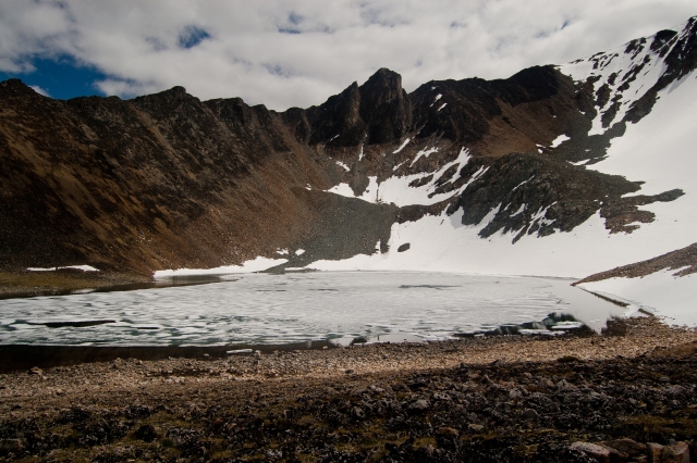
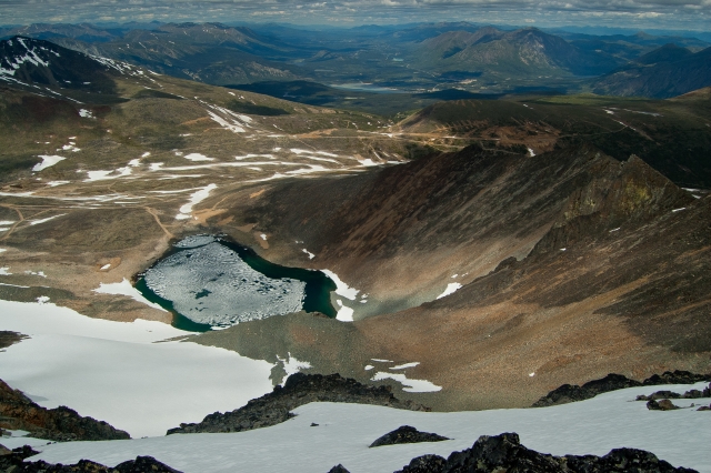
The tarn, surrounded by a cirque with a rocky, black knob jutting out of it.
Heading up the couloir. The summit is on the far right.
Looking down the couloir with a view all the way back to Whitehorse.
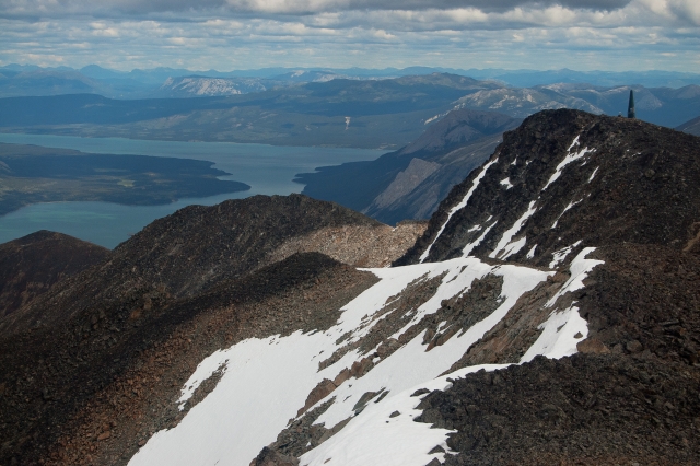
A view behind Montana Mountain from the saddle. Tutshi Lake is way at the back and Mount Matheson is on the right.

A view to the east from the saddle. There is a tram-line and more mining roads down on the plateau.
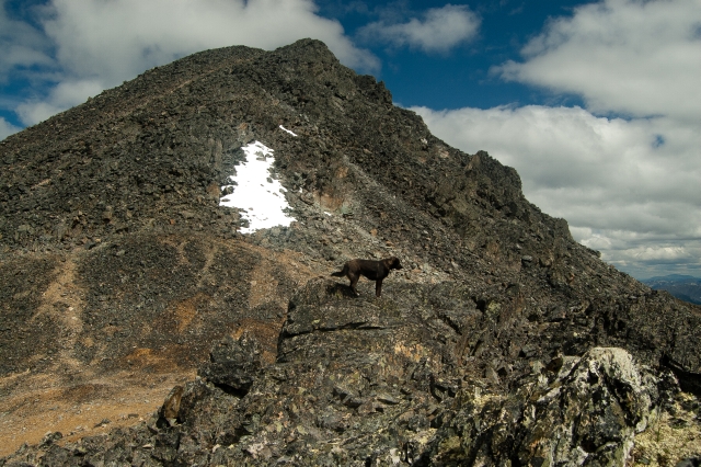
The black summit of Montana Mountain. You can follow a worn-out trail up, or just scramble as you please.
Looking down (north) from the summit back towards the road.
Looking east from the summit towards Windy Arm of Tagish Lake. There is a repeater along this ridge.
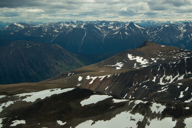
The southeast view from the summit with Dail Peak on the upper right (connected to the same plateau as Montana Mountain).
The steep, rocky face of Mount Matheson.
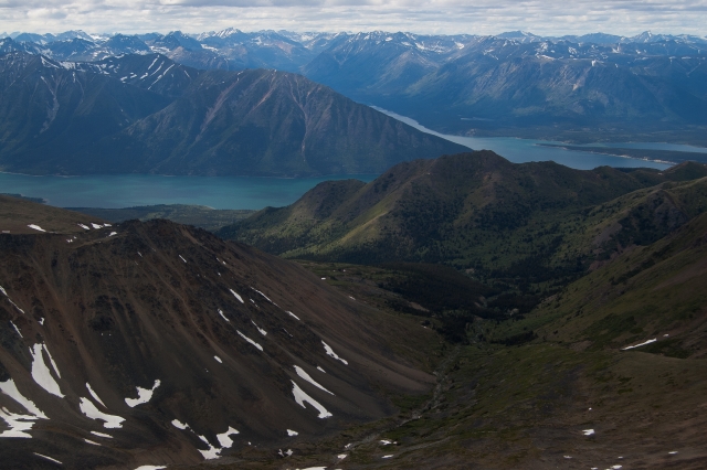
If you take the ridge route, you get a view of the valley between Montana Mountain and Mount Matheson with Bennett Lake at the end.
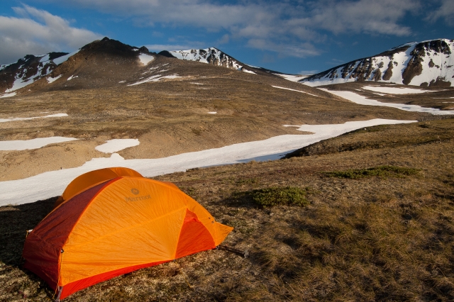
There are plenty of spots to pitch a tent on the Montana plateau.

Murray Lundberg March 9, 2026
If a detailed history of the Montana Mountain mines interests you, I've put my 1996 book "Fractured Veins & Broken Dreams" online for free reading/download - it's in the EMR Library at https://emrlibrary.gov.yk.ca/ebooks/fractured-veins-and-broken-dreams.pdf

Yukon Hiking September 16, 2025
CLOSURE NOTICE! Alpine Trail Access Closed Due to Bear Incident
Please be advised that there has been a bear incident on Montana Mountain, and there is reason to believe the bear may be injured.
C/TFN has requested that users avoid all trails accessing the alpine until Guardians and Conservation Officers can assess the situation. In the interests of public safety, the following trails/routes are temporarily closed:
• Access to the Mountain Hero Trail
• The Mountain Hero Trail itself
• The Brute Mountain and Sam McGee routes (as described in Yukon Hiking)
We also ask all trail users to exercise extreme caution on all other trails and to follow these important safety tips:
• Keep pets leashed at all times
• Carry bear spray and know how to use it
• Travel in groups and make noise
• Report any further sightings to Carcross RCMP
Dacvan August 6, 2024
I now have an up-to-date report for Ted Tucci. The trail description above is accurate with respect to the vehicle. I drove a truck, but a sturdy SUV like a forester or RAV4 should have no problem and good weather. Pretty sure that most cars and trucks would not be able to pass the 8km washout: I certainly would not have tried. On the hike up, I took the much longer ridge route, rather than the snowy couloir, as I had no ice axe. In retrospect, I should have done the couloir. I wound up descending on it, with a fun long bumslide glissade. At the main road/trail junction, I then proceeded east, and explored the old mind site with its tram rails. I then continued northeast and climbed Sugarloaf Peak (no defined trail), before heading towards the 8K parking lot via the gravel roads east and upslope of the trail described in this write-up. At the intersection just west of a creek, where those roads are closest to the 8km parking lot, I planned to bushwhack down the 300 m are so, but happily I was able to follow the sun light and gravel, and found an old path or Caribou path that let me right back down to the car. A gruelling but perfect day. Thank you, yukonhiking.ca for this great hike description, and for this amazing hiking resource.
Dacvan August 3, 2024
Sorry Ted Tucci: just seeing this, a year later. The road up to around 6KM was a decent logging Road that a sturdy 2WD could do . After that, it got pretty rough. Note: this was last year, August 2023, and may well be very different now.
Ted Tucci August 19, 2023
Dacvan. Just wondering how the road was getting to the washout? Were you able to go it in a regular passenger low clearance car? heard the road was pretty rough after all the rain we've had
Any intel would be great appreciated!
Dacvan August 15, 2023
Thank you for this great route description. We hiked up to the base of the couloir, but turned back as it was getting late and the peak was enveloped in clouds. In retrospect, we should have climbed the ridge route: there was not enough snow between the tarn and the couloir to make that shortcut, easy or particularly safe. One big caution: at approximately 8K on the approach road, the road narrows considerably, with deep dangerous ditches on either side: you only have about 2 inches to spare: much more terrifying than anything on the hike. We shall return!
AW May 30, 2023
hiked this last fall (early september). the hike was great! I believe we took the easier approach following the exploration around the southwest with a lot of switchbacks. The only thing worth mentioning is I found crossing the landslide to be a bit sketchy and I was a bit terrified crossing especially on the way back to the car at the end of a long day and being very tired.
Yukon Hiking August 28, 2022
Hiked this on August 27th. Fall colours are well on their way. When hiking later in the summer, the snow couloir is more of a ice patch with lots of exposed, steep rock around it, so better to take the easier approach following the exploration around the southwest that wraps around and up the south face. Then follow the trail on top of the ridge east, all the way around to the summit. Amazing views all around!
Ehren June 22, 2022
Hiked this Jun 21. Still some snow on the trail past the landslide, but easy enough to go around. Some snow was left on the plateau and up to the summit. To avoid that, we hike the peak to the northeast of Montana Summit instead.
I'd recommend bringing a warm layer for the plateau, it got fairly cold in the wind and hailed on us at one point.
Liz B July 10, 2021
Hiked this in a group of 4 on July 10. We drove up in a Nissan Xterra and JUST made it through the km8 washout (with someone outside the vehicle spotting as it went over the stream) and were able to park at the km10 landslide. Our tires were on the very edges of the washout, I wouldn't even bother trying to get through the washout in a vehicle with a wider wheelbase.
The trail is easy to follow from the landslide all the way up to the summit. We ended up hiking up the far right ridge and hiking (sliding down) the still snow covered couloir. It saved our knees and was quite fun!
Warm layers were a must as we got snowed on and with the winds, temps were definitely below 0 for a portion of the day.
We spotted some sheep over on Brute, and a Wandering Tattler but no other wildlife through the day.
According to our Garmin, we did a total of 15.5km distance and had an elevation gain of 1100m.
We ended up leaving a blue lunchbag on the road just before the landslide so if any kind soul finds it and wants to bring it back to Whitehorse, feel free to shoot me a text 867-336-8081.
Haley August 12, 2018
Found a nice Stanley thermos up by the mines - message me if it's yours! 332-2466
Yukon Hiking July 6, 2017
Please note that the Montana Mountain area is within critical post-calving habitat for the Carcross Caribou Herd of the Southern Lakes Region. If you come across any caribou (or other wildlife for that matter), always keep your distance, giving all wildlife a wide berth, and keep any dogs on leashes or leave them at home... they won't know what they are missing!
Marc June 12, 2016
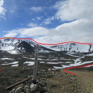
Hiked Montana Mountain on June 10th. I started at around 7 pm, parked my car at the 8 km point, I walked for a few kilometers and ended up at the Mountain Hero bike Trailhead which is at the fork (where my picture was taken). I followed that trail and I was on the summit (green dot) at 11:45 pm watching the sunset! Beautiful hike.
There's about a dozen different trails going in every direction on Montana Plateau, so it would be good to know in advanced WHICH ONE takes you to Montana Mountain? Also, there's about 5 or 6 different peaks that look to be around the same altitude from below, so it's hard to know which one you're supposed to get to... I just assumed this is where I had to go and I still don't know if I took the correct path. I ended up doing a big loop (red line) and continued my way along the ridge to make sure I was going to be on Montana Mountain at one point.
I came back down on one of the ridges after that repeater station on one of the summits. Camped out, came back the next day. For having done Brute Mountain the day before, I would say Montana was way harder (at least, the path I took). But it was also way nicer!
Sean September 17, 2013
Depending on what you've got for a vehicle, you can drive pretty much to the base of the ridge via the road that bypasses the landslide. An ATV or side-by-side would allow you to go right up the old cat road switchbacks on the east ridge and from there it's about a 20 foot walk up onto the ridge to start hiking. Fantastic views in every direction!
Sophie September 8, 2013
Amazing view at the top, worth it! But we found a bit difficult to find our way through the bushes to avoid the landslide, we ended up doing 18K total with this extra walk. Maybe we should have tried to cross the landslide directly, but it was really steep and the rocks were sliding under our feet. The next time we will try the 1905 road in order to get closer from the start in car.
Mike August 17, 2013
I went up a couple of weeks ago and did not see the 1905 road that's apparently marked. I made it to 8km parking where the road is washed out and walked to the landslide. I tried to make it across, but halfway across, it was too dangerous and had to turn back. I was quite disappointed. I'd really like to find the 1905 road...
Sue June 21, 2012
Murray:
Please do. I've been looking for a copy of that book...
Murray Lundberg July 3, 2011
If you have a fairly high-clearance 4x4 (we now use a Chevy Tracker) you can drive many miles further. About a kilometer past the tailings pond (and about a kilometer before the first partial washout of the road being described here), there is a smaller road that goes off to the left - you go through a shallow ditch to access it. This is the original 1905 wagon road, and it can be followed for about 15 miles further, opening up a vast area to day hiking. Some day I'll get my book about the mountain (Fractured Veins & Broken Dreams) back into print - there is an incredible variety of country to see up there.
