Total Distance: 15 km
Return Time: 5.5 hours
Elevation Gain: 1063 m
Difficulty: Difficult
Region: Annie Lake
Traditional Territory: CTFN
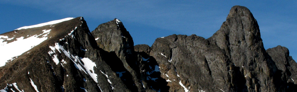
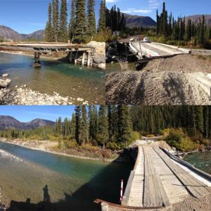
The Mount Skukum area is a Yukon hiker's playground! There are endless opportunities for exploring. Since the two bridges were taken out along the Annie Lake Road, on the Becker Creek and Wheaton River, the area has definitely become less accessible. But once you arrive, it is easy hiking via old exploration mining roads, and the views are rewarding from every angle. Mount Skukum (2,377 m) itself is an impressive volcanic rock complex, and the peak would require rock climbing gear. The hike described here is to a lower peak.
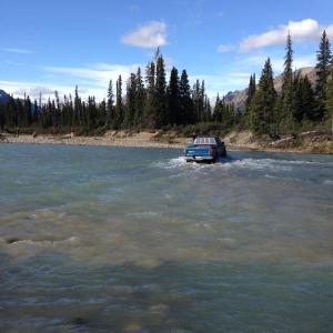
From Whitehorse, drive south on the Alaska Highway to the Carcross Cutoff and turn right onto the South Klondike Highway. Drive south for about 17 km and turn right onto the Annie Lake Road. After 26 km on the Annie Lake Road, you will cross a bridge over the Wheaton River. The road is not maintained after this and is a bit rougher. There have been washouts in the past, requiring a higher clearance vehicle to get around (keep an eye on recent conditions for updates). Around 10.7 km after the bridge, you will reach the first of two water crossings, Becker Creek. After that it is 6.9 km of dirt road until you'll take a right onto a road that leads down to the Wheaton River crossing. This crossing is a lot more substantial, but doable in a 4x4 truck at low water (best timing late summer/early fall when runoff from snow melt is lower).
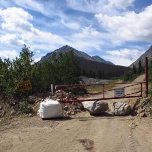
Once across the Wheaton River, drive on the main road for about 200 m and then keep left at the next main road junction. The road is in good condition for about 5.5 km until you reach some old mining gates (that were open as of Summer 2024). Here there are a lot of large rocks and bumps to navigate, keep to the main road to the right of all the rocky piles. After this, drive up the hill and keep right at the next junction (the other one goes to Berney Creek).
You used to be able to drive the road all the way up to the old explosives trailer. But the road has since been washed out and conditions may continue to change. It may best best to park at the last road junction of Berney Creek Road and Skukum Creek Road and hike from here.
Note: The Mount Skukum area used to have an active gold/silver mine from 1986-1988, and mineral exploration continues to this day. There is an abandoned adit past old explosives trailer and the old mill and office remain at the end of the Annie Lake Road (behind a locked gate). Hikers should be cautious around the abandoned adits as these structures are unmaintained and their stability is questionable. Dall's sheep are also see in this area, so please give them a wide berth if you encounter any.
If you parked at the road junction with Berney Creek, continue up the road to the right, which switchbacks up the rocky slope. There are some rockslides you may have to navigate around. The old mining 'explosives' trailer is a good landmark, and this is where the trail begins.
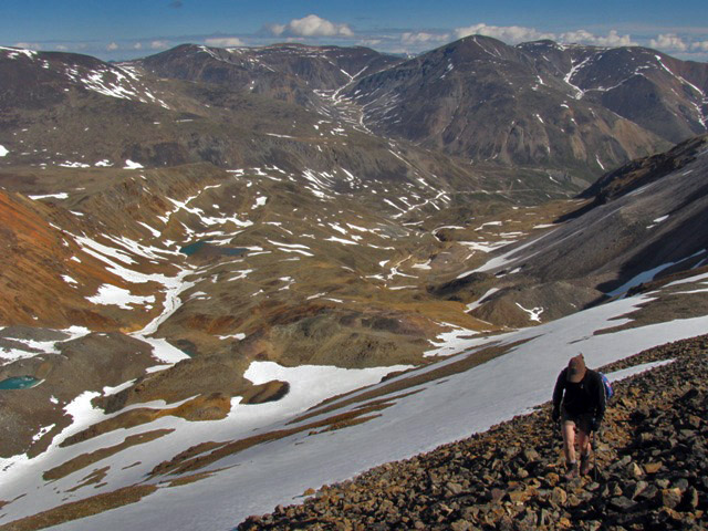
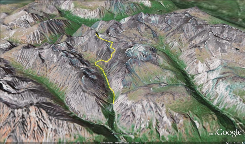
From the parking area follow the rougher exploration road which leads steeply up the valley along the right side of Skukum Creek. You will follow this road for approximately 3.6 km, as it gradually climbs up the valley into the alpine. There is an exploration road spurring off to the right, but continue straight up the main valley.
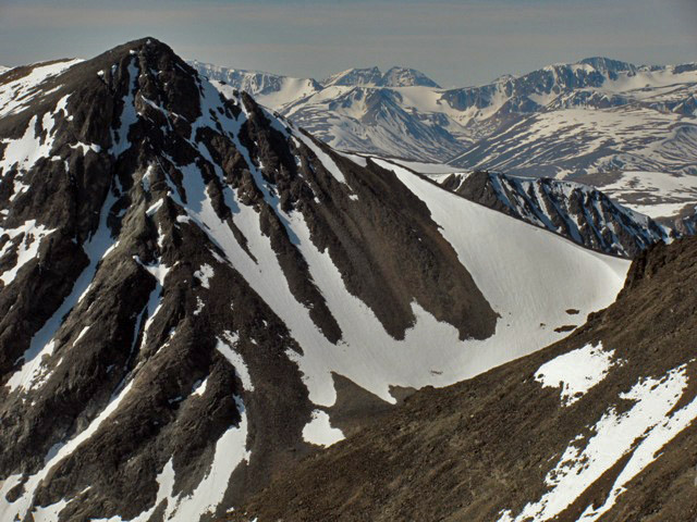
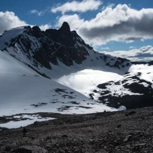
After 3.6 km of hiking on the road, there will be another intersection, with a rocky track leading up the mountain to the right. The track is a lot steeper in places and is on scree for the most part. The track leads up into a bowl and then over a saddle where you get your first look at the granite spire of Mount Skukum as well as a view into the adjacent valley below (where there are numerous other exploration roads and mining remnants).
The route then leaves the exploration road and traverses along the north side of the hill to the left aiming towards the east ridge of Mount Skukum. From this vantage you can see back into the Skukum Creek valley with views of the snowy coast mountains to the south. Follow the narrow ridge up as you begin the final ascent to the top of one of Mount Skukum's lower peaks.
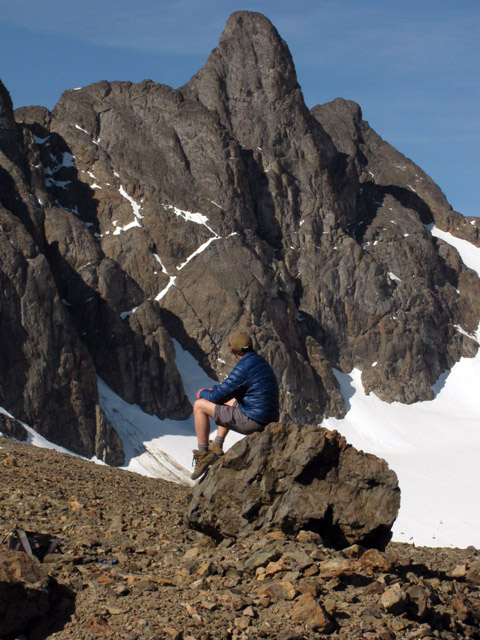
From this peak soak in the views of the area, and admire the volcanic landscape. Be careful around the sheer cliffs surrounding the peak. Depending on your scrambling abilities and head for heights, you can scramble down and up to another sub peak or ridge closer to the true peak. The actual peak of Mount Skukum requires more down climbing and scrambling from the lower peaks and ridges, and then a very steep scramble and rock climb to the top.
Return the way you came.
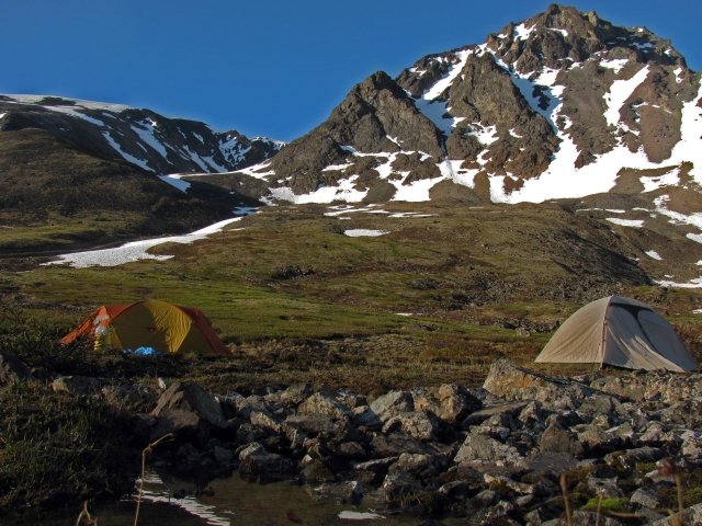
The Mount Skukum Area provides easy access to the alpine for day hikers and overnight campers who wish more time to enjoy the surrounds.
Following the exploration track up from the Mount Skukum trailhead to the saddle.
The first glimpse of Mount Skukum after reaching the saddle.
A view back into the adjacent valley, as we hike towards the ridge.
Views southwest towards the coast mountains.
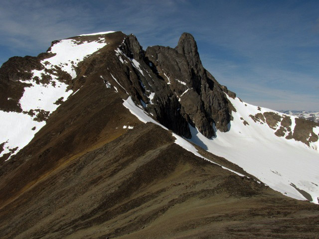
The long ridge to the first lower peak, with the rocky spire of Mount Skukum in the background.
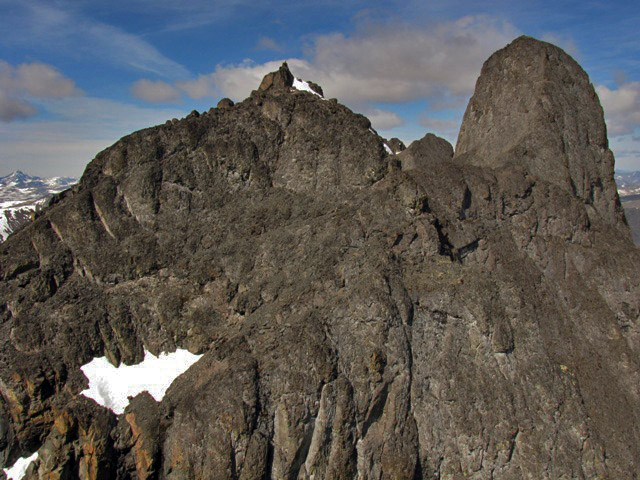
View of Mount Skukum from the lower peak
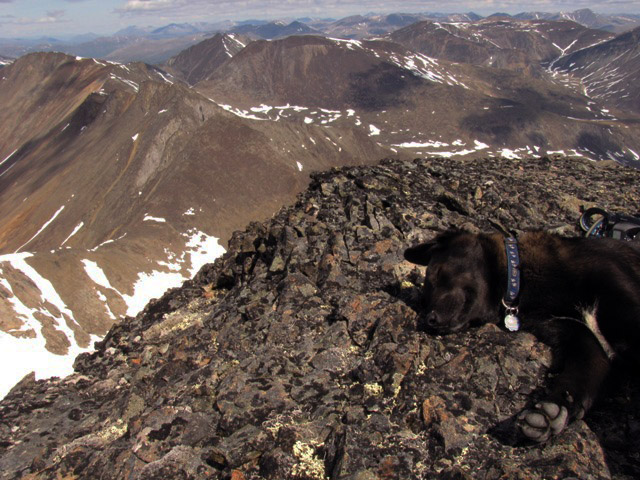
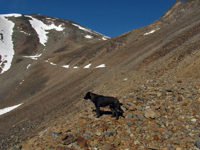
View from the top looking north, and that's one tired dog!
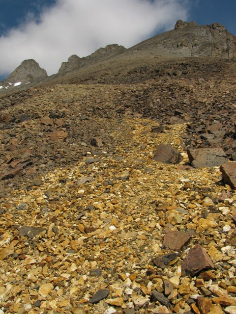
There's gold in them-thar hills!
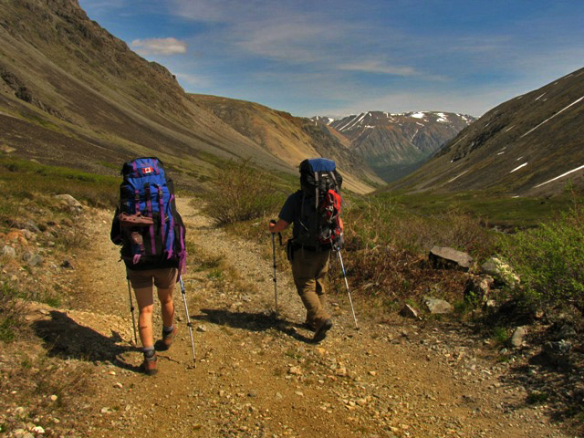
Hiking back down the Skukum Creek valley after a great adventure.
Randi July 18, 2020
I biked in today from where the 35 km bridge is out (river crossing no problem there) but got turned back at the 44 km crossing. The force and height of the water was over my comfort level, especially solo. I did check the spot 100 m down where it’s shallower but the last 1/3 near the opposite shore was too deep and zippy. I’ll be back in August!
D$ July 12, 2020
Climbed to summit yesterday. Climbing via SE ridgeis probably only 5.4-5.6ish if you go direct immediately left of the prominent fin. The climbing is largely unprotected and with lots (!!) of loose rock to navigate. Yuck. Great summit. Great views.
Alice August 14, 2019
The road up into the Skukum creek valley is now blocked shortly after the switchbacks (avalanche?).
Alex K September 11, 2018
The last bridge is being held up by a single post. Probably not for much longer once the spring melt takes it out too. You can cross the bridge right now with an ATV or lighter. Cars need to stick about 100m downstream where the water was only 1 -2 feet deep on 2018/09/10
Wilfred Zaha January 19, 2018
To clarify the bridges. The final brige is out! This is the one at the mine office turn and right before the fencing. You can drive around with a 4x4 truck(would sugest late summer/fall when the water isnt as high). The butte creek road only goes a km or so Unless you have an ATV.You can not drive up the mountian with a full size truck as all the culverts have been removed.and the road is impassable up that creek. I have not explored the south road(towards the tailings) so dont know if that drivable.
Yukon Hiking August 30, 2017
Assume the bridge is still out and that you need to hike/bike across the bridge to get to the trailhead (~8 km one way).
Patti Balsillie August 29, 2017
Question about the access - so is Mt. Skukum hike accessible? I read all the comments and I don't know if the bridge is out or if you can drive up the mountain or ???
Dwight gale August 15, 2017
Hiked Aug 14th. Snowed early morining and contiuned on the peak of skukum. We decided to aproach the mt from the north, We took the cat track up butte creek to the old mine shafts and tranches than whent up a pretty steep cat track to the left of skukum than walked the spine to the 2nd highest peak. Whould have liked to climb the spire to reach the summit but didt bring any climbing gear.
I highly recommend biking up the cat track to the mine shafts. It only took us 15min to descend back to the parking lot Which is a bit shorter than walking 10km back.
The total trip time was 6hrs to reach the middle peak and explore the mind shafts and trenchs and return to the car.
Joe June 19, 2017
There is actually 4 bridges on Annie Lale Road to Mount Skukum. Three of them cross the Wheaton River. You cross the Wheaton River at KM 26 for the first time. Then, you cross it again around KM 35. This is a very small bridge, but it still crosses the Wheaton River. And finally, you get to the 3rd bridge (which is collapsed and impassable) at KM 43.
Yukon Hiking June 19, 2017
To clarify, there are three bridges on the Annie Lake Road to Mount Skukum - the first one is over the Watson River, and the other two are over the Wheaton (as described in the Driving Directions).
It is the last Wheaton River bridge that is decommissioned/blocked. You could attempt to cross the river below the bridge during low water in a truck with good clearance (late summer/fall and early in the day). Otherwise bring bikes or ATVs to get to the trailhead (~8 km from the bridge - one way).
Joe June 18, 2017
The bridge that is out is actually the 3rd river crossing (and not the 2nd like it says on here). There is no other way around it with a normal car, that's for sure. The bridge is blocked with big boulders, and it is also half-collapsed, so it is impassable. However, with a 4X4, Quad or vehicle with good clearance, you can probably cross the river approximately 100M downstream of the bridge. There's a picture on here in the comments of somebody that did it! But that might only be possible in April / May when the water level is still now. Going right now in June would most likely not be possible due to the high river. Other alternatives include bringing a bike and get to the trailhead by bike.
Nathan June 18, 2017
Is there any other way across the second Wheaton river bridge km 43?
mary & peter July 31, 2016
We were out at Mt Skukum on the Butte Creek side and watched a group of people across the valley on the Skukum Creek side. Would love to compare notes and hear how far up towards the finger of mt skukum you made it.
What an incredible day with incredible views. Perfect hiking weather
Ben June 19, 2016
Water was very high at the Wheaton River crossing at 43km and the bridge is still out. Biked the 12km to the trailhead (650m elevation gain) then did a big loop around the north side and up the west ridge. From the west, was able to ascend to about 5 meters below the summit (no gear), but the last pitch is exposed with very loose rock so called it there. Marmots ate the grips on my bike and the dog triggered a sizable wet slide avalanche, but other than that, phenomenal outing.
LC August 3, 2015
Went in July 31st 2015. Bridge is still out and gate is still open! Rained all the way and snowed on the ridge, didn't attempt the summit unfortunately. Saw lots of dall ewes and lambs. Just to clarify you technically cross the Wheaton River three times, twice by bridges and the third is the river crossing.
Manny June 29, 2015
The rock spire is climbable, We climbed to the top on june 28th, 2015. easy 5.8 trad (gear up to 2") on the southeast side 60m will take you from the skree to the top so two 60m ropes makes the rappel much quicker. we left a bolt 30m down cuz we made the mistake of only taking one rope. take a 3.5m piece of webbing for the top anchor to replace the one we put around the boulder at the top. and helmets are a must as there is lots of loose rocks. The bridge is not repaired...
MeghanM October 21, 2014
I recently heard that the last bridge is finally going to be repaired, and should be ready by the end of this month (Oct 2014).
darren September 18, 2014
Went up yesterday, but got stuck at the 43km mark and had to walk in, which sucked. Didn't summit, but made it quite far up the valley. I was told by a guy working near the explosives trailer that if someone wants to make a loop of the trail, it's possible to drop down the north side of the mountain near where one hits the ridge and pick up a road out of the valley.
Didn't see any sign of the camera mentioned in the comment below.
janice September 6, 2014
If anyone happens to find a camera in the area,... it seems I lost it while hiking up Skookum. I either left it at the river by the bridge that's out or a few kms up the road toward Skookum. It's a red Canon point and shoot in a blue and black case.
Thanks,
jj@northwestel.nbet
Meghan M August 23, 2014
We crossed the creek on Aug 16 and 17, in an old toyota 4x4 with good clearance about 100 m downstream of the bridge. The creek channel was wide and relatively shallow there.
sam bannacci@hotmail.com August 22, 2014
Correction Anyone forded the river lately?
looking for an update
thanks
Sean August 3, 2014
The 2nd Wheaton bridge remains out at km 43. There is a decent ford about a hundred metres downstream that was easy to do by ATV and would certainly be do-able in a high clearance 4x4. Otherwise, the road is in good shape and the gate is open.
JP June 22, 2014
Hey Sam!
- Yes! Almost no snow on the route I picked up.
- The road was good, went on with a big sedan car, no trouble with the clearance
- We drove to the right. Just before the road goes uphill, park your car in the parking spot, if you got a low clearance one. Otherwise, any good truck will make it to the Chieftain trailers, saving you a good hour of walk.
Travis June 22, 2014
Did an overnight trip in the Skukum Creek Valley June 21/22 with my partner and the dog. The gate is open and it was an easy drive up to the Explosives Trailer. We didn't make it right up to the summit because there was still some snow and it seemed a little punchy in the late afternoon. We wandered around the plateau and then camped down on Skukum Creek. Lots of opportunity for exploring around the area thanks to all of the exploration roads.
The attached photo shows the snowpack on Mount Skukum on June 21.
sam June 16, 2014
Hello JP.
Is Mt Skukum really snow free already? and the road completely passable? Did you drive the road to the right past the gate or straight ahead? thanks!
JP June 8, 2014
Fantastic hike !
6 hours round-trip – got 100 meters below the summit. Highly recommended ! Gate was open. We went quite far with only a RWD car. We haven't done the trail described on this page. We went right at the bottom of Skukum in the valley, they just scrambling to (almost) the summit. Could have done it to the top, but some team circonstance made us turn back, around 2300 meters high. Another time. Doable WITHOUT climbing gear. Just know your ground.
Johann August 9, 2013
I was up there a couple of weeks ago and there is a trail to the left of the gate that is suitable for a small truck or quad. No one was working up there and the road was in good condition until the washout, but a lower option exists for quads/motorbikes. I climbed the main summit in 97 and it went 5.6 with no gear and very loose upper chimney with exposure. Enjoy, I love that valley!
sam July 29, 2013
So what would be the total road trip time from gate to lower peak? Is it feasible in one long day hike? Has anyone done it recently? Are there any issues with going under or around the gate and trepassing?
Anthony July 29, 2013
That gate will be blocked for a while as they are not working in that area right now. It is only a 45-minute walk from the gate to the spot where people normally park.
Mimi July 27, 2013
Gate is close - July 12, 2013. We couldn't go any further than the gate and the boulders under it ! :( It seems they have decided to close that road for a while....
Jen September 26, 2012
Encountered 3 large grizzlies on the trail approximately 3 km after skukum creek last weekend (Sept 22). After noticing us, one of the bears (a super huge cub) ran down the mountainside in an aggressive manner. We backtracked and found another trail to take us around the bears. I was also told that 2 bikers were followed by the bears the same day. Please be bear aware if you're in this area during berry season.
Rob Horne October 12, 2011
Gate is open - oct 1, 2011. I signed in at the main office of the mine- the foreman was very nice, and let me be aware of what activity was going on...ie blasting etc. He also asked me to sign out before I left so that they knew I got out okay. Great hike, will be back:-)
Nicolas Dory August 2, 2011
As of July 31/2011, the gate is still open!
That's an awesome hike, the view from Mount Skukum is incredible! Here are some pictures shot along the trail: http://www.nicolasdory.com/?s=skukum
Thank you Yukon Hiking for the directions ;-)
Jeff Pike July 24, 2011
As of July 23/2011, the gate is open!
