Total Distance: 5 km
Return Time: 2 hours
Elevation Gain: 200 m
Difficulty: Easy
Region: Whitehorse
Traditional Territory: KDFN, TKC
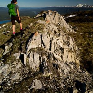
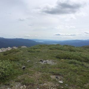
The Southern Tutchone name for Grey Mountain, The May, refers to to the grey-white colour of the rocks. Grey Mountain is a great day hike offering a terrific view of Whitehorse and the surrounding area. You can see from Marsh Lake in the south to Lake Laberge in the north. The trailhead starts only 200 m lower than the summit, which means more alpine walking. It's only 2.5 km to the summit, which is a good turn around point if you don't want to continue walking the ridge.
From the S.S. Klondike in Whitehorse, cross the bridge onto Lewes Blvd and make a left at the second set of lights onto Alsek Road. After 400 m, make a left at Tutshi Road (there is a sign indicating the cemetery and Grey Mountain viewpoint).
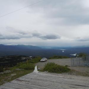
Follow the Grey Mountain Road to the Grey Mountain Viewpoint parking area at around 6.3 km. You can drive past this parking area for the remaining 4 km, but note the road becomes unmaintained and rougher with narrow sections towards the top. It is easily driveable in a vehicle with good clearance and some people even drive their cars all the way up. There is a good parking area right at the communication towers where the trail starts.
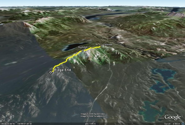
The route described here takes you to the first summit and back. There are actually a total of three summits you can reach if you continue along the ridge. See the Extended Hike Option.
From the trailhead, there are a few branches in the trail as you start out. It is typically best to stay right and in general keep to the most developed trail.
The trail continues gradually up and down as you approach the first main summit, where there are some switchbacks that climb steadily uphill.
The first summit is 2.5 km from the trailhead and offers great views of the surrounding area. Return the way you came, or see the extended hike options below for a longer hike.
Extended Hike Option
If you want to continue walking along the ridge, follow one of the main trails towards the second, lower peak. The trail can be faint at times.
To continue on from the second peak to the third, you will have to descend out of the alpine. This requires some very moderate bushwacking to the other side where you will ascend towards the third peak. There isn't much of a trail at some points, so pick your own way if necessary. The third peak offers the best view of Whitehorse. From here, turn around and follow the same route back.
Although this hike is close to town, there is evidence of bear activity such as bear droppings and digging marks. Act as you would on any other backcountry trail, making noise at intervals so as not to surprise a bear when you climb over a crest.
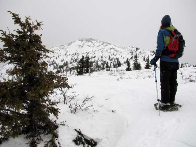
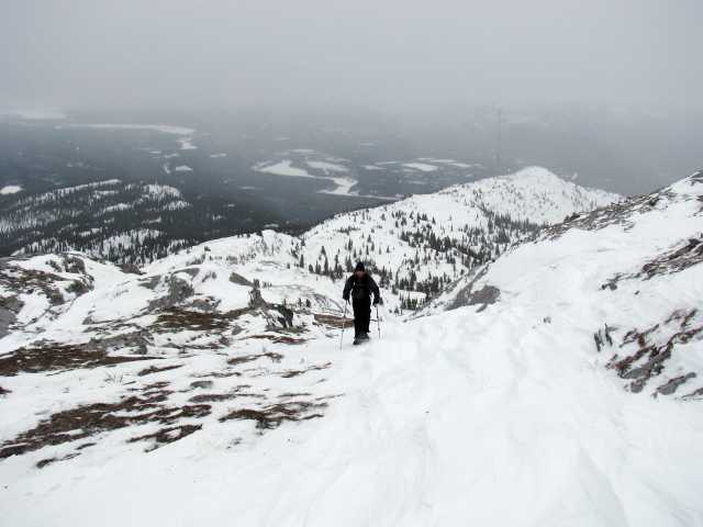
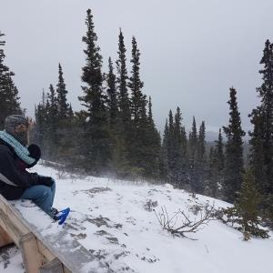
The top of Grey Mountain is excellent for a showshoeing or ski touring day trip. Note the unmaintained part of the road after the Grey Mountain Viewpoint parking area is not always passable in the winter and late into the spring. So plan for some extra time, about 1.5 hours one-way, to walk from the Viewpoint parking area to the communication towers.
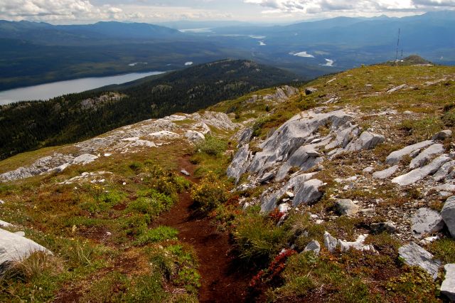
Looking back to the trailhead (radio towers) and all the way back to Marsh Lake.
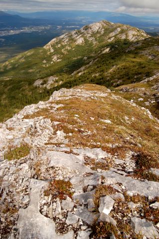
Looking towards the third peak from the second peak.
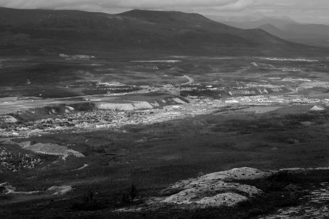
Downtown Whitehorse, nestled between the Yukon River and the river bank.
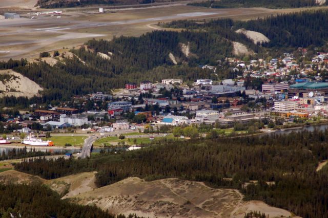
Downtown Whitehorse.

Looking south along the Yukon River.
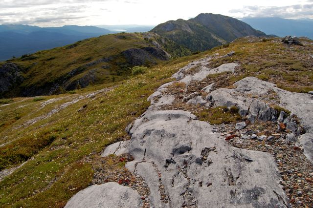
Looking back at the summit from further down the ridge.

The unmaintained road can be a little 'icy' at times.
Looking up towards the first peak.

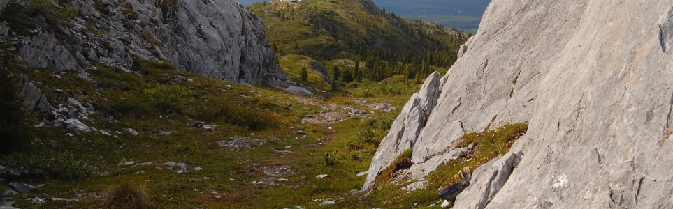
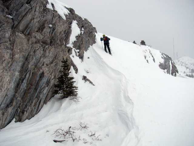
Exposed rock creates a canyon-like feel on the ridge.
Winter winds scour the top.
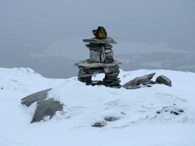
If the mountain is covered in clouds, cairns can help guide you.
The top of Grey Mountain is perfect for snowshoeing.
RM July 31, 2024
Drove a 4x4. Road is 100% dangerous halfway through the drive. Made it to the top. I would not attempt again.
ASJ September 5, 2022
I've been to grey mountain a few times this summer and tried driving the road (July and August). The road in August was way worst than in July and pretty sketchy and worn out. I do have a 4x4 SUV but didn't make it to the top. The first time I drove the road (in July) I parked at a pull-out around 2.4km from the top. The second time I drove the road (in August) I parked around 1km from the top but regretted driving that extra 1.4km as the road was pretty sketchy. If you don't have a 4x4 vehicle you shouldn't drive the road! I saw a regular (2WD) vehicle try to make it to the top and having to turn around not too far from the trail head
I made it out to the summit a few days ago and it was pretty flat and easy - a few very short steep sections where I had to watch my footing and be careful. And there was one part where the trail was narrow and I was holding onto the rock face for balance. Other than that no problems. Fall colours are out so it looked very nice!
Alex F. August 28, 2022
Amazing hike. Hit all 3 peaks.
Agreed that a 4x4 vehicle is needed. Didn't have a problem, but the drive up was quite slow and seemed a bit sketchy.
J&J August 23, 2022
Hiked this trail on August 19, 2022. One of the nicest, easiest hikes close to Whitehorse. Tremendous views in all directions. BUT, I would not take a 2 wheel drive vehicle beyond the 6.3k lookout. I took my F350 4X4 to the top and would never do it again. The road is now nothing other than a dry creekbed the whole way. The last 1/2 kilometer is an accident waiting to happen as you claw and scratch your way up the hill, hoping no one is coming down! Getting to the lower access points for this trail involve some driving on the "creekbed"! It's a shame!! If you care about your vehicle, avoid this road and hike unless you start the hike from the 6.3k lookout. Road past the lookout should be signed as 2 wheel drive only.
PC June 17, 2022
Someone in the last few weeks has spray painted orange on the rocks all the way from the tower asking area to the summit. Orange flagging too. Unknown if this has continued over to Dream? Anyone know the story?? Its not the Dream trail crew. Pretty uncool thing to do.
gord kolle July 24, 2019
In spring 1968, Danny Phillips and I were 15 years old and lived on Tagish Road. There was no hiking trail to Grey Mountain that we knew of. We packed some rations, took our dogs Taffy and Ringo and climbed the mountain with no equipment, just our hands. We started the trek at 5 am from Tagish and by cutting through the dew drenched blackfly infested swaqmpy forest, reached the mountain's base by sunup. We ascended the face straight up with the dogs, scrambling through rock outcrops, scrub, sliding shale and raced each other to the summit about lunchtime. It was great! I took a movie of the adventure with a handheld, 1966 Bell and Howell motion picture camera and got great panoramic shot of the town nestled in the valley...still have the movie (transposed to VHS.) I got injured by a flying rock on the descent, but it was worth it... It was one of the greatest adventures of my adolescent life, especially since we didn't tell our families we were going... we tried it again in November 1968 but a snow storm pushed us back down after we got halfway up the face...like i said, np trails back then and we wouldn't have gone if there were: what was the thrill in that? we were just two dumb teenagers lovin the slippery, icy winter danger...besides we only had lettuce and tpmato sandwiches on that trek....love my Grey Mountain memories...
Cath April 16, 2019
Went Saturday April 13th. There's still some snow at some parts, but not much, so you don't need snowshoes or anything. Just be sure you have good winter hiking boots.
You tend to lose sight of the trail sometimes, because of the snow and the mud. However, pretty nice hike! The view is awesome and beautiful. Worth it.
The unmaintained road was pretty dangerous. Even with a 4X4 pickup truck, we weren't able to get to the communication towers (too much ice). We stopped halfway on that sketchy road and walked to the trailhead.
Sarah Fletcher October 22, 2018
We went Oct. 20th. Didn't quite manage the drive to the radio tower, as we were not prepared for snow, and there was just a little; a small car passed us while we were walking to the trailhead, though! We didn't have winter footgear and brought a baby so opted not to do the trail but had some great views from the road walking up! Would love to do it properly.
Sarah September 1, 2018
Tried to do this trail Aug 25 and didn't even make it to the communication tower. It's a 10km road that is SUPER sketchy and you definitely need an SUV or 4x4. We had a rental car and tried driving it but after 0.5km we turned around. We met someone coming back in a car and said we shouldn't even try it. She went halfway and turned around. Apparently the last bit is a super narrow steep hill. The road is full of potholes and it would take a long time to drive. We ended up doing some other trails on Upper grey Mountain (B&S trail-mountain bike trail to Chadden lake). Lots of trails to choose from once you get up to the upper trails and it's fine in a car.
Garth July 15, 2018
Ran this route on the evening of July 9th. Trail is dry and in great shape. Pretty windy up top, should have brought another layer. Took two hours at a decent clip - almost all runnable if you're comfortable on uneven terrain. Top section of the road is in pretty rough shape, I was glad to have a truck.
Shailyn Drukis July 10, 2018
Did a 9.2km return trip from the car (parked part way up the mountain and walked to the tower). Lovely breezy day to keep down the sweat and biting insects. Saw a black bear on one of the ridges munching away on some plants (about 1/2 km away). Lovely day and always nice to bring visitors up there.
Paul Christensen June 5, 2018
Lost last winter along the Grey Mtn trail, maybe 4-500 m from the heli pad, one White climbing skin. Snow flake pattern on it. It was hanging in the willows along the trail last week apparently, so if you found it give me a shout, I'm in the book.
Thanks
T&C November 30, 2016
My husband and I did the "Easy Money" trail on Grey Mountain yesterday. It was a really snowy day! Easy Money is a nice snowshoe through the trees. Definitely has its steep parts, but you are rewarded with a cute little bench at the top of the trail (not the top of Grey). It was a very foggy day so we didn't have a clear view - but would be a great lookout on a clear day. Definitely chilly in the top open area, but a great snack/hot chocolate stop! :)
Kevin July 2, 2015
We went on Canada Day and it was great quick hike, took only a couple hours to go up to the summit and back. It was quite busy but an amazing way to spend Canada Day!
MP June 26, 2014
Beautiful trail, BUT...this has obviously seen more usage in the past few years. As you close in on the summit, the earth is greatly disturbed. Paths intersecting everywhere. This is sensitive alpine vegetation that is being trampled. Please hike with care, and stay on the obvious paths!
Rodger June 22, 2014
I drove up to the Antennas in a 1995 Toyota Corolla which certainly does not have any kind of road clearance at all. 98% of the road was fine in first gear. Just before the top I scraped the bottom of the car a bit - nothing severe. So it can be done, but you need to go slow over the bigger holes and protruding rocks near the top.
I would describe the hike from the first peak to the second peak as 'moderate' to difficult, depending on how much you are packing in and what speed you want to go at.
It is a very doable hike. Its impossible to get lost. The view are tremendous.
mikey January 25, 2014
I did this climb 2 feet and a heart beat all the way .....from start to finish.....twice to be exact. sure its an easy hike but wow extraordinary! i was in katimavik, youth program, me and me mates did it, from our house in riverdale 3 1/2 hours up 1 1/2 hours down. mid december. still have a rock from the top. beautiful memory! 1999
Luke May 27, 2013
Did this hike today (May 26, 2013) and while the road is a bit rough, the only reason we didn't go all the way to the top in a 2002 base model cavalier was because of the snow that was still covering the road. It was absolutely phenomenal in terms of views, weather and complete lack of bugs. I haven't done anywhere near all the hikes Whitehorse has to offer but this will stay near the top for views and lack of ridiculous effort.
Isaac June 16, 2012
Did this hike starting from the antennae. The drive up is a bit perilous, there are no railings at some spots and it's a long way down. If you're not comfortable with this kind of driving you may want to stop at one of the many parking areas located on the road leading up.
The hike itself is extremely rugged, at some places it is unclear as to where the trail even is. There is only one general direction to go, however, so getting lost is not an issue. The ruggedness warrants a sturdy pair of (preferably waterproof) hiking boots, there are many jagged rocks and uneven surfaces, mixed with some spongy marshes created by meltwater. My friends did the hike in sneakers but their feet did get a little wet.
The duration will most likely depend on how frequently you stop. People with less hiking experience will probably want to take frequent rest stops, as there are some steep inclines, and the views are so magnificent that you might spend a lot of time taking pictures. We walked close to the ridge end and it took us a couple of hours or so.
I highly recommend this hike, even if you are just passing through Whitehorse, as it is a very short drive from the city and won't take you any longer than an afternoon to complete.
Included is a panoramic view from the summit.
Marko Marjanovic June 9, 2012
We were able to drive all the way to the communication towers today in a small, low clearance car.
The ridge was mostly dry and the sun was out (18C this evening). We walked to the first summit, which took roughly 45 minutes at a leisurely pace.