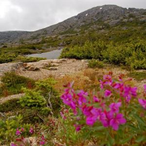
White Pass
Distance: 53 km
Elevation Gain: 3654 m (11988 ft)
Time: 3-4 days
Difficulty: Moderate
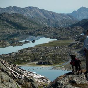
Follow the stampeders' trail on the infamous Chilkoot Trail. The trail wanders through a diverse landscape - from wet coastal rainforest, up to the rocky alpine and then to dry, lichen covered forests. There are campsites along the trail and facilities are provided at every site. Note registration is required with Parks Canada (Yukon) or the National Park Service (Alaska).
Elevation Gain: 3654 m (11988 ft)
Time: 3-4 days
Difficulty: Moderate
Follow the stampeders' trail on the infamous Chilkoot Trail. The trail wanders through a diverse landscape - from wet coastal rainforest, up to the rocky alpine and then to dry, lichen covered forests. There are campsites along the trail and facilities are provided at every site. Note registration is required with Parks Canada (Yukon) or the National Park Service (Alaska).
Distance: 10 km
Elevation Gain: 820 m (2690 ft)
Time: 6 hours
Difficulty: Difficult
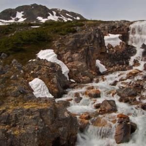
This route starts in the sub-alpine and follows along a creek with cascading waterfalls. Along the entire trail you get an amazing view of the mountain scenery all around you. The peak is rocky and feels like a proper mountain summit. Feather Peak is also a great area for a range of winter activities.
Elevation Gain: 820 m (2690 ft)
Time: 6 hours
Difficulty: Difficult
This route starts in the sub-alpine and follows along a creek with cascading waterfalls. Along the entire trail you get an amazing view of the mountain scenery all around you. The peak is rocky and feels like a proper mountain summit. Feather Peak is also a great area for a range of winter activities.
Distance: 5 km
Elevation Gain: 279 m (915 ft)
Time: 2 hours
Difficulty: Easy
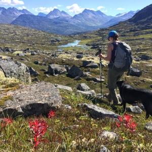
The easy hike to Fraser Lake (officially known as Bryant Lake but known to locals as Fraser Lake) has much to offer as a day hike or backcountry trip. Being so close to the highway it is a good introductory backcountry trip for young families or those people new to backcountry camping. There is much to explore from the lake if you want a longer hike. As a bonus in the fall, there are many blueberries to pick!
Elevation Gain: 279 m (915 ft)
Time: 2 hours
Difficulty: Easy
The easy hike to Fraser Lake (officially known as Bryant Lake but known to locals as Fraser Lake) has much to offer as a day hike or backcountry trip. Being so close to the highway it is a good introductory backcountry trip for young families or those people new to backcountry camping. There is much to explore from the lake if you want a longer hike. As a bonus in the fall, there are many blueberries to pick!
Distance: 11 km
Elevation Gain: 949 m (3114 ft)
Time: 5 hours
Difficulty: Difficult
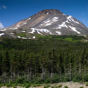
Fraser Peak looks like a giant wedge with a rocky top from the highway at Canada Customs. The hike to the summit is fairly moderate, with a few steep, scrambling sections. The expansive view from the top includes numerous glaciers, towering peaks down the White Pass, and the beautiful lakes and the unique moonscape terrain in this area.
Elevation Gain: 949 m (3114 ft)
Time: 5 hours
Difficulty: Difficult
Fraser Peak looks like a giant wedge with a rocky top from the highway at Canada Customs. The hike to the summit is fairly moderate, with a few steep, scrambling sections. The expansive view from the top includes numerous glaciers, towering peaks down the White Pass, and the beautiful lakes and the unique moonscape terrain in this area.
Distance: 6 km
Elevation Gain: 764 m (2507 ft)
Time: 3 hours
Difficulty: Moderate
The moderate slopes on the side of Fraser Ridge offer good skiing and amazing views. The angle is fairly gentle, and since the ridge is wide open and doesn't have a lot of bumps or trees, it's easy to find a route both up and down.
Elevation Gain: 764 m (2507 ft)
Time: 3 hours
Difficulty: Moderate
The moderate slopes on the side of Fraser Ridge offer good skiing and amazing views. The angle is fairly gentle, and since the ridge is wide open and doesn't have a lot of bumps or trees, it's easy to find a route both up and down.
Distance: 8 km
Elevation Gain: 292 m (958 ft)
Time: 2-3 hours
Difficulty: Easy
This hike is a real alpine treat, with easy walking along a beautiful fast-flowing creek with waterfalls, surrounded by mountains. As long as you can survive the very steep but short descent from the highway and the initial creek crossing to reach the main trail, then the rest of the hike is a walk in the park. The 'international' aspect of the hike is because the route starts on the Canadian side of the border and then crosses into the United States. Since the views don't change too much along the route you can easily make this a shorter or longer hike. If you add another 1 km (one way) you can look over into the next valley towards the Chilkoot Trail.
Distance: 6 km
Elevation Gain: 821 m (2694 ft)
Time: 3 hours
Difficulty: Moderate
A great year-round destination - most popular with backcountry skiers and splitboarders in the snowy season, but also a great summer hike. Stellar views from the top overlooking the White Pass Area as well as the Chilkoot Trail. According to the BC Gazetteer, there is no official name for this mountain, but other common names include Shallow Peak and Mount Halcyon.
Distance: 12 km
Elevation Gain: 905 m (2969 ft)
Time: 4 hours
Difficulty: Moderate
The Mount Cleveland area offers lots of varied ski terrain, from simple to advanced. The route described here is a traverse to the southeast peak, 2 kms from the true Mount Cleveland, and highlights the simple and intermediate skiing terrain. When the snow is good, there are some fantastic runs down into an open bowl or the glacier. The view from the top of this peak is amazing, and is worth the climb all on its own.
Distance: 4 km
Elevation Gain: 183 m (600 ft)
Time: 1.5 hours
Difficulty: Moderate
This hike is an easy way to get out and explore the alpine in the White Pass. You can hike up to a small ridge that has an international border marker which separates Canada from the USA. Hiking up even further offers a view down the valley towards Skagway. While the route is short, it is quite steep in places and route finding is required, as such it is rated as Moderate. Note this hill is named 'Outhouse Hill' because it is near the main viewpoint off the highway with outhouses.
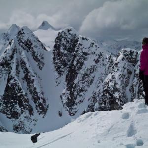
Distance: 11 km
Elevation Gain: 1221 m (4006 ft)
Time: 8.5 hours
Difficulty: Difficult
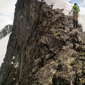
If you're looking for an adventure, then the Shark Fin hike is for you. The trailhead is a little unconventional as you will need a boat (canoe or kayak) to get across Bernard Lake to the start of the hike. The route takes you up to a precipitous sub peak on an unnamed mountain in the White Pass area. The name comes from the 'shark fin' shape of the peak, as viewed from the north. Good route finding skills and a head for heights are needed on this route.
Elevation Gain: 1221 m (4006 ft)
Time: 8.5 hours
Difficulty: Difficult
If you're looking for an adventure, then the Shark Fin hike is for you. The trailhead is a little unconventional as you will need a boat (canoe or kayak) to get across Bernard Lake to the start of the hike. The route takes you up to a precipitous sub peak on an unnamed mountain in the White Pass area. The name comes from the 'shark fin' shape of the peak, as viewed from the north. Good route finding skills and a head for heights are needed on this route.
Distance: 5 km
Elevation Gain: 128 m (420 ft)
Time: 2 hours
Difficulty: Moderate
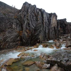
This route takes you to a dramatic viewpoint into the narrow, rocky canyon of Summit Creek. It is a beautiful trip in both the summer and the winter. After the canyon, the valley opens up and you can continue as far as you like, with many options to explore - left, right and center. This route is rated as MODERATE for summer, as there is tricky route finding through the trees and around the small lakes and creeks.
Elevation Gain: 128 m (420 ft)
Time: 2 hours
Difficulty: Moderate
This route takes you to a dramatic viewpoint into the narrow, rocky canyon of Summit Creek. It is a beautiful trip in both the summer and the winter. After the canyon, the valley opens up and you can continue as far as you like, with many options to explore - left, right and center. This route is rated as MODERATE for summer, as there is tricky route finding through the trees and around the small lakes and creeks.
Distance: 5 km
Elevation Gain: 390 m (1280 ft)
Time: 1.5 hours
Difficulty: Easy
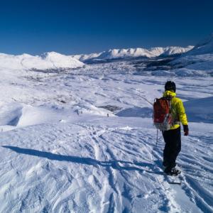
In the winter, Summit Creek Hill is a great place for beginner backcountry skiing. The route to the top is fairly short, follows simple terrain, and offers a fantastic view of the surrounding area.
Elevation Gain: 390 m (1280 ft)
Time: 1.5 hours
Difficulty: Easy
In the winter, Summit Creek Hill is a great place for beginner backcountry skiing. The route to the top is fairly short, follows simple terrain, and offers a fantastic view of the surrounding area.
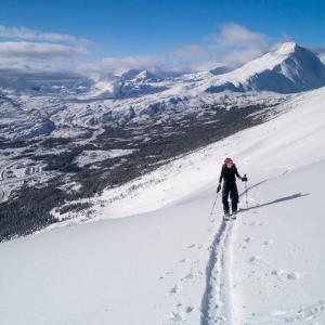
Distance: 10 km
Elevation Gain: 563 m (1847 ft)
Time: 4 hours
Difficulty: Moderate
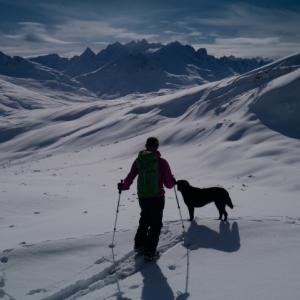
The winter route to Taiya SW3 (SW3 refers to the peak 3 kms southwest of Taiya Peak) starts off with a gentle ski tour and is followed by a mellow ascent up to a broad ridge. Feather Peak stays in view most of the way up, and you'll never get tired of the mountain vista from the top of the ridge. You can see the jagged peaks across the Chilkoot Trail and the mountains back towards the highway are equally impressive.
Elevation Gain: 563 m (1847 ft)
Time: 4 hours
Difficulty: Moderate
The winter route to Taiya SW3 (SW3 refers to the peak 3 kms southwest of Taiya Peak) starts off with a gentle ski tour and is followed by a mellow ascent up to a broad ridge. Feather Peak stays in view most of the way up, and you'll never get tired of the mountain vista from the top of the ridge. You can see the jagged peaks across the Chilkoot Trail and the mountains back towards the highway are equally impressive.