
Total Distance: 47 km
Return Time: 2-3 days
Elevation Gain: 2641 m
Difficulty: Difficult
Region: Annie Lake
Radelet Peak is a stunning mountain south of the Annie Lake Area with granite spires, iconic couloirs and glaciers. It is such a prominent peak that it can be seen from the tops of many other hikes in the area (Mount Anderson and Becker Peak, for example). This hike gets you up close and personal with the peak by hiking up one of it's beautiful valleys to a viewpoint above the glacier. To actually summit the peak from this valley would require rock climbing or mountaineering skills.
The driving access for this hike requires fording Becker Creek and the Wheaton River by vehicle, as these two main bridges have been removed. This means timing your trip for when there are lower water levels (mid- to late-summer) and having a suitable vehicle with high clearance and 4-wheel-drive. The hike itself involves hiking along the Berney Creek Road, an old exploration road with many rockslides and washouts. After that you climb a pass and head down to the Upper Wheaton River valley on the other side, which requires some bushwacking and route finding. After crossing the Upper Wheaton River, the route follows up another valley to the south with more bushwacking, route finding and potential creek crossing until you can climb up to the viewpoint.
From Whitehorse, drive south on the Alaska Highway to the Carcross Cutoff and turn right onto the South Klondike Highway. Drive south for about 17 km and turn right onto the Annie Lake Road. After 26 km on the Annie Lake Road, you will cross a bridge over the Wheaton River. The road is not maintained after this and is a bit rougher. There have been washouts in the past, requiring a higher clearance vehicle to get around (keep an eye on recent conditions for updates). Around 10.7 km after the bridge, you will reach the first of two water crossings, Becker Creek. After that it is 6.9 km of dirt road until you'll take a right onto a road that leads down to the Wheaton River crossing. This crossing is a lot more substantial, but doable in a 4x4 truck at low water (best timing late summer/early fall when runoff from snow melt is lower).
Once across the Wheaton River, drive on the main road for about 200 m and then keep left at the next main road junction. The road is in good condition for about 5.5 km until you reach some old mining gates (that were open as of Summer 2024). Here there are a lot of large rocks and bumps to navigate, keep to the main road to the right of all the rocky piles. After this, drive up the hill and take the next left, there is good parking here at the junction of Skukum Creek Road and Berney Creek Road. This is the trailhead.
Alternatively to crossing the creeks by vehicle, you could wade across the water crossings with a bike or e-bike to access the trailhead, but prepare for a 12.6 km bike ride (one way).
BERNEY CREEK VALLEY
The first part of this route follows the same directions as the Berney Creek hike.
From the parking area, continue hiking down the road towards Skukum Creek. The road here has a couple little washouts. Then you'll reach a large gravel parking area before the Skukum Creek bridge. The bridge has been washed out so you can either tentatively cross the broken bridge and drop down on the other side or cross the creek itself via boulders on the upstream side of the broken bridge.
After this you will be following the Berney Creek road for about 8 km. There are numerous rockslides that have enveloped the road most of the way up, and the road is completely washed out 2 km from the trailhead. The washout requires going up and around the vegetated rocky slope above. The many rockslides just require careful hiking on the loose rocks.
The valley here is beautiful as you pass the rocky peaks of Mount MacNeil (on your left) and Mount Reid (on your right). You'll leave the road after about 7.7 km, just before reaching the end of the valley at the turquoise waters of Berney Lake. You will now have to climb up the lower rocky pass to the south (left). It is very steep and many of the rocks are loose, so use caution. It is just over a 300 m high climb to the pass.
THE PASS TO THE UPPER WHEATON
Once at the pass, follow the valley down on the right side of the drainage. This drainage will take you all the way down to the Upper Wheaton River Valley (about another 6.6 km of hiking). Initially, you can stay low, just above the creek for most of the way as it zig zags downhill. You will soon get your first glimpse of Radelet, as well as Mount MacAuley (which is more to the southeast). As you get closer to treeline, you will need to do some steeper side hilling above the creek canyon. After that the terrain flattens out on a bit of a plateau with sparse sub-alpine fir and birch shrublands. This area was previously burned by a wildfire so you will see standing dead trees and burnt logs.
As you start dropping in elevation, you will have to make your way to the forested ridge line just to the right. This is in order to avoid the steep gullies now of the creek. You will need to bushwack for a little ways through birch, willow and fir. You can find the occasional wildlife trail to help you through. Keep heading downhill. The thicker conifer forest ends above the last bit of the hill, which is steeper and rockier now. It seemed to be best to pick a route about 100 m off to the right of the creek gully (on your left). Again, you can find wildlife trails to help you through it. You are aiming for one of the sandy hills that heads down towards the Wheaton River, directly across from the valley that leads to Radelet. Look for a very prominent wildlife trail below on the sandy hills.
Once down in the valley, follow the well-used wildlife trail towards the Wheaton River. There are good camping spots just above the river on the open sandy slopes.
ACCESS TO RADELET
To access some great views of Radelet from here, you will need to cross the river and head up the valley directly south. Expect about a 14 km return hike starting from the Upper Wheaton crossing and about 670 m elevation gain, depending on how far you choose to go to get close to Radelet Peak. Note to climb Radelet Peak itself from this valley would require rock climbing or mountaineering skills. There are more 'hikeable' routes available from the Primrose Lake side or up some of the other valleys, though many of these valleys are more vegetated than the access described here.
The water volume in the Upper Wheaton River crossing here is much lower than the one you crossed earlier by vehicle and should not be a problem to cross in late summer. Once across, traverse the short boggy section in the valley bottom to reach the drier sandy slopes above, heading south. The walking is relatively easy at first through dry open fir forests. The open forests will get a bit tighter as you continue up the valley. Follow any wildlife trails and openings in the forest where possible as you head up the valley, keeping to the right of the unnamed creek (looking upstream). Keep the same main trajectory (paralleling the creek) to gain elevation and eventually get out of the trees (about 2 km from the river crossing). Now there are some alpine shrubs to pick your way through until you reach the first open gravel floodplain.
Now there will be several alternating sections of alpine shrubs, boulder hopping and flat gravel and sand floodplains. In the open gravel floodplains, the creek is very braided, and you may find an easier route on the other side of the creek here and there. Choose your own route for what makes sense for the conditions. During high water these areas may be harder to navigate, and you may have to stay higher on the slopes and sidehill your way along. Watch for animal tracks in the sand and gravel (we saw sign of caribou and bear).
About 4.4 km up from the river crossing you will leave most of the bushy vegetation behind and be on rocks and alpine tundra vegetation for the rest of the way. As you travel up the valley you'll get more views of the amazing spires and beautiful mountains in every direction. While much of the surroundings peaks are sheer rock cliffs, there are some spots that you could explore with little side hikes. If you are looking to camp in this valley, we found the first decent camping spot about 5 km up the valley from the Upper Wheaton River crossing.
Eventually, you will start to see a narrowing of the valley towards a pinch point in the creek where the valley curves more to the right (west). There are many large boulders and loose rocky moraines. We chose to skirt up and around this on the right on a partially vegetated, steep slope to avoid the glacial valley ahead. It did look possible to simply follow the creek up and across the old glacial valley towards the actual glacier, though we did not know how stable the terrain there was. We opted to stay high on the right and try to get a more aerial view of the glacier and peak from above. If you go this route, be prepared to go up and down many rocky moraines and glacial rubble. The route on the right is worth the effort though, as you get up close with some of the surrounding rocky spires on the west side of the valley, and there is also another side glacier that enters the valley from the northwest.
Keep travelling across the moraines heading south towards Radelet Peak. We came across a very odd human-made rock formation of spirals on a small sandy plateau among the moraines. It was like coming across an alien crop circle, a surprise indeed in the mountains! Get as close to the end of the moraine ridges above the glacier as you feel comfortable for a great view.
Enjoy the views and return the way you came or explore some of the other ridges and glacial valleys in the area. Reverse the entire route on the way back to your vehicle in Berney Creek/Skukum Creek Valley.

The vehicle crossing of Becker Creek along the Annie Lake Road.

The vehicle crossing of the Wheaton River, as viewed from the far side of the crossing.

The broken bridge over Skukum Creek on the Berney Creek Road, as viewed from the far side.

Hiking up Berney Creek Road with the many rockslides.

Looking up towards the head of the valley where Berney Lake lies.

Looking up at the pass above Berney Lake. Route marked up in red.

Berney Lake as seen from above. You can see the Berney Creek Road continues up around to the north towards the Skukum Creek Valley.

The view looking down the pass. Stay just above the creek on the right for a ways down.

Once you round the corner coming down from the pass, you will need to stay higher and sidehill above the creek. You will have good views of Radelet Peak and the valley to reach it.
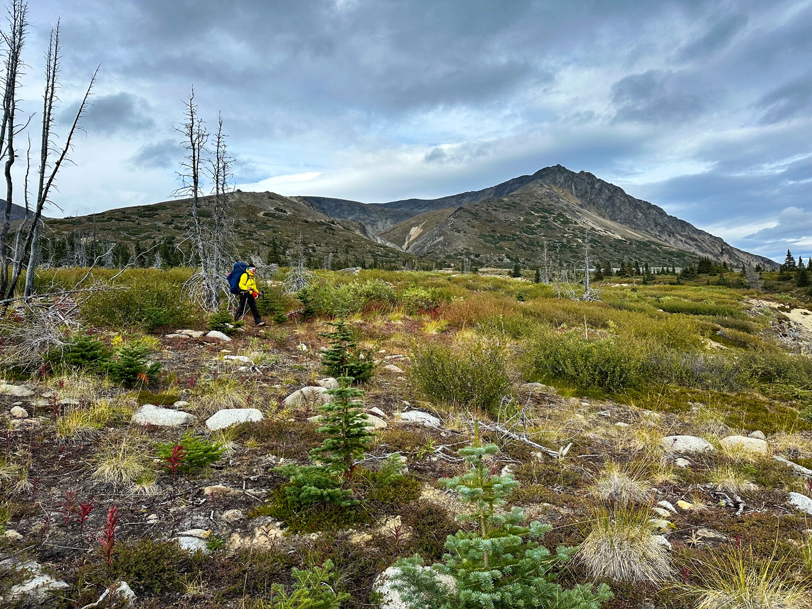
Traversing the small plateau at treeline and the remnants of an old wildfire.

The last bushwack down to the Upper Wheaton Valley. Aim for the sandy hill directly below with a prominent wildlife trail on it that leads to the Wheaton River.

Easy walking on the sandy hill.

The Wheaton River crossing (looking upstream) to reach the valley that takes you towards Radelet Peak.

The water volume in the Upper Wheaton River crossing here is much lower than the one you crossed earlier by vehicle and should not be a problem to cross in late summer.

After crossing the creek it is easy walking through relatively open fir forests. Watch for wildlife trails and openings in the trees as you head up the valley.

As you gain elevation up the valley towards Radelet Peak, the terrain alternates between bushwacking, open creek floodplains and boulder fields.

There are small ridges and valleys that you could explore once up the valley, however most mountains are sheer granite faces.

Once you reach the point in the creek where large boulders create a pinch point, you can head up and sidehill along the right.

On the right side of the valley you will be hiking up and down moraines beside some impressive granite ridges.

The route described here takes you to a viewpoint of Radelet Peak (sadly in the clouds for our whole trip) and its glacier below.

The morning view of Radelet Peak from our camp on the north side of the Wheaton River (still with its head in the clouds).

Hiking back up through the old burn with a final view of Radelet on our way home.

Heading back down the Berney Creek Road to the trailhead

