Total Distance: 42 km
Return Time: 10.5 hours
Elevation Gain: 1634 m
Difficulty: Very Difficult
Region: Kluane
Traditional Territory: CAFN
Auriol Peak is an impressive rocky peak, perched high between Quill Peak and Mount Martha Black within the Auriol Range. This route is accessible from the popular Auriol Trail in Kluane, and is best combined with camping at least one night either at the Auriol Trail backcountry campground or further into the alpine.
This hike starts from the backcountry of the Auriol Trail, at the footbridge, mid-way along the trail. See the Auriol Trail page for driving directions to the trailhead. The time and distance noted here are based on the full return trip starting and ending at the Auriol Trail parking lot.
Note: Parks Canada requires registration for any backcountry overnight trips in the park. There is no official name for this peak.
The first part of this route is straightforward and follows the well-maintained Auriol Trail to the mid-way point at the top end of the trail. Note see hike description on Auriol Trail page, and keep right at the main trail fork (2 km from trailhead). This route is shorter to the alpine. Watch for the old footbridge, mid-way along the trail, which is 500 m from the backcountry campground.
From the bridge, follow Auriol Creek upstream as it veers away from the main trail and leads west towards the alpine. There are multiple braided trails and open gravel bar areas along the creek, which will allow you to avoid the majority of the bushwacking. Keep in mind you'll likely have to jump or hop across the creek several times to keep out of the tangle of brush. The aim is to head towards the right side of the tongue of the moraine. When you get close to the moraine you have two options either to continue following the creek up through a gully along the right side of the moraine, or to gain higher ground and get up on top of the moraine. The moraine edges can be quite tall and steep with loose rocks, so feel free to continue up the creek until you find an easy spot to climb up. Note at this elevation the creek can often end up going under ground or snow, appearing periodically on the surface.
Now, if you've climbed up onto the moraine, follow along it's right side (above the creek) until you reach the back of the mountain cirque or bowl. If you chose to follow the creek, just continue following it and it will also end towards the back, right side of the bowl. At this point there should be a relatively steep snow or talus slope leading up to a low saddle towards the west. The climb up the snow or talus slope is approximately 350 m elevation gain, where it then levels out slightly onto a large open alpine plateau between two mountains. The true saddle between the two mountains is another 760 m away to the southwest, however you will have to hike up onto another small moraine and follow along it's ridge to the saddle. There is a stunning blue glacial lake that you'll pass by on the left.
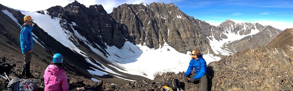
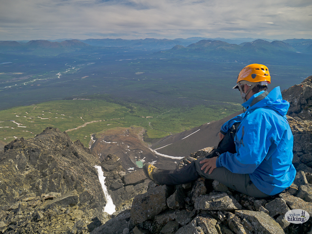
At the main saddle you'll get a beautiful view of Mount Martha Black (west) with her snowy, glacial cap as well as the glacial valley directly below. The Auriol - Martha Black Circuit route eventually drops down to this glacial valley. To continue up to the top of Auriol Peak, head southeast up the rocky ridge and slope. It is 530 m distance over 380 m elevation gain to reach the top. The climb involves some scrambling over loose rocks, so manage the way your group travels together to avoid rockfall, spreading out across the slope and watching out for people below. It's an exciting and beautiful climb and the 360 degree view from the top is well worth it as you can see the many peaks and glaciers of the Auriol Range and beyond, as well as back down the Auriol Trail and towards Haines Junction.
Return the way you came or for an added adventure take a look at the Auriol - Martha Black Circuit as an option.
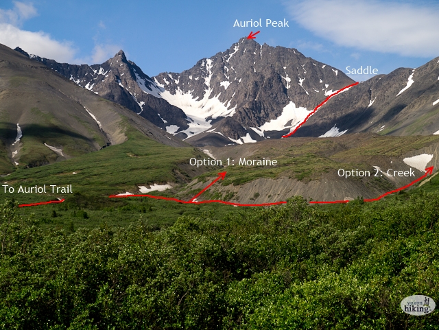
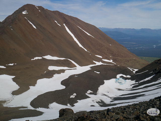
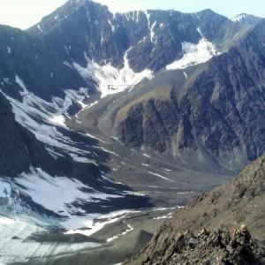
The view of the route to Auriol Peak as seen from the top of the Auriol Trail.
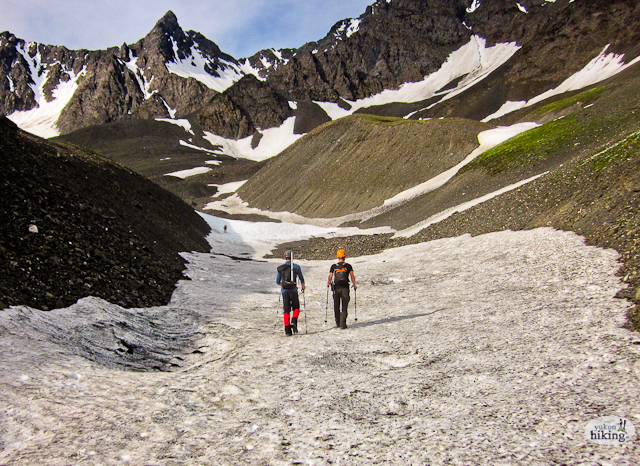
Following the creek up to the back right side of the bowl.
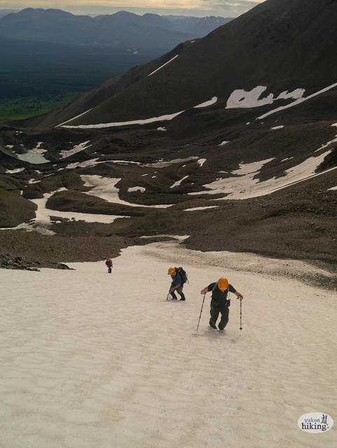
Climbing up the steep snow slope to the low part of the saddle.
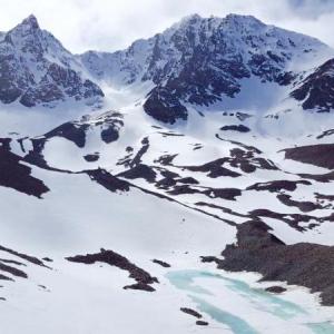
The small moraine on the way to the main part of the saddle, with the small glacial lake on the right.
The view northeast from the top of the peak.
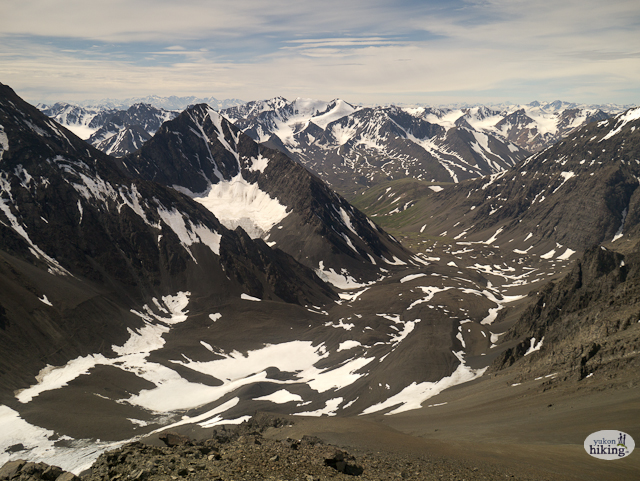
The view down the valley to the southwest, beyond the Auriol Range.

Soaking in the view of the glacier on Quill Peak.
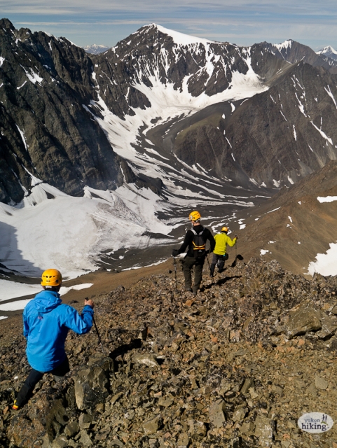
Descending the scree slope of Auriol Peak back to the saddle with views of Mount Martha Black and the glacial valley below.

Ethan July 8, 2024
Summit July 8 2024. Good conditions, up to the saddle requires a choice of loose scrambling vs snow so pick your poison. Snow climb is to the right and leads directly to the saddle. 1 very steep section and one undersnow creek but overall pretty good, gets very slippery late day. To the left of the snow option (in the middle looking up) is the scramble. Pretty okay, just remember to veer towards the snowpack as much as possible as it makes an easier root to the moraine before the saddle (accidentally tried to go up the peak on the ridge whoops). Super loose rock so try and find solid footholds otherwise a whole slide can occur. Some rock on the scramble section was breakable so check handholds as well. Did it in 12 hours with 1 major wrong turn (24 y/o, decent shape). If you are going to camp, do it at the moraine as you are only shaving 6km if you camp at Auriol Trail campground.
K.S. August 11, 2017
Successfully hiked up Auriol peak August 9 2017, after a previous attempt the week before. We took advantage of the midnight sun and did it in one day (I don't recommended this option). On our first attempt, we accidentally went up a subpeak, just east of the first talus slope. It wasn't until we climbed up over the super sketchy scree/talus and got on the ridge,(facing southwest) that we realized where the main saddle was. Apparently, this is a common enough mistake because it looks like it will connect to the summit.it doesn't. Our second attempt went a lot smoother as we were confident with navigating to the main saddle. Rocks/scree Very Unstable in the first section towards summit. This was the only spot on the hike that I was worried about getting injured. Don't rely on holding on to the seemingly stable rock and be mindful of footing as any step can trigger a rock slide. View from summit was amazing! Took us 14.5 hours with a few breaks in between.
**using trail with flagging tape after bridge easily leads to stream bed and saved us a bunch if time the second time around!
Susannah Robertson June 4, 2017
Hiked into the alpine lake located in the bowl. Round trip from the car took 6.5 hours. The trail is wet up to the campsite with snowy patches from the campsite up to the lake. There is still a lot of snow in the saddle so we did not attempt the peak.
Jo September 5, 2016
Inavertently went up a subpeak of Auriol on Sat. Sept 3rd. The subpeak is the obvious rock outcrop when you get into the first saddle. With the wintery conditions in Kluane right now, I opted to bootpack up gullies with two short 5m section nearing 45 degrees. Got clouded in at the top but it would be a worthy objective in its own right. Perhaps a traverse of the N ridge of Auriol would be feasible in dry summer conditions.
Marc August 23, 2016
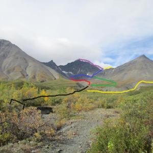
Did this hike August 21st. I started from the parking lot at around 11 am and reached the old bridge a few hours later. For me, I took option 1 by going up the moraine (black line). But instead of following Auriol creek from above that brings you towards the right of the mountain (green line) like described here, I followed a dry creek that led me up towards the left side of the mountain (red line).
I then noticed that I was heading towards the wrong peak, and went around to reach the steep talus slope with a few snow spots remaining (blue line). The 2 glacial lakes appeared on my right. They would technically appear on your left if you would've followed the green line. From there, you hike your way up to the main saddle (that you can't really see until you get close). There is a little bit of rock climbing involved and mostly scrambling. At this point, I almost turned around and was tired of making slow progress. However, I kept pushing and reached the main saddle after a few hours of scrambling.
I then went to Auriol peak (purple line). On the way down, I followed the Auriol-Martha black circuit (yellow line). This was a long scramble down beside the glacier and extremely rocky terrain. I ended up surviving and was back at the backcountry campsite around 10 pm that same night before hiking back to the parking the next morning.
Much respect to whoever's footsteps I was following on the last push to the summit! I know the effort it took to get there! As for the hike, expect a long difficult scramble but really impressive views of all directions once at the top. I would not do it again, but it was worth it!
Andreas Lazda August 15, 2015
Attempted to do this on August 3, 2015 as a daytrip (having setup at the Auriol backcountry campsite the night before).
Went up the eastern side of the morrain - which has much less vegetation (mosses/lichens/scrubby bushes) than the western side. Came across a large mound of fresh grizzly scat up on the morrain, but no sign of the bear itself (we had heard a large animal go crashing off through the woods at the campsite earlier in the morning, but assume that was a moose that got spooked when it noticed our presence). Did see a momma ptarmigan on the morrain - would have missed it completely given its excellent camouflage but it moved slightly as we happened to go past it. Instead of flying off, it stayed very close, and we saw why - it was protecting a small, even better camouflaged chick! We sidetracked around them to avoid stressing them further.
Up on the morrain we came across a partial ice cave down in a large depression in the rocks. You could make out the dirt-covered ice, dripping inside the tunnel. Couldn't explore more closely though because of the steep & unstable rock slope leading down to it. But still evidence of the former glacier from eons ago - very cool!
The saddle had a largish snow field that was being undercut by a waterfall so we didn't feel it was secure enough to venture onto, and in trying to scramble up the rock face on the side I pulled a sharp rock down onto my shin that split it open pretty badly. Fortunately, we had a comprehensive first aid kit along with compresses and pressure bandages so I was able to patch it up.
However, the accident and the challenging rock face, disconcerted my climbing partner and so we decided not to go further. So we didn't make it to Auriol Peak on this attempt :( Next time!
If the couple that we met at the campsite and again at the saddle, that did manage to get up and over, recognize themselves in this annecdote, it would be fun to hear how the rest of your hike went :)
