Total Distance: 27 km
Return Time: 10.5 hours
Elevation Gain: 1255 m
Difficulty: Very Difficult
Region: Kluane
Traditional Territory: CAFN
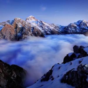
This circuit route takes you off the beaten track of the popular Auriol Trail, taking you across a moraine, up to a mountain saddle, down a glacier and across a beautiful alpine plateau. This hike is best suited to setting up a base camp at the Auriol Trail backcountry campground or somewhere higher in the alpine.
NOTE: The route has changed slightly, as described below, due to a recent landslide and rock avalanche. The mountains and landscapes are changing and you may encounter different conditions along the route than described here.
This hike starts from the backcountry of the Auriol Trail, at the footbridge, mid-way along the trail. See the Auriol Trial page for driving directions to the trailhead and to add distance and time to the reach the footbridge. The time and distance noted here are based on the full return trip starting and ending at the Auriol Trail parking lot.
Note: Parks Canada requires registration for any backcountry overnight trips in the park.
The first part of this route is straightforward and follows the well-maintained Auriol Trail to the mid-way point at the top end of the trail. Note see hike description on Auriol Trail page, and keep right at the main trail fork (2 km from trailhead). This route is shorter to the alpine. Watch for the old footbridge, mid-way along the trail, which is 500 m from the backcountry campground.
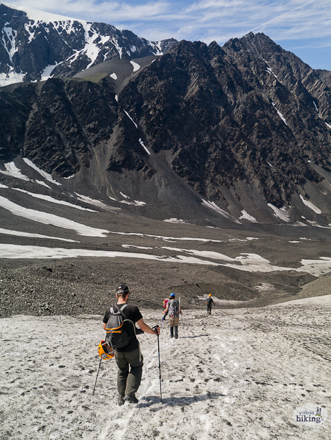
From the bridge, follow Auriol Creek upstream as it veers away from the main trail and leads west towards the alpine. There are multiple braided trails and open gravel bar areas along the creek, which will allow you to avoid the majority of the bushwacking. Keep in mind you'll likely have to jump or hop across the creek several times to keep out of the tangle of brush. The aim is to head towards the right side of the tongue of the moraine. When you get close to the moraine you have two options either to continue following the creek up through a gully along the right side of the moraine, or to gain higher ground and get up on top of the moraine. The moraine edges can be quite tall and steep with loose rocks, so feel free to continue up the creek until you find an easy spot to climb up. Note at this elevation the creek can often end up going under ground or snow, appearing periodically on the surface.
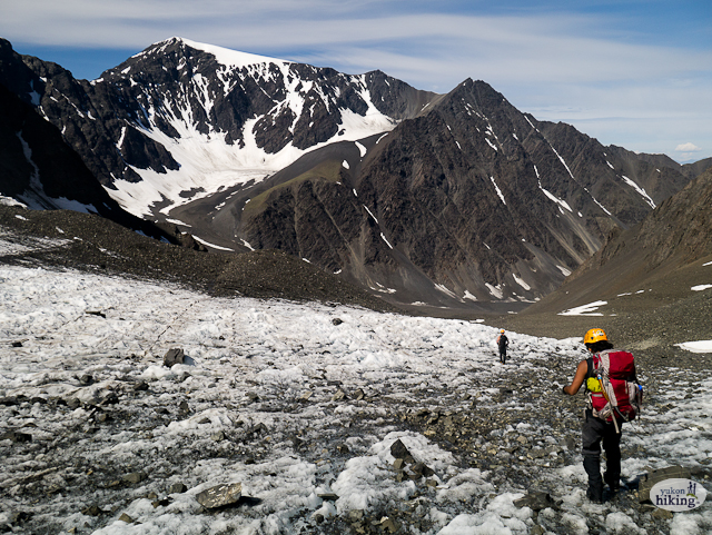
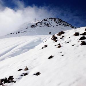
Now, if you've climbed up onto the moraine, follow along it's right side (above the creek) until you reach the back of the mountain cirque or bowl. If you chose to follow the creek, just continue following it and it will also end towards the back, right side of the bowl. At this point there should be a relatively steep snow or talus slope leading up to a low saddle towards the west. The climb up the snow or talus slope is approximately 350 m elevation gain, where it then levels out slightly onto a large open alpine plateau between two mountains. The true saddle between the two mountains is another 760 m away to the southwest, however you will have to hike up onto another small moraine and follow along it's ridge to the saddle. There is a stunning blue glacial lake that you'll pass by on the left.
At the main saddle you'll get a beautiful view of Mount Martha Black (west) with her snowy, glacial cap as well as the glacial valley directly below, which is where you'll need to go to continue on this circuit route. Before dropping down from the saddle, consider climbing Auriol Peak for some even better views (see previous page for route description.
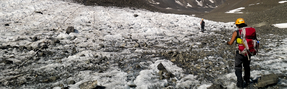
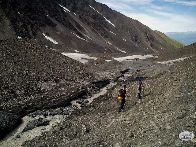
Leaving the saddle, drop down the scree slope to the glacier below (200 m elevation). Much of the glacier is covered in gravel with glacial melt channels flowing on top of the ice. The glacier is not crevassed aside from a small ice fall midway down on the left. This ice fall provides a unique opportunity to play around and climb some grade 1 ice if you happen to have crampons and ice tools.
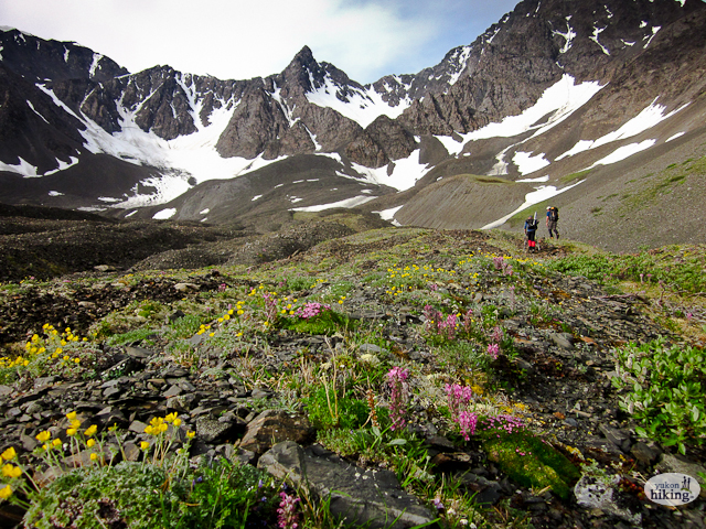
The circuit route continues down the glacier, following along the right side of the creek. Keep following along the right side of the creek northwest and north in the direction of Haines Junction. The creek at one point will disappear under the ice and gravel only to re-emerge a few hundred meters downstream. Keep following the creek, staying safely on the rocky talus benches above, contouring along the side of a large mountain. Do not go too low as you will need to stay somewhat high to gain the alpine plateau which eventually leaves the creek and the rocky, glacial outwash valley, and instead circles northeast and east around the large mountain. On the alpine plateau the rock and ice of the glacier are now replaced with green slopes blanketed in wildflowers.
Continue along the plateau heading east. NOTE: NEW HAZARD ALONG ROUTE. As of October 2023, a very large landslide/rock avalanche has occurred off the side of the mountain. The slope is still very unstable and it is not recommended to traverse this area. The same signs of instability are showing in the areas adjacent to the landslide, so do not camp in the area or linger too long. You should drop down well below the unstable area and then pick up the route when it is safe to do so.
Eventually you will reach a small creek gully which you'll have to descend to and then head back up to reach the next section of plateau. It is another 1.6 km to the southeast with a gradual uphill and then downhill, to the next creek gully, which is the same creek (Auriol Creek) that you started at originally. A GPS is very useful to help you pick up your original trail. Once you meet up with Auriol Creek, you can return the way you came up and get back on the Auriol Trail.
Walking up the moraine at the start of the circuit.

Hiking up the steep slope to gain access to the saddle.

Descending into the glacier valley from the saddle. Mount Martha Black is in the background.
Hiking along the gentle glacier and moraines.
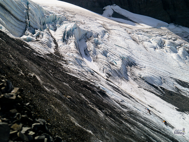
Ice climbing on the ice fall.
The hiking along the glacier is easy and the scenery is amazing.

Rounding the corner of the glacier valley.
Around the corner, you can start staying up on higher ground.
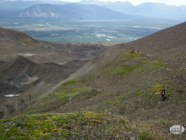
Up above the glacial moraines with Haines Junction in the background.

Looking back towards the glacier valley.
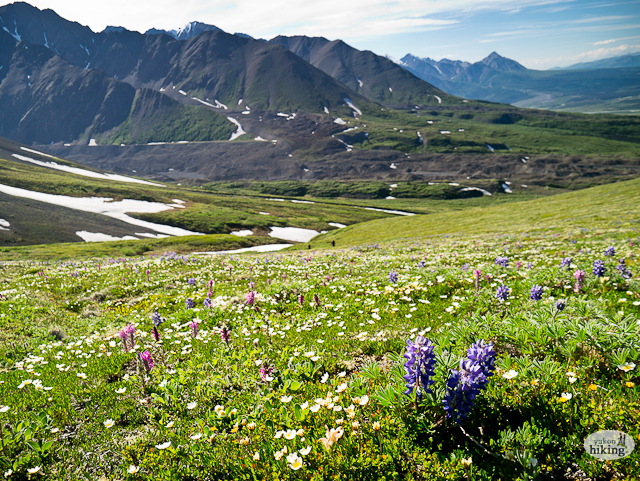
Rocks turn to alpine vegetation and wildflowers near the end of the circuit.

Scott Chadwick June 29, 2023
June 1st 2022, snow pack unstable, thick crust with breakthrough variables, fixed points mandatory on summit ridges, ledges and chimneys, max 8c base temp, minimal frozen flow, excellent conditions, wind 10 - 20 km, 20 meter approach width, min -12c upper elevations, wind 20 - 40 km, spectacular views, full moon, many varieties of edible alpine vegetation to compliment dry packs, bivy, -35 synthetic, layer up - down methodology, an amazing adventure, easy access, use extreme caution above saddle, inversion on day 3. What a mountain!. GO light!
Abby July 2, 2021
Hiked July 1,2021
Not really a route after the Auriol trail. We had thought it was a total of 12km (from the description) but our hike ended up a total of 30km because we didn't account for the Auriol trail section). We did add the Auriol Peak Summit which was well worth it for the extra views. River flow was strong before hitting the moraine you would definitely have to walk through the water as we could not jump rocks. Lots of tough scrambling through shale. We kept our distance from the glacier outflow just to be safe. Cross high on the meadows after leaving the glacial river to avoid a lot of bushwacking to return to the starting moraine. The bugs were after us in the woods of the Auriol trail so lots of bug spray is needed. With some stops for views, bit of confusion on where to go and some slow scrambling we completed it all in 11 hours. Beautiful views and a fun challenge!
Fabian S. June 30, 2021
Just did the Martha Black circuit. What an amazing and beautiful route! Conditions were great. The snow patch up to the saddle is pretty steep and I was sure happy about bringing crampons. I did not have an ice axe but it would have been a great addition under current conditions. If you slip off on the steep snow you are in for a long and steep slide that will see you hitting the rocks at the bottom. Injuries almost guaranteed! I used the downloadable GPS track for navigation and it was excellent! Only 50 meters off to either side of the track may see one in dangerous terrain with even steeper slopes, lots of loose rock, rockfall etc. While I found the saddle area (ascent and descent) somewhat challenging, the views are spectacular and worth the struggle!
Jo September 5, 2016
Wanted to attach a photo of that subpeak viewed from the first saddle
Jo September 5, 2016
Hiked the Auriol-Martha Black Circuit on Sat Sept 3rd. Lots of snow up high in Kluane, up to 30cm new snow with a hard breakable crust. Went up too far towards the base of Auriol in the bowl and started working my way up steep chimneys before changing my ming and losing at least 100m elevation to gain some obvious ledges 50m down and 50m right of an obvious waterfall. Looking back at my original route, I think it would've gone but with some exposure avoided on the proper route. The snow was so deep that I tried to gain elevation and stay high in the shallower but more supportive snowpack and ended up shoepacking up a subpeak of Auriol from the first saddle thinking it would connect with the main summit. It didn't under current conditions. Two short 5m section near the top were probably 45 degrees. Got clouded in at the summit and quickly worked my way back down towards the real saddle. The slope down to the rock glacier was steep with lots of snow and signs of recent snowballing and even avalanches up to size 1.5. It was still early, overcast and chilly when I was there but something to keep in mind. I had to downclimb the top part of the slope and then follow wolverine tracks (mother and young I think) to snowline. Stayed high in the moraines at about 1350m and worked my way back to my morning junction. Great trip!
Nicola July 14, 2016
We've done this hike twice - most recently July 8-9. Hiked into the campsite on Friday night after work and did the circuit and out on Saturday.
Lots of flow in the camp creek despite what we were told at the visitor centre. Getting up to the saddle was a bit tough - we took the route straight up the snowfield, then bailed to the right near the top and scrambled up the red rocks. The view from the alpine plateau was lovely and the route across is obvious. Once you descend the scree slope onto the glacier, I would recommend staying on the glacier longer than the GPS route reads - this avoids hiking along a steep talus sidehill. You'll have to cross the river eventually, but there was an ice bridge more than 20m wide when we were there, allowing for safe crossing.
We saw a moose in the meadows from the moraine :)
Overall a good trip - great views from the saddle and fun walking on the glacier - made the tedious navigating of the talus slopes worthwhile.
