Total Distance: 9 km
Return Time: 5 hours
Elevation Gain: 868 m
Difficulty: Difficult
Region: Carcross
Traditional Territory: CTFN, TRTFN
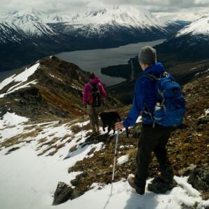
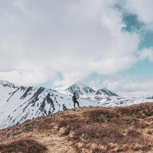
This hike offers sweeping views of Tutshi Lake and the surrounding mountains. There is a lot of steep scree to climb up to the ridge but it is a fun, narrow ridge to walk once on the top. It is a favourite early-season hike as it is south facing with early snow melt. As a bonus watch for Mountain Goats on the ridge.
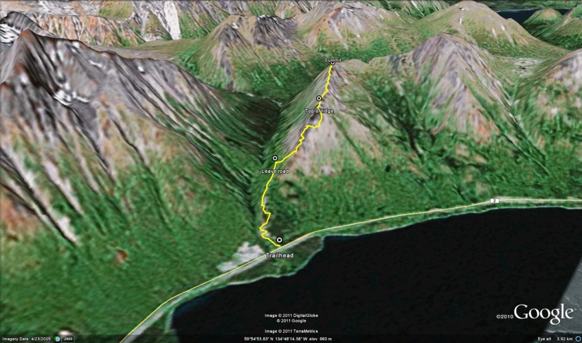
From Carcross, continue south on the South Klondike Highway (towards Skagway, Alaska) for 38 km. You will reach a rough gravel road on the right side of the highway. Park here. It is just before a creek and gravel pit. The road is on the north side of a creek. If you come to a gravel pit (on the south side of the creek), you have gone too far.
Note: There is no official name for this mountain.
From the highway, walk up the steep gravel road. There is only one fork in the road. Stay left, although they meet up again very quickly.
After about 1.7 km into the hike, the road comes close to the start of the ridge in front of you and minimizes the bushwhacking required to get to the ridge. Leave the road and head through the trees to the base of the ridge. The bushwhacking is not that bad and very short. Head up the ridge until you get to a large piece of vertical rock. Instead of climbing the rock, head right (northeast) across the steep scree slope in order to come around the other side of the ridge. This is the most difficult part of the trail, but don't be discouraged as it is actually easier coming back down.
After walking on the scree slope for about 300 m, you will notice a route up above you that avoids all the vertical rock. Head straight up and you will come to the top of the ridge.
The route from the top of the ridge to the summit is obvious, but is fairly narrow so be careful if there is still snow on top. From the ridge, you get a great view of the surrounding area and a closer view of Paddy Peak to the west (your left). Follow the same route down.
EXTENDED HIKE
There is another higher summit you could continue to along the same ridge, around to the northeast. You will have to drop down to a saddle and then gain another several hundred meters elevation. Add about 3.5 km and 2 hours (return) to the hike.
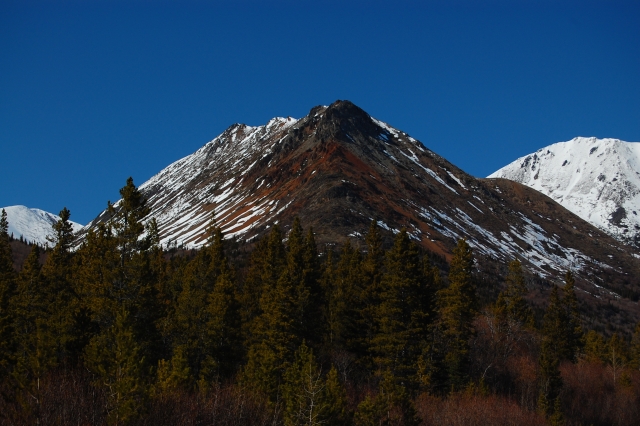
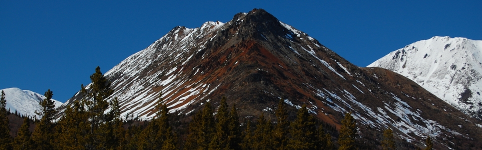
The ridge is dark and rocky with a band of red coloured rocks smeared across both sides of it.
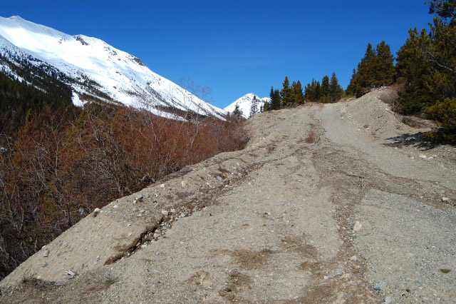
Follow the gravel road for about 1.7 km as it climbs up near the ridge.

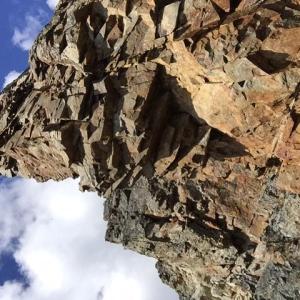
Pick your way up the red rocks until you reach the grey vertical rock.
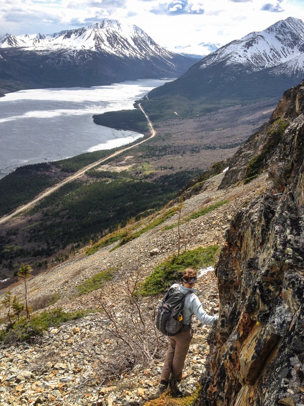
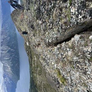
Head laterally across the scree with views of Tutshi Lake below you.

Looking down towards the road and across the valley.

Heading up around the side of the vertical rock to the ridge top.
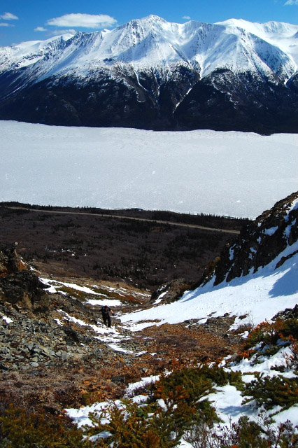
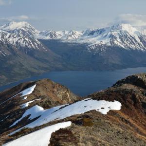
Looking down the trail from near the top of the ridge with Tutshi Lake in the background.
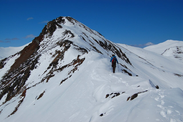
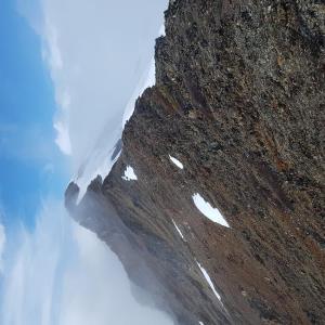
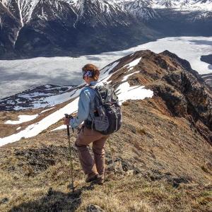
Walking along the ridge. If snow is still present, watch for any overhanging cornices.
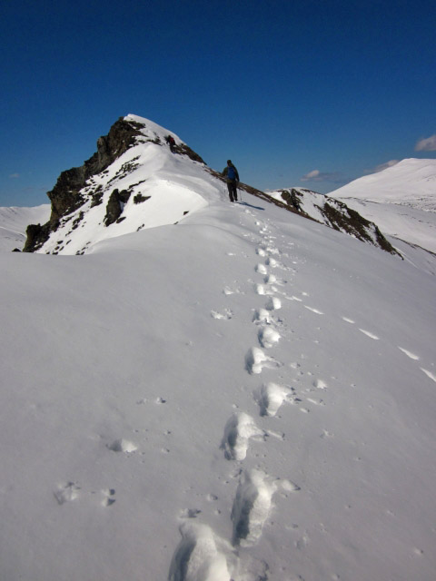
En route to the summit.

The 2200m summit of Paddy Peak as seen from the summit.
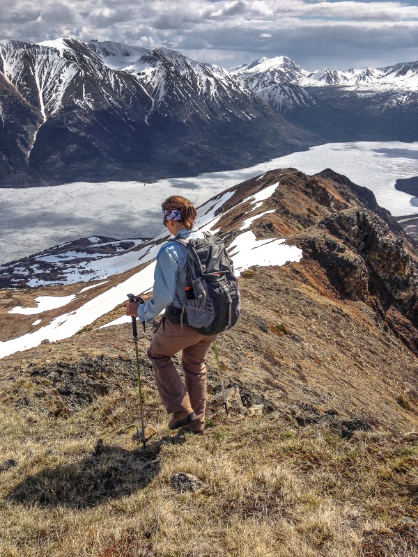
Walking back down the ridge with a sweeping view of Tutshi Lake and the surrounding mountains and valleys.
ADRIAN MAZZUCCO January 5, 2026
Good evening and happy new year
I am very interested in hiking Tutshi area can i get a truck close enough to the lake to put a boat in the lake and travel it for a few days a week ?
Sean June 1, 2024
Did this last weekend (May 26) and it was dry and clear except for a couple
Of patches of snow on the ridge. Time seems like a bang on estimate (5 hrs return).
Nicole June 25, 2023
Did this hike on 6/24. There were some sticks marking a path on the right off the road that we took to get up to the ridge. Bushwhacking was short and not bad at all. I don’t think we followed the exact route on here but it worked! Took goat paths across the scree, some sections were looser than others but nothing too bad and I was fine in my trail runners. Hit the ridge and continued to the summit - there’s a section on the way where the hillside is starting to breakaway and there’s a few land crevasses, so watch your step! Beautiful views of the lake and towards Paddy. We ended up taking one of the more mellow gullies straight down to the road from around where we hit the ridge, prime scree skiing!
Ben Feltmate June 14, 2023
Hola!
I lost my phone on the Paddy's Peak road between the highway and the creek. There's a $300 reward for anyone who finds it. Black Samsung S10. If you find it, please let me know, it would mean the world to me :)
Thanks!
Ben
AJ August 22, 2022
Hiked on Aug 21. Echo what others said, bring sturdy shoes and hiking poles for the scree. Scree section isn't all that bad and fairly brief.
Great view of Tutshi Lake and the surrounding mountains.
Maury June 20, 2021
Apart from the shitty scree and rubble to gain the ridge proper, this is a great hike. Bring real hiking boots and poles - your running shoes can stay in the car for the drive home. I highly recommend starting quite early and doing the real summit - the time spent in the alpine is wonderful! On June 19, the ascent slopes to gain the ridge were cooking hot from the sun on the way up and the heat was miserable. A 9am start was too late for us on this day with the encountered warm weather and sun. Including the true summit, my Garmin GPS recorded 14.3km and 1401m (cumulative gain). It took us 6h40 return. Happy hiking!
Matt Ainsley May 26, 2021
May 26th
Managed to climb to the summit today. There is still a good amount of snow on the track up. It is very soft which made for some fun postholing. The alpine is almost clear of snow, except for some areas on the north side of the ridge nearer the summit. It was no issue to skirt around. A mixed bag of weather today, but stunning views from the top when the clouds blew over!
Great views over the surrounding mountains. Still all completely snowcapped.
Carlos May 4, 2021
May 2nd: deep snow from the highway on but snowmobiles had packed it down on the road so going was easy, especially in the morning before the sun hit it. We had crampons and hiking poles and chose to kick steps up the steep hillside but stopped short of the ridge in order to make it safely down and out before the snow got too soft. A Grizzly chose the same route but climbed up before us. On the way out, the snow on the lower road was very soft and we postholed almost the whole way which earned us coffees in Carcross on the way home.
Liz B May 18, 2020
Hiked this on May 18. No snow anywhere along the route.
I am a fairly experienced hiker but this one definitely tested my comfort limits. There are lots of extremely steep sections with loose rock. Make sure you're ok with steep sections and loose scree if you're planning on doing this one.
Overall we were able to make our way up to the summit following the written directions. It's a pick your own route in some parts but not difficult to figure out where to go. The bushwacking was very minor, we found a really easy route through the willows and marked it with an arrow made out of sticks on the side of the road.
Good ankle support and hiking poles recommended for this one!
Kate August 6, 2018
We hiked to the summit yesterday. It was a challenging hike, made more difficult by our misunderstanding of some of the corrections in the comments below. We waited too long to cut toward the ridge through the trees and ended up hiking up the backside of the mountain (south west side). It was mostly scree, with some challenging chutes to shimmy up. I wouldn’t recommend it. We gained the ridge about 1/2 way up, which made for a pretty easy walk up to the summit.
Not sure we caught the trail back down, but the route we found was much less sketchy than the way up. Mostly, we went down the north east side and hugged our way under the rocky outcrops until we reached the south side (with some adjustments depending on the scree). Then we picked our way back down toward the road.
The view from the top gave a really good view of the smoke plume from the fire on the Windy Arm, but without suffocating in smoke, as the wind was blowing away from us.
We were just under 5 hours up and back.
Pippa June 4, 2017
We hiked to the top of the ridge (not summit) today (3 hrs). We followed the directions but (like Esther?) hit the ridge lower down, at the fist big rocky prominence. Going around the NE side of the lower knob was a tricky scramble, not advisable. (Aim for the second big rocky knob on the ridge.) This hike is worthwhile for the views, but you need to be comfortable with loose and crumbling rock on steep slopes. High risk of rockfalls. Note: there's a guy camped semi-permanently at the base of the hike. He tried to dissuade us from hiking it given the dangers.
Esther June 2, 2017
Did this hike on May 26. The side hilling wasn't super fun. We were too eager and topped out on the ridge too soon... had to backtrack and go back up. SO WORTH IT THOUGH! The views were stunning. This hike is clear of snow. Paddy peak and the road to get to it still has a lot of snow.
Lia June 15, 2015
My Blue Yukon Brewing Hat got blown off while we were on the hike. If anyone finds it, send me a line - lia.cyd AT gmail.com
Hiked this over the weekend. There was a more scree than we had expected, but it was OK overall. We didn't actually make it to the summit, as we didn't walk north enough/around the vertical rocks to reach the true summit and see around the backside of the mountain. Next time!
(the picture is from where we stopped, but re-reading this I see you can go around this big rock pinnacle to the summit)
David M May 25, 2014
Did this hike yesterday - great views over the lake. Hiking time was about 4.5 hours. For anybody interested in Paddy Peak, large sections of the access road are still snow-covered, from the point at which it leaves the main valley onwards.
Marko Marjanovic May 18, 2014
This hike is a spring favorite of ours, since it is one of the first trails to be snow-free. We saw ptarmigan, grouse, and one very large goat up on the ridge. It took us about 5 hours return, but we didn't spend much time at the top.
The road below to Paddy Peak was still snowed in and there was lots of snow on Paddy Peak still.
Jenn March 18, 2014
We hiked up Tushi Bend trail last weekend and it was snow free. The road had snow and there was 5 mins of bush-whacking to get on the hill proper but it was a great hike. A little short we were up and down in 2 hours with a 10 year old.
Marko Marjanovic June 5, 2012
The ridge was mostly snow free this weekend and the road only had a few wet patches on it.
We took another route down from the ridge this time. We went down the south side of the ridge (the same side as the gravel road) a few hundred meters before the start of the ridge (where you initially climb up). It was steep! We had to descend one at a time because of the rocks that would fall as we moved. There are some areas like this on the route described on this page, but this new route was steep all the way to the bottom. Not recommended, stick to the same way you came up.