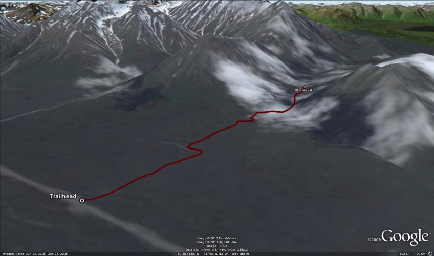
Total Distance: 8 km
Return Time: 2 hours
Elevation Gain: 120 m
Difficulty: Easy
Region: Kluane
Traditional Territory: CAFN
St. Elias Lake is a short hike with great rewards. There is a backcountry campground at the lake, which is nestled between tall mountains. This trail is great for beginner backcountry camping because it is a short trail to a campground with amenities. It is also great to do with kids.
From Haines Junction, drive towards Haines, Alaska on the Haines Highway for about 60 km. There is a pullout on the right-hand side of the road and a sign will indicate the St. Elias Trail.
Note: This hike is within Kluane National Park, and Parks Canada requires registration for any backcountry overnight trips in the park.
The trailhead is right off from the highway pullout and easy to follow. The trail has a few ups and downs, but becomes relatively flat near the lake.
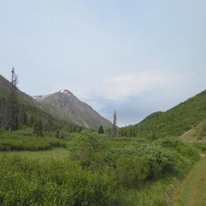
The trail meanders through the trees for a couple of kilometers and then opens up with views of the surrounding peaks. The trail then travels through a meadow once out of the trees for the rest of the way to the lake.
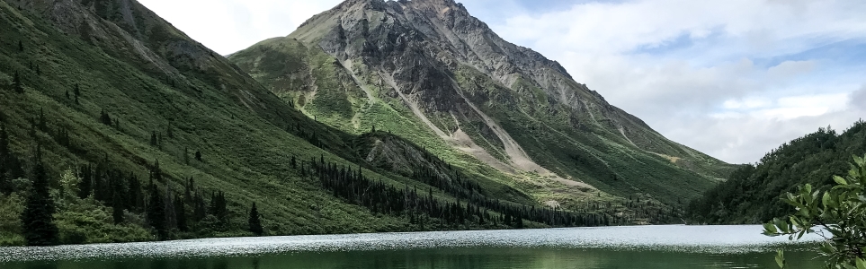
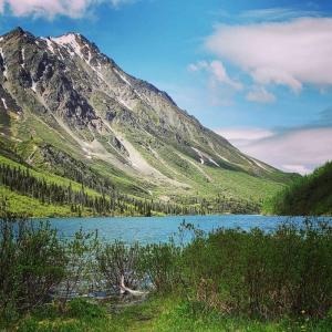
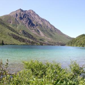
The lake has designed tent sites, a food cache, a fire pit with benches, and an outhouse. There is a great view of the surrounding mountains from the lake.
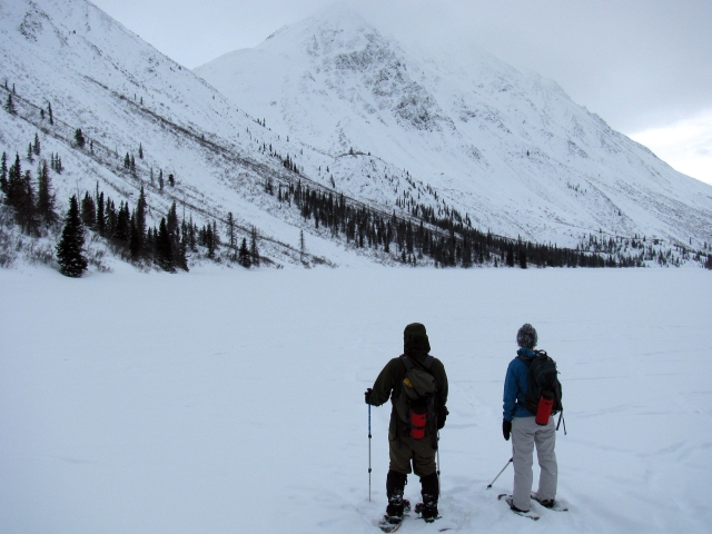
The trail is often tracked for x-country skiing in the winter. Snowshoeing is also a great option. Once you get to the lake, if it is frozen you can continue right to the opposite end of the lake.
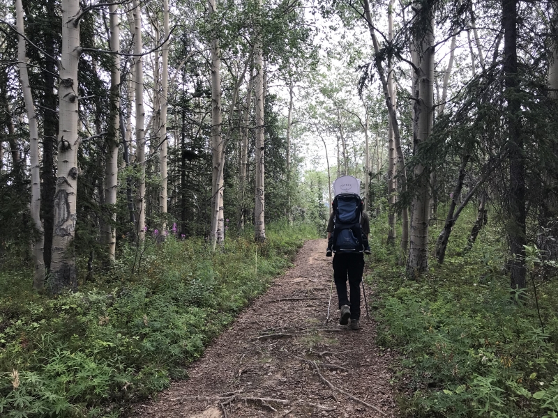
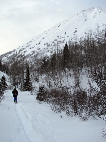
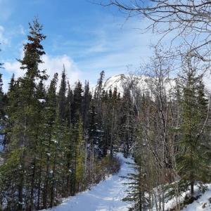
The majority of the trail is a wide, easy path to follow through the forest.
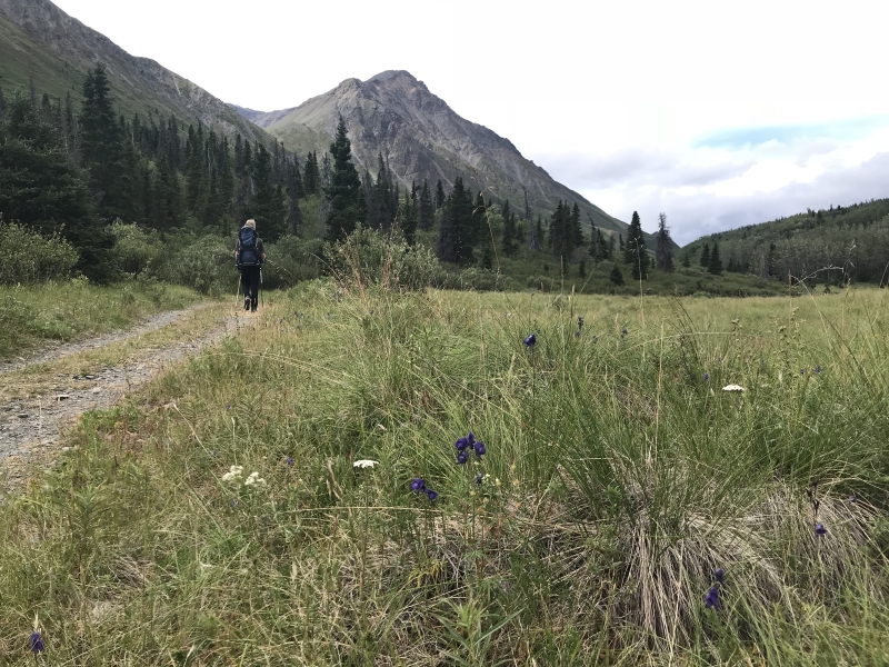
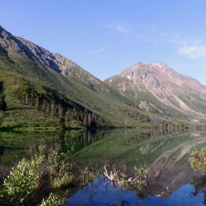
The flat section near the lake where the view opens up.
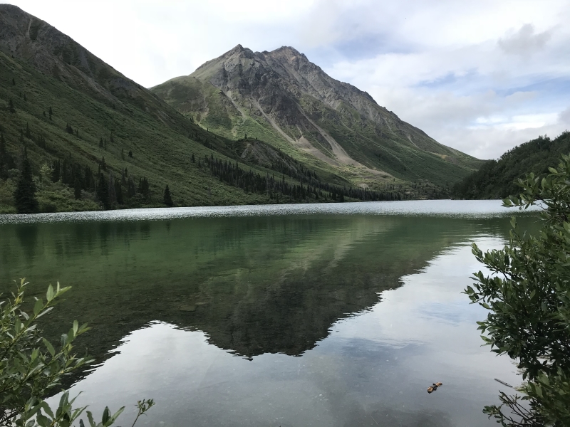
Looking down St. Elias Lake from the campground.
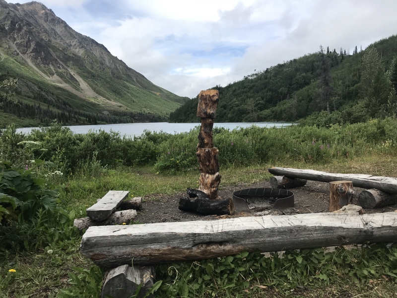
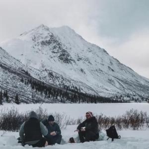
The day use and campsite beside St. Elias Lake.
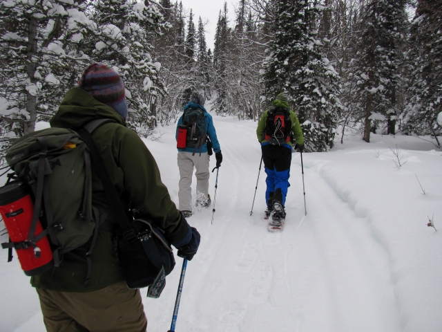
Snowshoeing near the beginning of the trail through the trees.
The flat section near the lake where the view opens up.
Looking down St. Elias Lake from the campground.
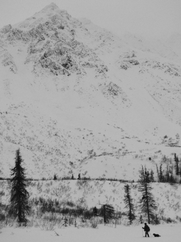
Snowshoeing along the lake with towering mountains overhead.
David May 10, 2025
We did this hike on the 9th May 2025. The trail is snow covered where snowshoes are needed. The views and atmosphere was superb. Found many scatters and footprints from many different animals.
Dave from Haines March 20, 2025
Did this walk several years when my doggie was in his prime. Such a beautiful place, well worth seeing.

Aaron Weber July 1, 2024
Hiked June 25. 1.5 hours of hiking, plus a stop at the lake. Benches at the lake are newer than in the photos. Trail is pretty easy.

Bonnie D. April 2, 2024
The trail was in great snowshoeing shape on Saturday, March 30th!!
Shailyn May 29, 2023
Did a nice overnight there (May 27th). Snow free trail but very muddy right now. One fallen tree to navigate around. Some fresh bear prints (including a baby bear), but we didn't see any. The lake was still frozen, so we carried the fishing pile for nothing haha.
Kathy July 5, 2022
We did overnight backpacking to St. Elias Lake, very nice and easy trip. A word of caution: If you decide to stay overnight make sure to keep your boots and backpack inside as porcupines are very active chewing your item left outside the tent.
Aces May 26, 2021
May 21, 2021- Still quite a bit of snow on the trails. we made it just over half way and decided to turn back due to improper footwear to trek through knee high snow through the valley.
Alastair Cook October 3, 2020
Our little group did this hike yesterday, October 2nd. It was overcast and threatening rain, but basically it held off, which we appreciated. We had done the hike five years ago, so it was something to celebrate again as a family.
To some folks it may seem a little tame, but at my age, 67, and energy level, it is ideal. The bottom line is you're out in the mountains in pristine wilderness and it's not about the quantity, it's the quality. The trail itself is well established and easy to follow, and it's nice that it actually ends at a lake with seating benches and firepit.
We all really enjoyed our afternoon. We saw a couple of groups of sheep high up the slopes, and at one point a very fresh berry laden pile of bear scat. Grizzly I think. Other than that, very quiet and peaceful.
Alastair Cook
Isabelle June 17, 2020
We did this trail today while being in Kluane Country. Very nice short little hike that doesn’t get boring as it changes a lot. Lots of ups and downs. We were following, from a safe distance a black mama bear and a cub that were eating on the mountain side. As we walked down the valley to get to the lake, it was nice to observe them. They were very far but close enough to know without a doubt they were bears! We had lunch at the lake, it is a nice little set up\ campground. We really want to come back and spend the night !
MJB October 15, 2019
I went to this trail on October 9th, 2019. There had been quite a bit of snowfall in this part of the Yukon on Oct 6th, and most of it was still remaining here. I found there was about 7-9 inches on the trail. I had snow boots on and that was helpful, but the traction was low due to the snow. It was a great hike, but because of the snow, it took almost twice as long as it would have without snow. I saw tracks from someone else who had walked the trail sometime between the 6th and 9th, but only one person's. I didn't see any wildlife other than birds. I did see tracks of what I thought were probably foxes. On the drive back to Haines Junction, I saw a few porcupines.
Stephanie March 29, 2019
Did this hike on March 26 and the trail had a good snow pack. The trail had some flooding/ice for the first kilometre. Just after the first kilometre mark there is a big flooded area. Unpassable. May have to wait a bit for this hike.
Liz B March 9, 2019
A group of 4 of us hiked this trail today (March 9th). The first 3kms of the trail are nicely packed and easy to walk on without snowshoes, the last km of the trail is looser; we fell through the snow a few times but still easily doable without snowshoes.
This is one of the easier Kluane hikes in terms of distance and elevation gain. The listed distance is bang on, 8km round trip from parking lot to lake. The listed elevation is 120m but it's actually closer to 240m if you factor in all the ups and down during the hike.
We saw two other pairs of people on the hike; this seems to be one of the less busy hiking spots. If the Ice Cave trail is too crowded for you I definitely recommend this one.
All on all this took us 4 hours. We took our time walking, made a campfire at the lake and sat around that for a while. This trail could easily be done in much less time.
Kyle September 24, 2018
Nice nature walk through the fall colours for about an hour.
Cata May 17, 2018
Did this trail today May 17th. Very easy, still muddy in a few sections of the trail. Takes about 50 mins one way. Lake still frozen...
Deb December 28, 2016
Did this trail on Dec 27th. It was -24. We left at 11 and were back at the car by 3:30 with 1/2 hr. lunch stop at the lake. We used snow shoes and had to break trail the whole way. I'm quite sure it's 4 kms. each way since there was a 2 km. sign approx. half way. It was a moderate snow shoe hike breaking trail. Very nice trip.
Alastair Cook August 30, 2015
My wife, daughter, and five year old grandson hiked this trail yesterday. It's a classic mix of walking through the trees, some elevation gain, but not too much, and the open panoramas towards the end, with towering mountains on each side at close range, in this case with some wonderful Fall colours emerging. It took us over a couple of hours each way, but my grandson was very intent on studying all the mushrooms that were in abundance everywhere, hence the longer time. We also spent some time at the little campground at the lake, and successfully made a fire. However, be advised there is very little wood to be had.
The going was very easy and there was no chance of getting lost as it is a maintained and well used trail.
A most enjoyable day out.
H. August 16, 2015
Walked this trail in late June. An easy hike that leads to a lovely alpine lake and campsite. Recommend renting the canoe that is stored there. Spotted fresh deer/moose prints on the return trip in the mud on the trail.
Ernie July 26, 2014
We hiked this trail a few days ago. It was a fairly easy hike with really nice scenery. One thing to note, it is not 4 km round trip, but 4 km each way. At a fairly relaxed pace with the kids and their grandfather it took us an hour in each direction.
Mel July 19, 2014
Did this trail yesterday and spent the night. First backcountry camping experience for my husband and my son (1 yr old) and we had a blast. The trail is really easy and the campsite was well maintained. We didn't have a problem finding dead branches for firewood, but I would suggest bringing a little hatchet. There was a dead tree that had been cut down near the tent pads that still had some bigger limbs on it.
We saw a mountain goat on the slopes above us (had the binoculars to confirm it wasn't a "rock goat"), and a beaver came out to make sure we were staying clear of his little lodge. Did some fishing and saw some Dolly Varden in the lake but couldn't get them to bite. Woke up in the morning to a valley full of mist. It was a great first time experience! We'll definitely be going back soon.
