
Total Distance: 9 km
Return Time: 3.5 hours
Elevation Gain: 618 m
Difficulty: Moderate
Region: Carcross
Traditional Territory: CTFN
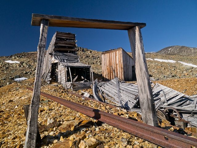
Follow this historic trail up into the alpine below Montana Mountain. The trail was originally made to service the tramway built in 1905 by Sam McGee for a silver mining operation. There are many remnants of the tramway and mining artifacts along the trail. The view from the top is fantastic, with Windy Arm of Tagish Lake below, and all of the surrounding mountains. There are a lot of deciduous trees here, so this is also a great trail to view the amazing fall colours. To extend this hike, you can connect to the Mountain Hero mountain biking trail, or hike up some of the surrounding ridges. NOTE: This hike falls within Category A Settlement Lands of the Carcross Tagish First Nation. Please respect their rules and land.
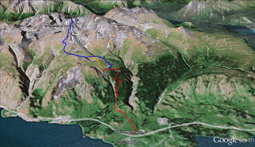
From Carcross, continue for another 17 km south towards Skagway, Alaska. Around this point you will see an old tramway on the left side of the highway. Immediately after the tramway, the highway will curve to the right over a creek and there is a gravel road on the left. Park at the top of the gravel road or just down the hill in a large gravel pit.
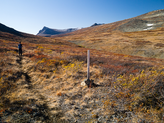
To get to the trailhead, cross the highway and walk down into the ditch. Walk along the highway to the north (right) for a few meters until you reach a wooden post with a small trail sign on it for the 'Mountain Hero Trail'. The path is clearly visible through the trees from this point.
Most of the trail is through the trees, but it is well established, fairly narrow, and varied in vegetation, making it quite a pleasant hike. Along the way you will see the old tramway, remnants from the 1905 silver mining operation where Sam McGee was the foreman.
The trail climbs at a good incline for most of the way. Not far up the trail there is a wooden bench that you can rest at and enjoy an open view through the trees of Windy Arm of Tagish Lake and the mountains on the other side of the lake. From here, the trail goes back into the trees, but opens up for more views higher up.
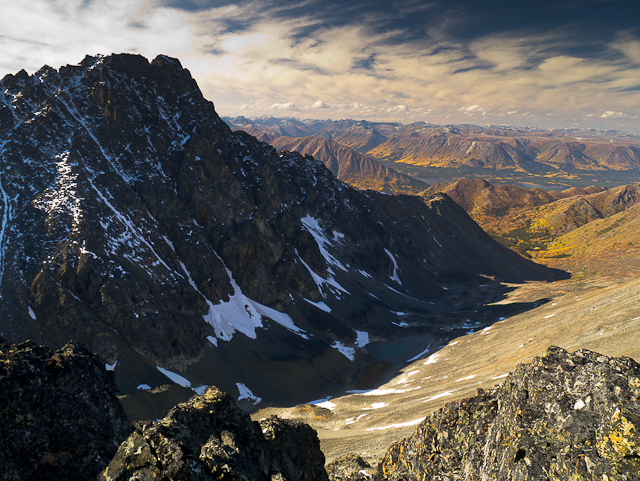
After 4 kms there will be a fork in the path. Take the left path, which goes another few hundred meters where you will leave the trees behind and get an expansive view down toward Windy Arm from the alpine. It also leads to an old outhouse and more tramway artifacts. From here you can follow the trail back down, or consider one of the extended hike options below.
EXTENDED HIKE OPTIONS
There is a lot to explore once up in the alpine, from continuing on the Mountain Hero trail as long as you like, or hiking the plateau to some alpine lakes (to the west), or even getting up onto a higher ridge between Montana Mountain and Mount Matheson.
To get back onto the Mountain Hero trail, you can go back down to the trail fork and take the right fork, or you can hike up into the alpine from the viewpoint and meet up with the trail. This trail continues all the way to the other side of Montana Mountain (see that hike for details if you want to combine these two routes. Note a second vehicle would be needed).
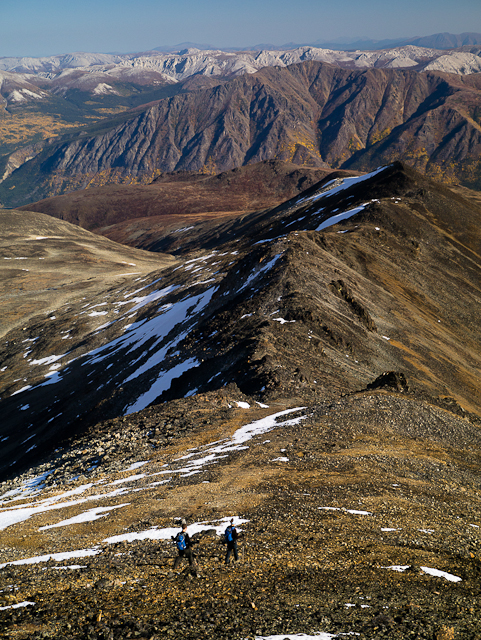
There are also many old mining roads that you can explore on the alpine plateau, one of which heads towards some alpine lakes to the west. To access a higher ridge above the lakes, follow the Mountain Hero trail until you can easily cross the creek gully (this is about 2 kms after that first fork in the trail back in the trees). Pick your way up the broad ridge as you cross an old mining road and come to another place with more tramway artifacts. Continue up the ridge, which should start to become more defined now. The first high point on the ridge is at an altitude of 1,957 meters, but you can continue up to the next high point at 2,069 meters where you will get a great view of Mount Matheson and even Bennett Lake. You should add another 4 hours (and 13 kms) round trip to hike to this point and back.
The main trail can be snowshoed in the winter. Depending on the popularity you may need to do a lot of trail breaking through the snow. Be sure to checkout the Yukon Avalanche Association website for their 'Avalanche Terrain Ratings' Maps - ATES (yukonavalanche.ca/ates). They have mapped this area. The trail through the tree line travels through 'simple' avalanche terrain. Once in the alpine you are in 'challenging' to 'complex' avalanche terrain, requiring much more risk management and avalanche safety knowledge.
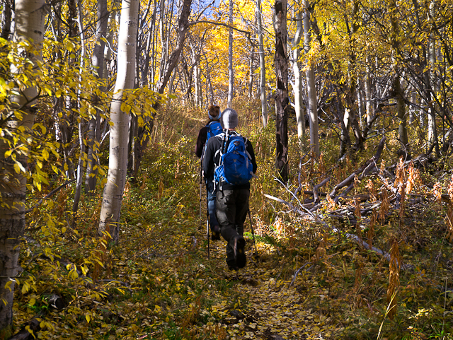
The trail starts gently through mixed aspen.
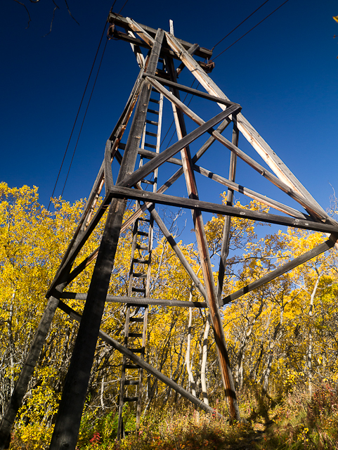
Old tramway towers are still standing along the trail.
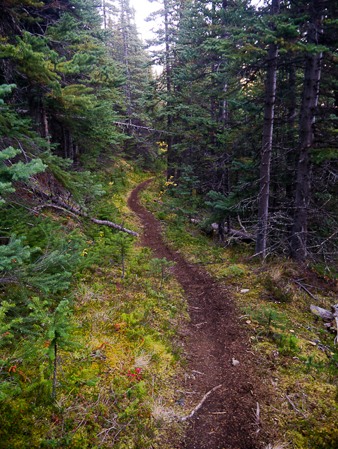
Even in the trees, the trail is well defined and a pleasant walk.

Up higher you get glimpses of the lake below and are back in the aspen forest.
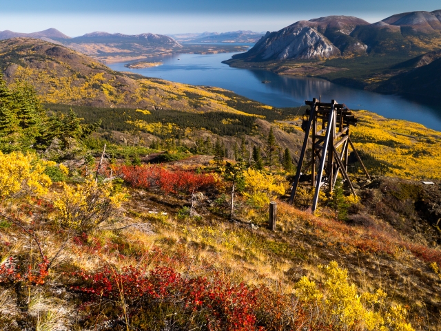
At the end of the left trail is another tramway tower and an expansive view of Windy Arm and the surrounding mountains.
If you take the right trail (or continue up from the left trail) you can take the Mountain Hero trail on the alpine plateau.
More mining remnants below the ridge.

If you decide to hike the ridge, you can continue along up to a high point at the very end of the ridge.
Mount Matheson and the mountains beside Bennett Lake from the high point on the ridge.
Descending the ridge, with a beautiful view to the east.
Rozie June 28, 2026
Hello, I am going to visit for the firs time in July with my family, we have two kids, and thinking hiking this trail to viewpoint. But I am a bit concerned what to do with kids if we encounter a bear, specially grizzly. Are there a meeting point to join other people before start hiking? I know there might not be too many people around. Any hint is appreciated. Thanks
MC June 5, 2026
Hiked trail on June 1, after KM 3, snow on trail to about knee length. Got to KM 4 but the snow really slowed us down.

Yukon Hiking September 19, 2025
Update on access, see photo.

Yukon Hiking September 16, 2025
TRAIL CLOSURE INFO:
Alpine Trail Access Closed Due to Bear Incident
Please be advised that there has been a bear incident on Montana Mountain, and there is reason to believe the bear may be injured.
C/TFN has requested that users avoid all trails accessing the alpine until Guardians and Conservation Officers can assess the situation. In the interests of public safety, the following trails/routes are temporarily closed:
• Access to the Mountain Hero Trail
• The Mountain Hero Trail itself
• The Brute Mountain and Sam McGee routes (as described in Yukon Hiking)
We also ask all trail users to exercise extreme caution on all other trails and to follow these important safety tips:
• Keep pets leashed at all times
• Carry bear spray and know how to use it
• Travel in groups and make noise
• Report any further sightings to Carcross RCMP
Beatte August 31, 2025
Wonderful day, no wind, blue sky!

Danial July 14, 2025
July 14, 2025
The trail is snow free from the base all the way to the top of the ridge with the exaption one small patch right after the look out point if you're taking the earlier route up. But the walk in the snow is another for a few meters.

Gabriella Rayo June 8, 2025
Bit snowy at about 550m elevation. Really beautiful though at the top!

Phil&Luisa September 15, 2024
We tried another “expansion” yesterday, which turned into a 2 for 1. When we arrived at the mountain hero trail (where the sign is), we turned left and went to explore the mining building and hike half way up the ridge high point. After, we tracked back to the sign and went to do Montana Mountain which is really close. Total hike was 25km (1,800m elevation gain), quite a long day about 13hrs but in the fall color it was incredible. For someone wanting a little shorter day hike with amazong view, when you get to mountain hero sign, turn right and go up Montana. Quite a challenge to do both Sam Mcgee and Montana in same day but totally worth it!!

EC May 21, 2024
Still a fair bit of snow on the trail past around 3.5km on May long weekend. Lots of punching through to our knees on the way up and slip sliding on the way down. Worth it, but probably shouldn't have left the boots and gaiters at home...
P.H September 17, 2023
did you lose your hat today sunday sept 17, 2023 on sam mcgee? we brought it into town, check happy hikers fb page for info.
Shailyn D August 29, 2022
Hiked on August 28th. Colours starting to change in the alpine for sure. Lovely day out, saw some goats and quite a few other groups on the trail. No recent signs of bears.
Cristina June 20, 2021
My friend and I hiked this trail on June 19, 2021 and we made it to the top.
It was a beautiful sunny and warm day! There were quite a few people hiking.
The trail was dry the first 3 km and then became a bit wet with some snow patches.
After the old outhouse the snow patches became bigger but not too deep.
It's doable with waterproof hiking boots.
Hiking poles were also very helpful on the way down (very slippery).
No wildlife sightings. Lots of beautiful flowers!
It took us 5 hours (roundtrip) but we spent an hour at the top enjoying the views and the sun.

Greg Shaffer January 24, 2021
23 Jan 2021 My 10yo dog Serah and I hiked the trail today, snowshoes definitely needed. I did a bit of pre-planning / prep to make sure I could find the trail...Trailforks app following Mtn Hero (Biking) helped, not sure why all these trails cannot be found on that app?? Started at noon and returned around 1700 with several stops along the way. Not the greatest weather for views but still was worth the effort! Several areas along the trail had evidence of small snow slides and snow falling from the larger trees made it a bit more challenging. The end brings a tough decision to continue going further / higher...if I didn't have to break trail I would have had the energy. Return hike is super fast!

Monika July 6, 2020
I was just there yesterday 5th July 2020. The trail was super easy to find and follow. We did stop few times to enjoy the views so going up and down took us around 4 hours. I was surprised how many people actually were on the trail we counted around 13-15 lots of them families with kids. There was no sign of bears or other wildlife and luckily no mosquitoes either. It was very enjoyable hike im definitely coming back in fall!

Jan Burks June 22, 2020
Trail in great shape but I lost my Arctic Winter Games Volunteer vest and cell phone on the way down.
Please let me know if you find it
thanks
Henrick leclerc April 13, 2020
WOW I love it I did it 3 times
Christine August 31, 2019
Hubby and I hiked this two days ago. We are avid hikers and found the trail very enjoyable and not all too challenging. There is a bit tree that fell and hour up the trail if someone has a chainsaw. The view at the top is very stunning. We recommend doing the extra trek to the alpine as it really isn't that far and totally worth it. We brought bear spray but didn't see any indication of any. Very pleasant hike.
Paula Pawlovich June 22, 2018
Hiked the trail last night to celebrate Solstice. 4 grizzlies on the hillside where trail leads to towers (end of red trail). Start of blue trail is wet as melt or creek is meandering down trail. We turned around. Also - steaming fresh bear scat - on the trail heading back down. Make lots of noise. Gorgeous views.
Katarzyna Nowak June 21, 2018
Hikers using this trail also seem to use the old mining road a little further down the Klondike toward the B.C. border. A local person advised that Yukon Hiking and other such websites please advise that a sign be strategically placed along this mining road delineating the dates of the mountain goats' kidding period (at least May 15-June 15) so that hikers (especially with dogs) are more sensitive about this, ideally avoiding the area altogether during this time.
David May 21, 2018
I did this trail May 19th. Patches of snow after 3km but it's not that bad. I went to the top. Sometimes you don't have any chance to avoid the snow, need waterproof shoes :) After the forest there is more snow but you can go the top even if you have to cross some part where there is more than 40cm of soft snow. Should be awesome in 2-3 weeks

Jackie H May 6, 2018
Climbed May 6. Trail was dry and clear up until the wooden seating area/outhouse mentioned in the description. Still quite a bit of snow on the trail higher up than that (when it gets into the evergreens).

Louise and Gus September 19, 2017
Did this trail for the first time on Sunday. Weather was a bit cloudy and drizzly but not too bad. Look for the gigantic wooden thing on the side of the road going towards Skagway, and the trailhead is just past that on the opposite side down in the ditch! The first bit is relatively easy, but watch for old mining cables going across the trail at feet and head level! The trail gets narrower and steeper and I had to stop a few times to catch my breath. There are wonderful views at different points on the way up. You will eventually come to a switchback to the left where the trail will level out and you will be relieved (or I was!) after a few hundred yards you will come to the fork. The right fork goes up, but the left fork stays level and I took this one and came to the mine workings and outhouse, with the most incredible views. It took me an hour and a half to get to that point, and an hour to get back down. No sign of bears at all. Looking forward to doing this one again!

CKLMSimons July 29, 2017
Did an overnight trip on July 24/25, 2017. This was our "shake down" hike in preparation for the Chilkoot in a couple weeks. Full packs for the four of us and it took 3hrs to get to the alpine only 2hrs to descend the next day. Absolutely amazing views when we hit the alpine. Weather was perfect. Had dinner at 8pm and a bull caribou (300m away) was our entertainment as we ate. Great memories! Thanks Sam McGee!!!

Yukon Hiking July 6, 2017
Please note that the alpine areas of the Mountain Hero/Sam McGee Trail are within critical post-calving habitat for the Carcross Caribou Herd. If you come across any caribou (or other wildlife for that matter), always keep your distance, giving all wildlife a wide berth, and keep any dogs on leashes or leave them at home... they won't know what they are missing!
Kyliestravel June 30, 2017
Hiked this trail on Sunday 25th, a pretty easy going hike, you are mostly in the trees (bit humid) but get some clearings on the way up. We hiked just to the area with the old mining site and back down. The views are pretty amazing once you get there.

Kyle June 28, 2017
Beautiful Trail!
Some bear poo though mid trail so bring some bear spray.
Took me an hour and a half to get to the summit and an hour
down back at the starting point (beginner hiker).
Lots of other mountains to explore and snoop around once
you make it to the summit.
Little bit of snow at the top in tiny patches with an outhouse at the top.
Shannon W June 28, 2017
A group of 10 of us hiked the Mountain Hero trail yesterday. The trailhead is marked Mountain Hero and not Sam McGee as noted before. We crossed by some bear scat on the trail about 3 KM up. There was one small snow crossing just before the second rise and up by the ruins. We saw a beautiful bull caribou grazing and some goats. Bring binoculars to spot the wildlife. We departed at 9:40 and returned at 7 with a lunch break at the first summit.

Rozie May 31, 2017
Visiting Whitehorse and hiked this trail on May 28th and the directions to the trail were great. Once we were on the trail it was clear and easy to follow, although we couldn't tell where the 4km fork was. We found an amazing view but no outhouse.
There was still snow in patches within the trees and a little before the trees ended there was quite a bit of snow on the ground. Some other people that morning, as well as days prior, had packed a bit of a path but at some points it was knee deep. We didn't make it to the high points on the ridge.
The trail was signposted "Mountain Hero" from the road, and according to that sign this is a moderate hike which I'd agree with - there is quite a bit of elevation and the constant uphill isn't easy.

Taibhsearachd May 20, 2017
We hiked the trail earlier today. We didn't make it to the very top because there is still a fair amount of snow up high and we had not thought to bring snowshoes. This gives us an excuse to return later in the summer. It is a lovely hike and we loved seeing all the old artifacts. No sign of bears on the trail.
Because you are pretty much climbing the whole way up, I would categorize this as medium in difficulty and not easy as is suggested by yukonhiking.ca. Hiking poles would be useful on this trail.
Anthony March 26, 2017
Went up March 25 on skis. We followed a good snowshoe track about half way to treeline, then a narrower bootpacked trail until the last couple of switchbacks just before reaching the alpine.
We carried on to the Montana Mountain summit and then skiied back to Carcross. Great snow conditions.
Andrew January 8, 2017
Hiked Sam McGee Trail on Jan. 4. Trail was packed down most of the way but snowshoes were definitely needed at the top where the snow was waist deep in places. Four and a half hours round trip with 20 minutes at the top.

T&C November 30, 2016
My husband and I did this trail today for the first time. The view was gorgeous. It was great to have little sneak-peeks of the view along the trail. There was about two feet of fresh powder on the upper switchback part of the trail - snowshoes were a must! The first chunk of the trail is a nice, easy, winding gradual feel, but as you get into the switchbacks, we would say that with all that snow it is more moderate/difficult. The view is worth it :)

Erin Giesbrecht September 27, 2016
The sign at the trailhead says "Mountain Hero"
Dagmar Rudzewitsch September 13, 2016
Still on of my favourites ...

Steph September 5, 2016
Great views on a beautiful September day.

Alastair Cook August 28, 2016
Saturday, August 27th was a great day to be on the Sam McGee trail, a beautiful mix of sun, cloud, mild temperatures and fall colours. There were quite a few people hiking, which was good to see. The sad side of things was the recent passing of Wayne Roberts who was responsible for the trail being what it is today. We all owe a lot to the pioneering work of others. What a great legacy he left, something for us all to enjoy for years to come.
I also found a small knife and black case on the trail. If anyone happens to read this,who knows the owner phone me at 456-4397.
Ellie, Laura & Vanessa May 26, 2016
Drive past Carcross going south towards Skagway on the South Klondike Highway. About 17km after passing Carcross you will spot a tramway ruin on the left hand side off the side of the road, continue driving a few meters to a pull off on the left hand side of the road, where you will be able to park in an open area. Once you've parked, cross the road and down into the ditch, where you will see a trailhead post down to the right. This trailhead post is the Moutain Hero Trail.
The first two kilometres are following a well marked trail through the forest. You will come across a few tramway ruins before coming to an opening and bench area looking out at the Windy Arm about 2kms from the trailhead. After this look out area, the incline of the trail becomes more steep as you climb the mountain.
From here, continue along the trail another 2km (4km from trailhead). Here, you will come to a fork in the trail where you are given the choice to go right or left. We continued left for another 1.5km and we were able to see old ruins of what we thought to be housing locations for mine shaft workers. Continue until you come to a second fork in the trail, and keep left again for another kilometre where you will reach ruins of an outhouse and more tramways. It was safe to explore around the ruins and great views of Windy Arm and Tagish Lake are beautiful from above the tree line.
It is possible to continue up and explore around the area. We experienced all weather conditions such as rain, hail and snow, but it was an amazing hike with plenty to see along the way!
No dangers of bear sightings. About 6km from trailhead to highest tramway ruins and we completed this hike up and back in about 4 hours, stopping plenty to take photos and explore the tramways.

Fred April 4, 2016
Heads up to anyone looking to hike this trail in the following weeks. Snow is melting up there making an incredibly trudgy hike. You will be dropping up to 3' on some steps. IMO snowshoes still absolutely needed for higher regions in combination with waterproof shoes.
Alastair Cook March 19, 2016
A friend and I hiked up to almost the top of the tree line today. A couple of inches of fresh snow, but didn't need to use the snow shoes we brought. Great hike. However, I had my snow shoes (blue Tubbs)strapped to my back pack. I didn't realize till I was home, amazingly, that I no longer had them. They had to have fallen off somewhere on the way down. If anyone sees them, could they please contact me at 456-4397. It's a long shot I know, but this seems an appropriate place to advertise the fact. Great hike though. We were out for about three and a half hours.
Anthony February 22, 2016
On February 20 we skied up the trail and then followed the old mining roads back to Carcross. There is a bomber snowshoe track for the first few km and now there is our ski track to follow to the treeline.
Christine January 26, 2016
A spectacular trail in great conditions, it's not as define once on the plateau but it does not matter. Views, close and distant, in all directions fabulous!

Stephen K September 26, 2014
Wonderful trail! It felt like it must be at its very best towards the end of September (hiked yesterday, the 25th) with the deciduous trees turning colour and losing some of their leaves. Great views, nice climb through different ecozones, interesting artefacts from mining days. I'd call this trail "easy" in the sense that it is nice and smooth--few rocks and roots or bad steps to take--and very well maintained, but the climb is pretty relentless, and if this kind of grade rates "easy" then the average Yukon hiker must be part mountain goat. Well worth the effort, all the same. Hiking poles were good to have for scrambling the really steep bits above the trees and on the descent. You won't be disappointed.
Inga August 14, 2014
We hiked this trail in early July in perfect conditions. We connected it to a scramble up to the summit of Montana Mountain, so got to traverse various eco-zones covering about 5,000 foot elevation - according to my altimeter - and a couple of remaining snow patches. As we took the detour via the tramway which meant a bit of a bushwhack up to the plateau we took close to 6 hours from highway to the summit. The hike down was much faster at about 3.5 hours (summit to highway). (Times include breaks, lunches and time on the summit). We enjoyed clear views from the summit and loved the evening sun accompanying the descent. The only people we saw all day were a group of 3 mountain bikers around 10 pm descending on Sam McGee (Mountain Hero). Great day.

H&C July 31, 2014
This is the second time I went on the trail. It took 1.5 hours to the top (where the last wooden structure was) and from there we climbed further to the top of the mountain and walked left, across the top. Saw tons of goats and the scenary was amazing!
Terry Joss June 28, 2014
This is one of my favorite trails. Well maintained, easy to find, and you can explore forever. Highly recommended. Bring a camera, wildlife in pooley Canyon, Sheep, maybe a bear who knows, but the scenery is amazing.
Bob June 23, 2014
Hiked up June 21st. The trail to the treeline is in great shape with only a little running water in places and took 90 minutes going steady. Lupine are everywhere in the alpine. Hiked up above the mine workings to ridge between Montana and Matheson Mountains which took another two hours. Needed to cross a few snow patches but not many. The ridge is awkward with light hiking shoes; boots are better. Very windy on top but great views. Didn't see any bugs all day. Only saw two people all day and no bikes. Took 8 hours with lunch and about 15 km with 1300 m elevation gain. Lots of hiking options in the alpine.

Arica June 6, 2014
Great trail. We took our two boys 5yrs and 3yrs... A little steep for the three yr old in places but there was a bit of snow on the trail that kept them running from one patch to the next. Too much snow to actually summit but a great day.
Sophie September 8, 2013
Wonderful hike with the fall colors! The trail is easy to follow and the slope is really progressive. Perfect trail for families or beginners.

Alastair Cook August 19, 2013
Some friends and I hiked the trail yesterday. Wow...this is everything I enjoy in a hike...going up into the mountains, a good path,views everywhere, historical artifacts to see,and manageable even for an older fellow such as myself (60). I'm always curious as to how the time is designated for these hikes. It says three hours for this hike, but if that's both ways, and for the whole trail, then you must be running. We stopped a fair bit, but even so, I would have added an hour or two onto your three your posted time.
Either way, one of the best hikes I've ever done.
Genevieve September 26, 2012
I have hiked this trail many time and never got tired of it! It's beautiful specialty in the fall. Once on top, if you are lucky you will see goats on the north side of Conrad Creek.
If you want to know more about the history of the mine,I recommend the book "Fractured Veins & broken Dreams"

Anthony September 26, 2012
Mountain Hero is a popular mountain bike trail so if you hike it, try to keep your eyes and ears open for riders coming down. We always try to yield to hikers but, as the trail is quite steep and grown in, chances are you will hear us coming before we can see you.
This is one of the Yukon's best trails for hikers or bikers. The combination of views and silver mining history can't be beat. Glad to see it listed!
