Total Distance: 29 km
Return Time: 15 hours
Elevation Gain: 1950 m
Difficulty: Very Difficult
Region: Kluane
Traditional Territory: CAFN
UPDATE 2022 - THE START OF THIS ROUTE VIA THUNDEREGG CREEK HAS BEEN WASHED OUT - SEE ROUTE DESCRIPTION.
Mount Archibald is the highest point in a group of mountains between the Dezadeash River and the Jarvis River. The southeast ridge is an interesting scramble with views of surrounding glaciers. The summit offers a view down into the Kluane Icefields, including Mount Logan. This hike is rated very difficult due to the exposure, scrambling and distance.
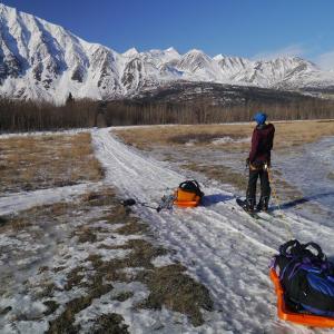
From Haines Junction, continue north on the Alaska Highway for 10.5 km. Take the left immediately before the Bear Creek Lodge. Note that there is a Kluane National Park sign 2 km before this turnoff that mentions the Alsek Trail. Follow this road for about 750 m until you reach a large parking area and some Parks Canada signage for the Alsek Trail.
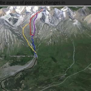
If you have a 4x4 vehicle with high clearance and the water levels aren''t high, you may be able to continue past this point and drive all the way to the cliffs at Thunderegg Creek. Driving to Thunderegg Creek will save you 14 km (and 200 m elevation gain). See the description for Thunderegg Creek for directions.
Notes: This route is for the southeast ridge. It is a long hike and is recommended as an overnight trip with camping in the alpine. Also if there is snow covering the ridge, you may require crampons, ice axe and rope. Much of this beginning of this route is within the Kluane Wildlife Sanctuary and not in the National Park.
UPDATE 2022 - THE START OF THIS ROUTE VIA THUNDEREGG CREEK HAS BEEN WASHED OUT AND THEREFORE THE FIRST PART OF THE APPROACH NO LONGER APPLIES. SEE THUNDEREGG CREEK HIKE FOR RECENT ROUTE COMMENTS.
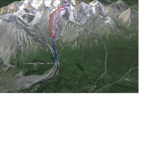
From the cliffs at Thunderegg Creek, you have 2 options, depending on the time of year. If the creek is frozen (early Spring) or relatively dry (late Autumn), then you can descend down to the creek bed and follow it upstream to the dry stream bed that leads to the alpine (more on this below). Following the creek bed would eliminate most, if not all, of the bushwhacking. Do not attempt to follow the creek if it is running. Not far up the creek there is a narrow choke that is impassable if water levels are even slightly up.
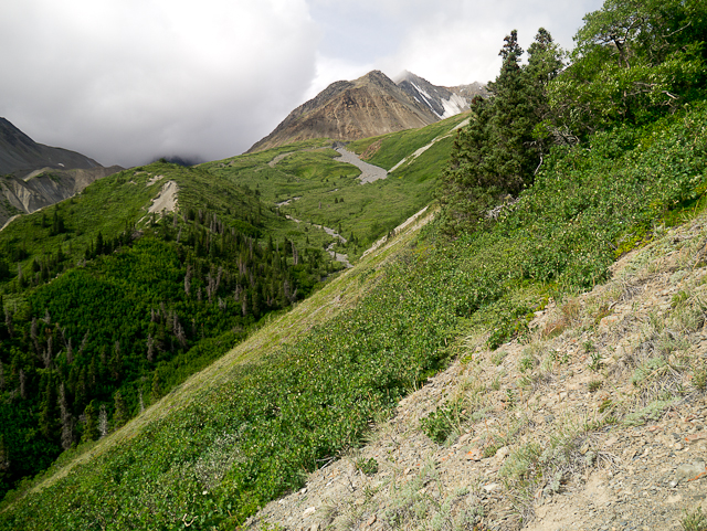
If Thunderegg Creek is running, then you have to reach the dry stream bed by bushwhacking to it (this is the blue line in the map above, and is 3 kilometers one way). Continue following the ATV trail past the cliffs at Thunderegg Creek. The ATV trail eventually turns into a walking trail, with minimal amount of bushwhacking. The trail ends after approximately 600 meters at a small fire pit with a grill. There is a small stream just ahead, through the bushes. This is where the serious bushwhacking starts in earnest, but shouldn't last more than an hour.
Cross the small stream by stepping on any trees that span across it. There will be a hill in front of you at this point. Start bushwhacking upwards and slightly to your left (stay on the Thunderegg Creek side of the hill). You are aiming to get diagonally to the top of this hill, but not right away. Once you reach the top of the hill, there is some more bushwhacking, but you may find reprieve on the right (north), steeper side of the ridge if you find the animal trail. Either way, continue up the ridge until you leave the bushes and can see above you again.
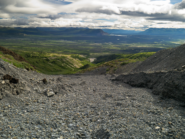
From near the top of this ridge where the bushes start again, you want to descend to the dry stream bed. You should be able to see the stream bed meandering up into the alpine. Descend from the ridge to a point where you can see the dry stream bed. Don't worry if you have to bushwhack for a few meters up the stream bed, as it is much easier than what you just came through. It will soon open up into a wide, gravel creek bed. Follow the dry creek bed all the way up into the alpine.
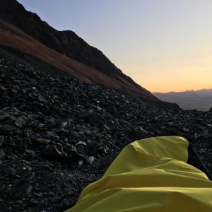
If you are spending a night or two (recommended) up here, there are plenty of good camping spots up in the alpine at the top of the dry stream bed. Water is available a short walk to the north, where you can descend the moraine to a stream.
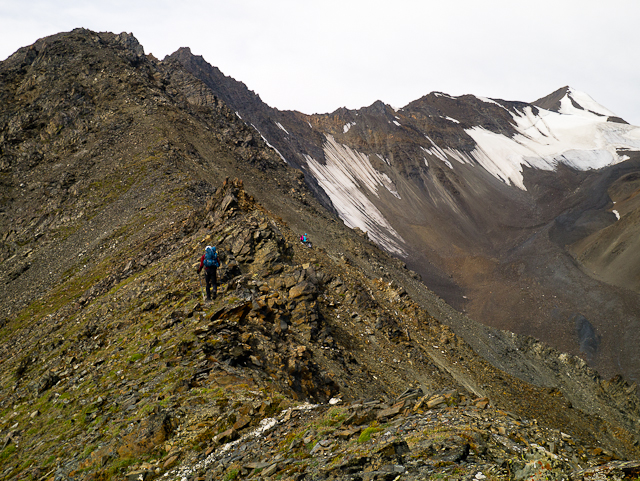
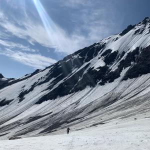
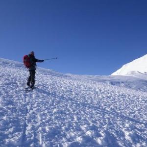
Now you have to gain access to the southeast ridge (this is the red line in the map above and is 4.8 kilometers one way). From here, scramble up the slope closest to you. It is steep but hike-able. Once you gain the top of the ridge, it widens out for the first part and is an easy walk. You will be sticking to the left (south and west) side of the ridge most of the way, as it is a much gentler slope than the right side. Unfortunately, it is often the windy side of the ridge.
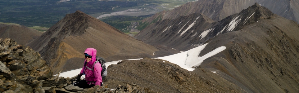
The ridge is straight forward and easy walking up until the large sub peak, which is where the ridge turns slightly more to the north (right). You will have to go up and over the sub peak, which will involve a very short section of Class 3 or 4 scrambling. Climbing up this is the most exposed part of the route, but once you climb over the sub peak, it is less exposed on the other side. Descending this part is more difficult than ascending it. You might opt to bring a rope for this section, although there isn't much natural protection around to anchor to.
After the sub peak, you will be side-hilling and scrambling along the ridge, trying to avoid most of the ups and downs. You may be required to use your hands. This Class 2 or 3 scrambling continues for a while until you reach a rounded shoulder before the main summit pyramid.
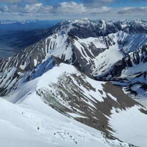
The summit pyramid is now an easy scramble to the top. There is a glacier on the northeast side of the ridge, so continue sticking to the left side of it as you make your way up to the summit. At the top, you can continue for a few more meters to reach the true summit.
The views from the summit are incredible. There are many glaciers in the valleys below you. To the southwest is the Alsek River and Dusty River, meandering through the mountains. Directly west is the Kaskawulsh Glacier. You can see further west into the Kluane Icefields, including Mount Logan.
On the way down, you can try to descend by one of the scree slopes rather than hiking back all the way along the ridge. This may not save you much time, as the scree slopes are steep and send rocks tumbling down everywhere. If you want to descend one of the scree slopes, wait until after you are back down from the sub peak, as the slopes are very steep up higher along the ridge. Be aware of potential changes in creek levels on your way down.

Bushwhacking! Not fun, but should only last about an hour.

After bushwhacking upwards, you should aim for the top of this open ridge.
The grey, meandering dry stream bed is what you are aiming for, as it will lead you to the alpine.
Looking back down the dry stream bed from up high.

Lots of places to camp in the alpine.

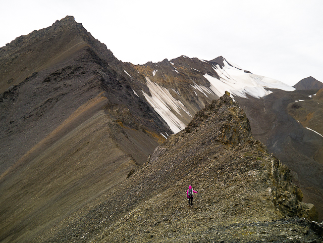
Approaching the southeast ridge.

Scrambling up to the top of the ridge. It widens out for the first section.
The ridge starts to get rockier and more narrow as you climb on. The summit is on the far right.
On the left is the subpeak. The only exposed spot is getting up and over it.

Climbing up and over the subpeak. Note the dropoff on the bottom left.
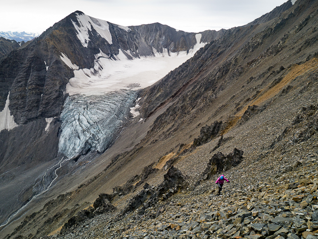
You'll get beautiful views of glaciers along the way.

The summit pyramid.
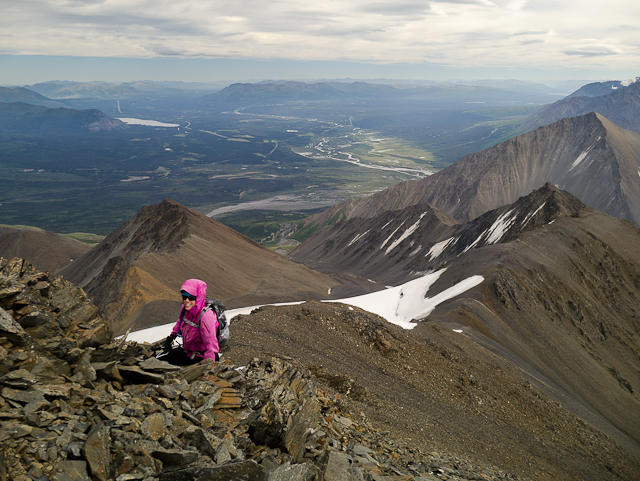
Approaching the top near the summit with a view of the southeast ridge angling to the far right.

The final steps to the summit.
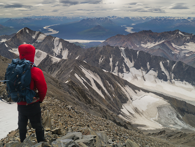
Looking towards the Alsek and Dusty rivers from the summit.

Cai July 23, 2025
So nice to have the willow tunnel and cleared trail. No bushwhacking. Incredible changes in water levels from day to day and morning to evening. The creek by good camp was dry no water flowing on the evening of July 20th and flowing July 21st still easily crossable.
Between the sub peak and peak was a water source which we were grateful for.
Simon September 19, 2024
As of September 2024, trail has been re-cleared after the fire pit! Very easy to follow a well traveled footpath through a trimmed jungle of alders. Once you start climbing up onto the bare ridgeline, there's a point where you contour down left to the end of a wash, marked by a large cairn. From there, head straight into the alders and there's a trimmed back tunnel that eventually proceeds to wider terrain. No bushwacking required, if you end up bushwacking it means you've went the wrong way ;)

JP July 31, 2024
End of July 2024. Amazing hike. Observations that could be useful to others. Thunderegg creek was completely dry, both on the way in and out, super easy to walk up the stream bed until it reaches the old exploration road that brings you to large silt cliff where the thundereggs are. The bushwhacking part, after the small fire pit, really important to follow the instruction described on Yukon Hiking « Cross the small stream by stepping on any trees that span across it ». There seem to be a trail to the right of the fire pit that is more accessible with blue flags, but this doesn’t take you where you want to go, so cross the small stream over fallen trees, and even if the vegetation is really overgrown, there is a path, easier to see by looking on the ground than through the trees. There is a cairn by the forest down below, visible from the open ridge, that indicates a good entry point to the dry stream bed.
Stayed overnight in « good camp » spot. Beautiful spot! The nearby creek described to refill water close to camp was completely dry, but in the same direction, just about one more hill over, down a valley there was another creek running, clear water. Nothing more to add from there on, followed the classic route for the rest and came down a scree slope past the sub peak which was easier than returning the exact same route back.
CM September 14, 2022
Someone put up Cairns (came across them earlier in the summer) and also attempted making a fire pit at the basecamp spot (which is too windy for a fire most of the time anyways.... there is also no wood up there so...why?). Just a reminder to keep things wild, folks! This isn't your average hike- it is legitimately very difficult and that's why people attempt it :)
Tom August 4, 2022
Attempted on July 21st 2022.
Thunderegg creek portion of the approach is washed out and traversed by creeks. See that page for more details.
The trail from the end of the ATV trail to the open ridge is surprisingly open. It's steep but easy to follow; someone had recently cut back some of the brush. From the open ridge we were unable to find a path through the brush to the streambed.
Brando August 22, 2020
I absolutely must bag this before the end of the season! No exceptions lololol
Daniel July 6, 2020
Did it the weekend of July 4, 2020. We took the route described below by Verena (marked in purple). Almost all the way from the camp in the alpine to the peak the route was covered with snow. We had our snowshoes which is fine when you hike up, on the way down through the steepest sections the crampons would be better. In the afternoon the snow in some parts was very soft and a meter deep. When travelling through the valley to the saddle keep an eye on rolling stones from the southeast ridge, on the way back we registered one bolder cut our track from the morning. The views are phenomenal !
Foresty June 13, 2020
June 5, 2020. Rode my bicycle up to the end of Thunderegg Creek. Took about 12 hours total roundtrip. Lots of snow up there, crampons and ice axe came in handy. Fun route and good views!
Marc September 9, 2019
Picture of the bivy in the middle of the rocks trying to reach the ridge. (Not ideal place to camp, and you can hear rocks falling down around you during the night).
Can you spot the 3 mountain goats I woke up to!??
Marc September 9, 2019
Nice hike!!! Ridge was not snow covered this weekend. I was surprised to see nobody else up there on this beautiful weekend. Was all alone!!
In the MOST IDEAL conditions, this was a 15-hour hike for me. That purple line to be clear would not be possible at this time of year. Not even close. If snow covered, then somebody might consider it with proper equipment. I took the yellow route and thought it was the best.
It didn’t really make sense to me to follow an unstable up and down ridge for that long. So that’s why I kept following the creek by jumping over it when I needed to cross. Why not just follow the creek until you reach the ice caves, and go straight up from there to catch the ridge halfway. Shorter distance, and less time for sure. The scrambling from the creek up to the ridge wasn’t easy, but very doable because there’s a small depression that leads to it very easily. And many sheep trails to follow up!!! However you won’t see one section of vegetation to camp on, so I ended up setting up my bivy right in the middle of the rocks in a flat spot. So a better way up for sure, but not the most ideal campsite.
With all that being said, and again in IDEAL CONDITIONS, most of my clothing is ripped because of all the rocks that were loose that you end up tripping on. A fall could be fatal here. Lots of scrambling, and my body is full of bruises / scrapes from the loose rocks. You just never know if it’s a good grip or not... And sometimes the biggest rocks that look like they aren’t going anywhere will end up being loose, so be careful.
View : Nice view, but not the best for the effort! Why not a Kings Throne that demands 1/3 of the time and less effort for a better view?
brodapper July 10, 2016
A buddy and I did this, this weekend. (july 8-9) The drive in was interesting as the rain turned the road into a creek for at least a km. On the way out it was wet but not running. We hiked to alpine spent the night, woke up early then did the ridge. Once up and over the described sub peak we followed the ridge until the last sub peak before the summit pyramid. We opted to drop down to climbers right and put on the crampons to cross a snow slope to avoid more talus side hilling. We gained the ridge again and continued onto the summit pyramid. The summit pyramid still had lots of snow so we opted to put on the crampons again and short roped the last bit to the top. It was cloudy and windy but amazing! On the way down we followed the ridge to a snow ramp (Verenas route?) and dropped down to the valley, folowing it all the way to camp, then down to our truck at thunderegg creek. Someone has marked the bushwack by cutting bark off trees. It was helpful on the way down. (Thanks!) An amazing adventure.
Stephan March 23, 2016
This is a great ski mountain. Pulked in from the parking lot to just below Thunderegg gorge, stayed overnight and skinned past the gorge and up the dry creek entering Thunderegg Cr. from the North. We were able to get through the brush without taking skis off by staying in the creek-bed which soon turns into a nice gully. (This is also the best approach for summer that I have found.)
Basically following the route that Verena describes below (thanks, Verena), we got to the saddle just below the summit pyramid, left skis+board and booted up to the summit. Views to Mt Kennedy and Mt Logan were phenomenal. Watch out for barely buried rocks on the way down.
Verena July 3, 2015
our alternative route in purple
Verena July 3, 2015
Amazing adventure, we went up the valley instead of the ridge.. steepest part was 30 degrees, the lookers left of the snow field is almost ice free (I was poking a lot with my probe), but if its later in the season and the snow is harder, crampons would be nice.. however, no crevasses or ice the way we went up (still south eastish), definitely possible to skirt around the ice.. easier than I thought and way less steep than it looks, once we were up on the col of the peak, we took the ridge the last pitch to the peak.. The ridge looks like a way nicer, and interesting climb, our route seemed a bit easy and straight forward..thanks for the detailed description...
Marko Marjanovic March 6, 2015
We tried climbing Mount Archibald last weekend. We intended on skiing most of the way from the highway up into the alpine. However, with such low snow levels and above freezing temperatures, there was almost no snow at lower elevations.
We carried our skis on our backs to Thunderegg Creek. Skiing up the creek was a challenge since the creek was open and flowing.
Up high, the snow was hard and icy. We setup camp in the alpine, knowing we wouldn't be climbing the mountain the next day.
We ventured up the moraines the next day, and the spindrift coming off of the summit reinforced our decision not to climb this time.
JP June 23, 2014
Hi!
Anyone (experienced hiker/climber) would like to ascent the summit this upcoming weekend (June 28-29) ?
