Total Distance: 2 km
Return Time: 1.5 hours
Elevation Gain: 250 m
Difficulty: Moderate
Region: Whitehorse
Traditional Territory: KDFN, TKC
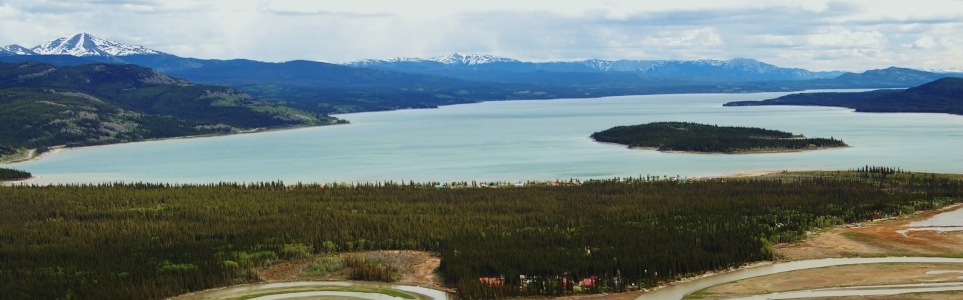
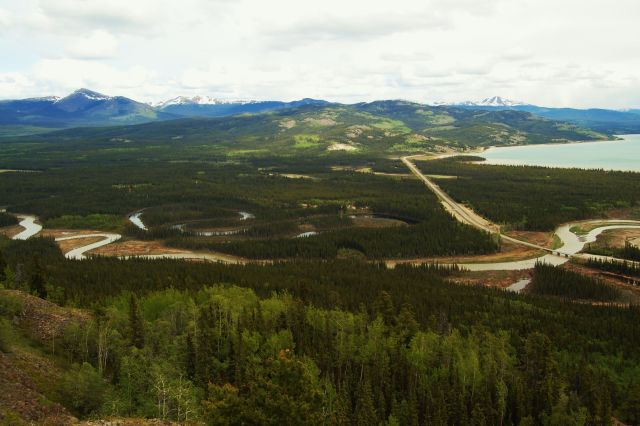
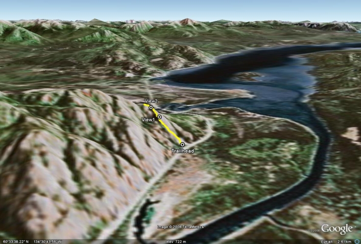
This is a quick day hike that provides a panoramic view of Marsh Lake, the M'Clintock River, and the Yukon River. Mount Lorne can be seen directly across the valley. There is a very steep trail to the first viewpoint, and then not much of a trail after that, so use your own route-finding skills. NOTE: The M'Clintock Ridge area falls within Category A Settlement Lands of the Kwanlin Dun First Nation. Please respect their rules and land.
From Whitehorse, drive south on the Alaska Highway. After crossing the bridge over the Yukon River (beside the Lewes River Dam), drive for another 9.2 km until there is a small dirt road and gravel pit on the left. Turn onto this road and park in the gravel pit. This turn off is just after a sign for Swan Haven. Note if you reached the M'Clintock River Bridge you have gone too far, the gravel pit is about 2 kms before the bridge.
From the base of the gravel pit, walk straight up the pit to the opposite corner. Or, if it is boggy, follow the obvious truck trail for a couple hundred meters and walk across to the other end of the gravel pit.
Climb up to the trees and look for a small trail. This trail meanders up the hillside to the first viewpoint, and at times may not be visible for short intervals over rock. It is very steep at times.
After the first viewpoint, the trail somewhat vanishes. Stay along the edge of the rock face and scramble up a small rocky area to the second viewpoint.
From here, you can head back down after enjoying the views over Marsh Lake, or you can continue to explore a little higher up the ridge.

Following the trail through the trees from the trailhead.

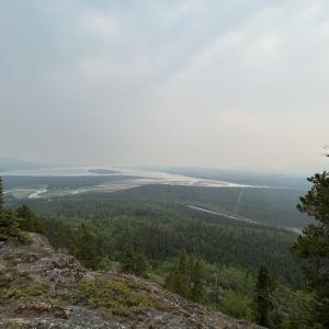
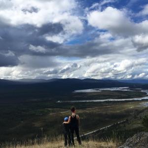
The first viewpoint overlooking Marsh Lake.

Marsh Lake and the M'Clintock River.
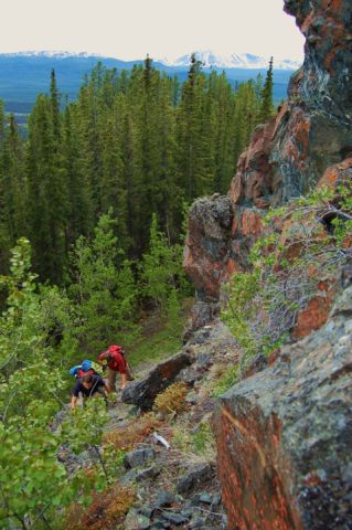
Climbing up the thin ridge to the second viewpoint.
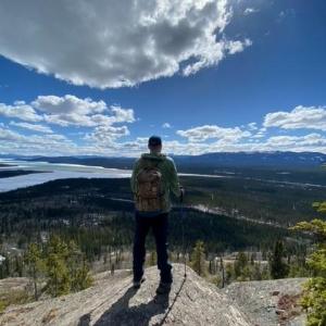
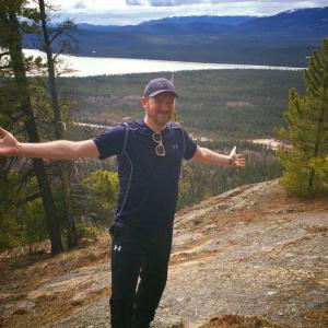
The second viewpoint.
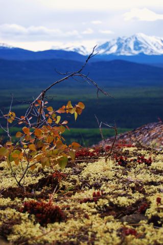
Colorful lichen with Mt. Lorne in the background.
Al June 14, 2025
Although a smoky day, good day for a hike. Views still very nice. Just a different look with the smoke.
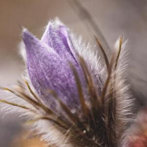
Crocus April 21, 2025
Instructions are not good. Very important details are left out and can make you start at another location. It’s more 7.5-8km after the blue Lewis bridge and on a straight hwy stretch. It’s basically an immediate left from the Swan Haven sign. Gravel pit is old news as it’s over grown now. NOTE about 1.5km further down the road which led us to the 9.2km originally spot is another gravel pit and Swan Haven sign. This is NOT the spot. If you’ve driven past the straight stretch hwy and have taken a tight left corner you have gone too far.
Shailyn June 7, 2024
I headed up here for a mid-week hike after work on June 5th. The trail was in great condition (no snow or mud), and there were no signs of wildlife. Tons of beautiful wildflowers, including my favorite - mountain forget-me-nots. We only went to the first lookout - 1.1km return with 190m elevation. Always glad to have my poles on this hike.
Shailyn May 3, 2023
Hiked this on May 2nd with a group. I believe we only got to the first lookout as the return trip was only 1.1km.
Neat little local hike and a solid effort up. A hiking pole recommended. No problem skirting around the wet section. Some snow still on a section of the trail that made for a slippery descent. Nice to finally do this one. No signs of wildlife other than swans and some other birds.
Mattie James June 26, 2022
Accepted the challenge of this steep, short hike yesterday - June 25. Guidance provided by this site is pretty much bang-on; thanks!
I walked the road around the pit, as the area through the old quarry was still quite muddy & wet. (Takes maybe a couple mins to get to where the trail begins to climb; no big deal). Remainder of hike I found the trail in dry, good condition. Bugs where quite rude upon arrival! Doused myself with bug-dope and all was well! I highly recommend bringing some!

Kevin Rozon June 7, 2022
We hiked Mclintock West Ridge on May 8th and it was already mainly snow free by that time, but was still soggy at the bottom. This is a nice and easy hike that offers incredible views for not too much effort. Perfect for a quick outing after work or when time is short.
BonD June 9, 2021
June 8- The trail was in good shape. This is a great short hike to start the season. Definitely recommend bug spray!
Andrea May 1, 2021
Just realized we only got to the first viewpoint. Didn't know there was a second one.
Liz B April 27, 2020
Hiked up the ridge on April 25th, the trail is snow free and in good shape. Tons of people hiking the trail but everyone was respectful about distancing. Crocuses are just beginning to bloom.
Troy April 27, 2018
We were up hiking the ridge on April 22, 2018 celebrating earth day and my daughter lost her small red Swiss Army knife. Should any one come across it, I know she would love to have it returned. Thank you and happy trails!
KB June 5, 2017
Three of us (and two pups) hiked this trail last week after work. Thankfully we had the comments below to help us find the trail head- from Whitehorse, it's 2km before Swan Haven, just past the sign for Swan Haven (2km). The dirt road leads to the overgrown gravel pit, where we parked. You can head straight up the gravel pit or take a more gradual route following an old road. There is indeed pink surveyor tape marking the start of the hike- it's straightforward from there!
Short but steep hike with awesome views!
Miriam September 3, 2016
Did this hike today with my 6 year old. I agree, directions are a bit vague. I found it helpful what other people wrote, first left after swan haven sign driving from Whitehorse to Marsh Lake. We located the trail head fairly easily, there's some pink surveyor tape on the trees Further up to the right of where we parked. Straight forward from there. Nice little hike with some great views.
Brett Chandler July 17, 2016
Attempted to find this trail yesterday, but the instructions are vague and neither me nor my companion could locte the actual trailhead.
If anyone has a picture to indicate where the trail actually starts it would be much appreciated.
Patrick April 24, 2016
I did M'Clintock today and it was a great first hike of the season! It was a little steeper than I anticipated and I may be inclined to suggest that "easy" is a tad misleading, but if you have decent hiking boots with good support, you should be quite alright. The view at the top was beautiful and you can see Marsh Lake, Mt. Lorne, the M'Clintock and Yukon Rivers, and a unique view of the Alaska Highway. The trail is not only clear and dry, it's actually dusty. No snow and no muck. Nice and close to Whitehorse, this is a wonderful local hike.
Kirsten April 24, 2016
Awesome day hike! Did the hike thisbafternoon with theee kids, ages 9,11, and 12. Trail os dry, had a bit of a time finding trail head in the beginning. I went 2km passed the bridge but it is 2 km before the bridge (comung from whitehorse) anyways great close to town, family friendly hike!
Ali April 23, 2016
We did this hike today and unlike some other trails right now, there was no snow or ice and it was nice and dry. After doing Fish Lake earlier this week and getting covered in mud, it was a nice change. This hike is short but steep. We enjoyed the views!
Susan March 26, 2016
First hike of the season. Some snow but now that our steps have been pounded in there, it should be easier for the next person. Beautiful view at the elevation that we got to. A bit slick going up but loads of fun coming down on the snow.
Jennifer August 19, 2015
Heading towards Marsh Lake from Whitehorse - the turn is just past the sign for 'Swan Haven (2km)' on the left. We were looking for an open gravel pit but this one is grown over. Nice hike!
Steve August 3, 2014
Did the hike today. Lots of fun to explore the different ridges. If you go down the other side and up the next it is a really fun climb and lots to see
Leah April 18, 2014
Did this hike April 16, 2014.
Although it's a very short hike, I would say it's more moderate due to the steep climb in such a short distance.
Beautiful views of marsh lake.
We went up to the second view spot.
Snow patches remain on the lower section of the trail but mainly clear from the first view point and up.
Excellent workout!
