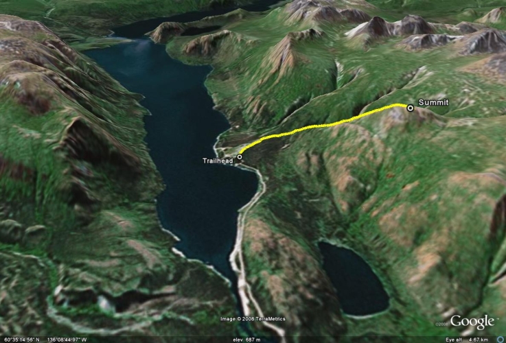
Total Distance: 8 km
Return Time: 4.5 hours
Elevation Gain: 844 m
Difficulty: Moderate
Region: Whitehorse
Traditional Territory: CAFN
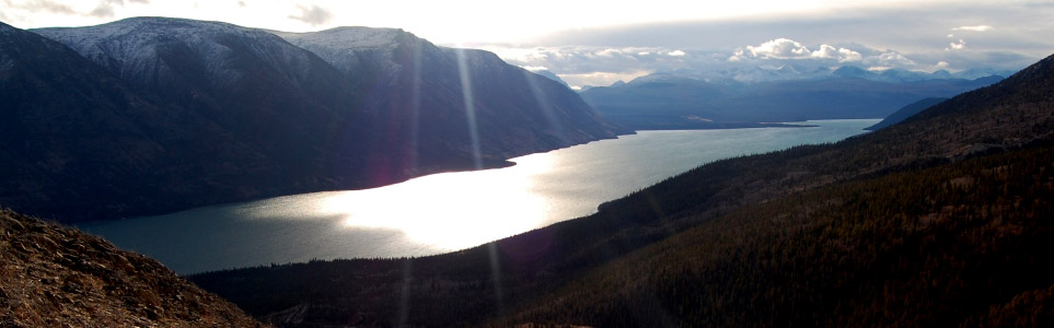
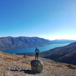
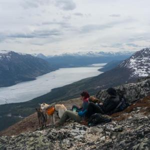
From the summit you are rewarded with a panoramic view of Kusawa Lake and the surrounding area. The ridge is fairly steep and can be quite windy, so be prepared. Dall's sheep frequent the ridge. If you see a group of sheep on a ridge, that is a good clue to adjust your route or turn around and avoid disturbing them altogether.
Drive about 65 km north of Whitehorse on the Alaska Highway until you reach signs indicating Kusawa Lake Campground on the left side of the road. Follow this dirt road past the Takhini River Campground to the Kusawa Lake Campground. Drive another couple hundred meters past the campground and park just before the bridge. The trailhead is on the right.
You can start the trail by following the path through the trees just before the bridge, or you can start by following the creek if it is not too high. Either way, you will eventually be following the creek on the north (right) side for about 1.6 km. Then you will leave the creek and follow a path through the trees towards the base of the ridge. The path can be braided and hard to follow at times, so just keep heading towards the base of the ridge. A worn trail is visible on the ridge.
At the base of the ridge you will start to climb steadily. The path up the ridge is more defined and easier to follow. The path will eventually disappear when you get to the rockier section. From here, pick a path up towards the summit. Soak in the beautiful view of the surrounding area and follow the same path back down.
Dall's sheep frequent the ridge. If you see a group of sheep on a ridge, that is a good clue to adjust your route or turn around and avoid disturbing them altogether.
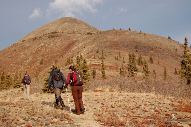
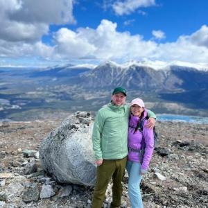
Hiking up the ridge with the summit in the background.
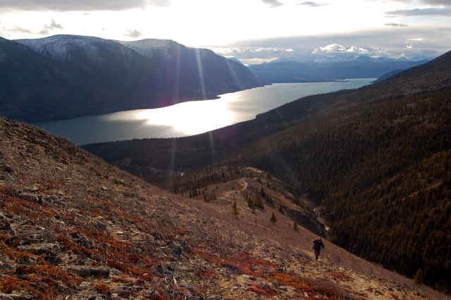
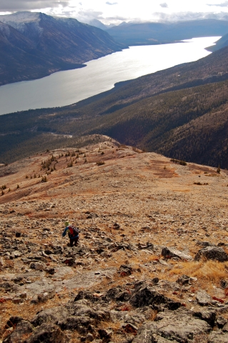
The careful ascent up the ridge with Kusawa Lake in the background.
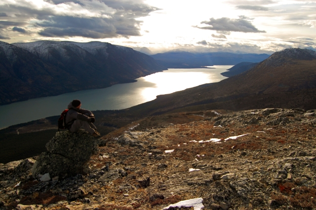
Soaking in the view of the long waters of Kusawa Lake.
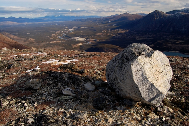
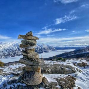
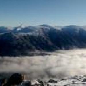
The view north from the summit.
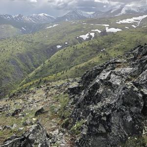
Descending the ridge. Never a moment without a beautiful view.
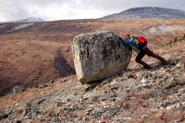
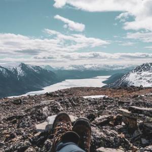
Having fun on the ridge, trying to create a new landscape.
Yukon Hiking May 10, 2025
Trip report passed on from a friend Friday, May 9th: Saw a group of sheep on the ridge, good reason to turn around. On the way down, ran into a black bear in the trees with 1 cub (treed). The mama stood her ground, and we calmly backed away. Make sure to make lots of noise out there and watch for bear sign.
Yukon Hiking April 24, 2025
Did the hike on Easter Sunday. No sheep were seen.
Snow patches remain in woods and the trail can be hard to follow at times. It was much easier to follow the creek all the way up from the bridge (and on your way back) as it is a solid ice/snow covered highway! If temperatures stay cool this will be a good option for the next couple weeks.

Ree April 16, 2025
Hiked today, didn't get all the way to the top as it was extremely windy but the trail is nicely dried out and snow-free above the tree line. Still some small snow patches in the woods but easy going, no snowshoes required.
CM September 18, 2023
Cold fall hike up Kusawa Ridge. The colours are at its peak brightness, lots of red and yellow. Last time I hiked this trail was in 2020. The trail has worn down quite a bit since then.
At the start of the hike we took random foot trails located deeper in the woods that eventually met with the trail on Ridge. Lots of worn in walking trails in the woods that branch off but most seem to lead to the ridge.
Coming back down from the hike we took a trail that stuck to the edge of the ridge and continues right up against/on the creek bed then cuts into the woods the last little bit to the road. We popped out right where we parked our vehicle and by a tree that is marked by a pinkish/orangish flagging tape around a tree. At the beginning of the hike if you take the trail marked by this flagging tape you will have a pretty defined trail the whole way up and won't be in the woods as much, it's not necessarily an easier route though, just a bit easier to know where you are going.
The section of the trail when you start the ascend up the ridge is extremely worn down. Very dusty and nothing for your feet to grip onto. These conditions combined with the steepness of the hike make for a slow and semi treacherous hike down. It almost took us the same amount of time to go down as it did going up.
Overall, nice hike, only saw one other group of people who turned around half way. Most of the berries have been eaten already and we did see one juvenile black bear eating berries and running around on the summit about 700 meters away from us. After the hike on the drive home we also saw a gigantic black bear (one of the biggest ive ever seen) on the road right by the takhini river campground. It saw us coming and ran into the woods so we stopped into the campsite to let the two campers know what we saw. They told us that they had spotted the same bear in the same spot 2 hours prior, so it seems that this big old bear is capitalizing on something in the area.. a good reminder to keep all food locked up while camping.
Kevin Rozon June 7, 2022
We summitted Kusawa Ridge on May 28. Trail was snow free and fairly easy to follow once past the initial forested area.
Wind was fairly tame on the summit or the day so it made for a beautiful spot to have lunch. Really enjoyed this one!
Aaron May 23, 2022
Summitted today. The trail was nice.
Jane July 28, 2021
Is this trail open now, thinking of hiking it on Saturday?
Zac May 24, 2021
Tried hiking this trail on May 24. Trail is currently closed (along with Kujo ridge) due to potential mud slides. Barricades and signs at the trailhead. Just an FYI.
Marianna March 22, 2021
Kusawa Ridge hike on Spring Equinox, March 20, 2021. My first time hiking it winter time. The conditions were excellent. Well packed trail, snowshoes and crampons are useful. Icy sections on the rocky part and steep hills warrant extra caution but it is doable right to the top.
Yolande July 27, 2020
Hiked this last Saturday, July 25th. Found a black Nikon camera lens cover on a game trail below the 'summit'. If it's yours, just leave a note here. Yup. Very windy up there.
Jen July 19, 2020
When starting the trail GO LEFT at the start. There are two trails that seem to mirror the description above but do not take the right trail as it leads far away from the creek that the hiking trail follows. We discovered that it leads very far off course and we ended up bushwhacking our way up to the plateau before the summit. This (wrong) trail was misleading as there was a well established trail to start and then some blaze tape that seemed to lead in the correct direction. Also, the ascent to the summit doesn't have a clear path. It's not a big deal and actually quite fun to chose your own adventure. Stunning views at the top.
Cam June 10, 2020
June 9th 2020 No snow, mud or washouts, clear all the way to the top. No bear spotted on the trail, although the day before we did see a grizzly and her cubs near by.
Beautiful views all the way to the top! Trail isn’t super developed, no official trail markers or signs so often times we accidentally went off trail. We followed an AllTrails map to get back on track.
There are a few orange ribbons attached to trees in the beginning. At the start of the hike there are two paths, take the trail on the left! The one with the orange ribbon in the tree.
First section is a lot of bush and fallen trees. The path parallels a beautiful creek for a bit. Eventually you start heading up the ridge where there is a defined trail. Once you start heading straight up the mountain you are climbing up large rocks so a trail isn’t very visible ( some stone markers in a few spots).
If you are ok with a little trail finding, the views are worth it!
Shailyn June 7, 2020
Hiked Kusawa Ridge yesterday. This was my second time up there and I enjoyed it just as much as before. We were lucky to only get some hail and rain at the top and not the lightning that was forecasted. Tons of sheep scat, but no other signs of wildlife. Took us just over 5 hours with tons of stops for photos, food, and to try to brush off our winter legs.
Liz B May 3, 2020
My husband and I hiked Kusawa Ridge on May 2nd. All said and done our hike was 8.5kms with an elevation gain of 950m. It took us just under 3 hours to get up (including a lunch and some photo breaks) and 1.5 hours to get down.
The trail is in great shape, snow free all the way up to the summit. We walked along the creek to get to the trail up the ridge. The first 400m of the creek was frozen which made for easy walking, the rest of it was open and required some rock hopping but overall still pretty easy to walk up.
We began the hike at 9:30 and were the second group on the trail. On our way down we passed 11 different groups of people. I would suggest starting early if you want to avoid the crowds.
Riley April 11, 2020
Lots of snow down below, but a packed trail! We had snowshoes but didnt need them much. The ridge was a mixture of dry spots and snow patches. Tricky footing with shallow melting snow over rocks, but doable if going slow! Saw 3 sheep. Would recommend either leaving the doggos home or leashing them. The road into the lake started to become quite muddy on the drive home.. cars beware :) beatiful hike!
Mabel June 4, 2019
Camped at Kusawa and hiked the ridge trail on May 25th. Beautiful day! We had a couple false starts since most of the comments say to follow the creek and not the trail, however the creek still had quite a bit of ice and we had a baby with us so we didn't really want to risk it. We ended up running into another group with a GPS which was quite helpful! We started on the main trail for about 10 mins and then cut over to the left and found the trail that follows the creek. Didn't see any flagging tape that others have commented about. Very easy to follow once on the second trail.
Pippa Lawson September 16, 2018
Awesome fall colours on today's hike up Kusawa Ridge. We went to the second (snowy) summit. No water for dogs up high but they were able to hydrate with snow. We made the mistake of taking the right fork at the beginning and doing a long (app 1 hr) traverse detour away from and then back to the main trail which follows the creek. This wasn't bad but did involve bushwhacking and some rock scrambling. To avoid the detour, stay left at the start!
Sadie May 27, 2018
Went up the trail on May 27th, but mistakenly followed the marked trail rather than reading the comments and following the creek up. Ended up just below the treeline and got lost. Decided to descend as the weather was looking grey from up there. Took awhile to find the trail back down.
Apart from getting lost about two thirds up, the views were beautiful.
Oh and the marked trail had old bear scat on it..it was dry and definitely old, but bring bear spray/bear bangers as with any summer hiking.
Cata May 17, 2018
Hiked it on May 8th. No snow on the trail up. The first part of the trail is a bit confusing, there is a few different paths but once you get out of treeline is pretty obvious where to go.
Jenn April 16, 2018
Hiked on April 7 and there is a mix of snow and rock. It is hike-able without snowshoes. I dropped a black sunglasses case on the trail so if anyone finds it, please let me know!
A & B October 1, 2017
A rocky hike, but a beautiful hike. Definitely agree with the previous suggestions regarding the creek. Following it up was incredibly easy, though spotting the tiny flag that signalled the trail to the alpine was not. Keep your eyes peeled once you reach the big rock wall on the left hand side (past the 2 sandbanks also on left hand side), and across the creek and up above on the right there's a tiny orange ribbon wrapped around a tree.
2.5 hours up to the boulder below the summit, just over 1.5 hours back down. Loved it!
Derek Peters August 19, 2017
Don't follow the well worn trail that someone flagged... it doesn't get you to the ridge. Follow the creek.
Jason Wright June 18, 2017
Hiked up on 18 June 2017. Beautiful day with very little wind and lots of sun. Lots of sheep scat, but no sightings of the producers. Passed a group of ~15 NOLS hikers on our way down on their way in on a 21 day trek. Bugs were annoying at times in the alpine due to lack of wind, but they were more the swarming type rather than the biting kind. Still a bit of snow on the backside of the peak (the dog especially enjoyed the snow after the climb up).
Sophie C. June 14, 2017
We did it on a rainy, windy day and it was still a great hike. We saw a white-tail ptarmigan and two sheep. I lost my camera on the way up, if someone finds it, could you please bring it at the village Bakery in Haines Junction?
Jo October 29, 2016
Hiked Kusawa ridge on Sat Oct 29th. Started out under an obscured sky and ended up in an inversion with bluebird skies for the rest of the day. From the summit of Kusawa ridge, we continued NW and crossed a gully at GR 341186 1380m before heading fir the E ridge of another summit at GR 310183 1950m. We descended from that summit in a SE direction and crossed the top of a gully at GR 331165 1570m before following the ridge S of that gully (some bushwhacking) to intersect with the creek we followed first thing in the a.m at GR 361164 840m. Great circuit and great fall day spent up high.
Darren Yuill July 13, 2016
Hiked on June 27 We went to trail head just before the bridge and started to follow what seemed to be a well worn path. After 20 mins we realized we were just walking parallel to the lake and not really climbing up. Re trace our steps to trail head and followed the creek.The trail was crossed with trees and branches. Not a real clear path . Once we got higher the trail became more clearer. This was a really spectacular view and worth the confusion at the start. Had a really clear day.
Ellie & Blake April 25, 2016
Hiked this train yesterday. It was a beautiful, warm, sunny day with little wind.
Along the Alaska highway going north, you'll see a sign for Kusawa Campground, indicating you to turn on the left hand side. Drive down the dirt road for about 25km until you come to a small bridge. Park on either side of this bridge.
Start hiking along the side of the creek. There are rocks you can walk on, never getting your feet wet. I recommend going up the creek rather than through the bush. Follow this creek until you come to a rock wall and the orange flag on the right hand side about 2km in. You'll be able to see the trail up the ridge from the creek and you can climb up the creek side to the trail.
Once on the trail, it is easy to follow but pretty steep! Follow this trail all the way to the alpine, where the path will come to an end.
You'll be able to see the summit, and you can easily make you own way up over the rocks.
There were MOSQUITOES the closer we got to the summit, so we felt like we couldn't rest or sit still for long, but we saw some mountain goats along the slope.
jukia g September 23, 2015
One ofthe best hikes. Spectacular views. Did it at the beginning of September
Drew Osborne September 11, 2015
Hiked the ridge on Aug. 2nd. A couple easy pointers so you don't get lost on this trail.
1) park your vehicle on either side of the small bridge between the campsite and the campsite extension.
2) hike up the creek bed. I had to cross the creek a few times because the banks got steep but this was easy because there were lots of rocks. My feet never got wet.
3) after about 2km look for pink (maybe orange?) flagging tape on creek right. Alternatively, look for an obvious steep rock wall on creek left - when you are perpendicular with the wall (or you see the flagging tape), bushwhack about 30m to your right (into the forest) until you cross the obvious trail.
4) once you are on the trail it will rise above the tree line and eventually stop at the base of a big boulder about 1km short of the summit. At this point you are in the alpine so just pick a route and head for the summit.
Great hike!
Judy July 17, 2015
I did this hike yesterday or I should actually say I attempted this hike yesterday.
I read the comments on this hike and I was planning to follow the creek but because you need to bushwhack at the beginning I thought it wasn't right. I should have.
I ended up following the marked trail until the markers disappeared and we ended up in thick brush. There are game trails everywhere that are quite deceiving. We made the call to just climb straight up. An hour later we threw in the towel and headed straight back down.
I will do this again just because I felt defeated and I don't like losing. The next time I will follow the creek. :)
Amy July 2, 2015
Beautiful spot - but I recommend following the creek, not the trail!
The beginning of the trail was clear and up until about 1/2 way up we could follow orange markers and traces of trail, which seemed to be taking us along the ridge rather than up to it. All traces petered out and we had to bushwack - and got in a few dense places.
When I got back to Whitehorse I talked to 4 other people who had had similar experiences, so thought I should mention it here. Following the creek is much clearer and easier.
Pete, Susan ,Kyle and Courtenay July 2014 July 29, 2014
Our family had a great morning hike and noon picnic atop the summit In mid July with a clear Yukon sky full of sunshine, wild flowers, junipers and other fauna all in bloom. The absence of any breeze enabled to hear the echo of an eagle and two falcons nearby. The creek water was icy cold yet sweet in taste ,....all in all a great day to return to one of our most favourite family spots. First trip for Kyle and Courtenay since their last in 2000....later that day a remembrance for the grandparents at the dunes was enjoyed which then had us back at the landing for a riverside dinner BBQ.
Travis May 21, 2014
Great views close to Whitehorse. We did this hike May 18th in a group of 6. I guess there was some flooding in the area last year, so the walk along the creek does involve a bit of bushwacking, but it's mostly easy navigation through sand and rock. Just follow the creek and you can't go wrong. Once into the alpine the trail is very obvious.
The ridge was pretty windy but plenty of lunch spots on the lee side out of the wind.
Took us about 5.5 hrs total with plenty of quick breaks and a half hour stop at the summit. Highly recommended.
Vi August 7, 2013
The recent heavy rain has washed out part of the trail following the creek, some bushwaking is now mandatory. To find the trail climbing the ridge, I recommend looking for it from where the rocky canyon is (before that it is mostly rocks and sand). Highly recommended, the view on Kusawa and the Takhini river is worse the climb.
