Total Distance: 55 km
Return Time: 4-5 days
Elevation Gain: 2123 m
Difficulty: Moderate
Region: Kluane
Traditional Territory: KFN, WRFN
This route connects Bock's Lake to Congdon Creek via the Duke River. It requires some route finding, but it is a fantastic multi-day hike through some amazing terrain in Kluane National Park.
Drive 100 km north of Haines Junction on the Alaska Highway. About 14 km north of the Congdon Creek Campground you will see a highway sign for Bock's Creek, as well as a wide creek bed. You can pull off the highway onto a road, just after the creek on the north side. This is an active mining road, so leave room for vehicles to get past.
Note: While Bock's Lake itself is not in Kluane National Park, this connector hike does go into the park and therefore mandatory registration with Parks Canada is required.
The first day follows the route to Bock's Lake. You can spend an extra day at Bock's Lake if you want to explore the area.
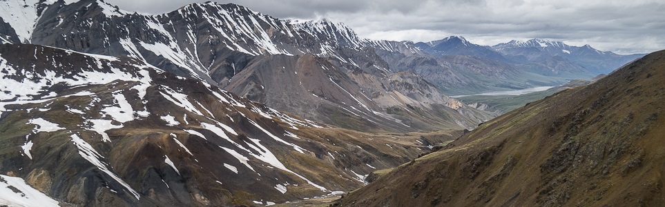
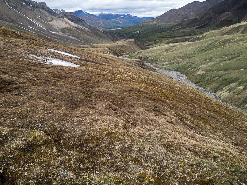
From Bock's Lake, follow the route to the pass between Bock's Lake and the Duke River. The descent from the pass is not bad, as the loose talus actually helps you plunge step down. At the bottom of the pass, you will follow the valley out to the Duke River. The valley is fantastic walking on grassy flats that have been mowed by the resident sheep. There is an interesting array of rocks strewn about further down the valley.
When you reach the bush line, you can continue walking through the small bushes, as they are pretty easy to walk through. Eventually you will get into some higher bushes, at which point you can descend to your right (north) down to the creek below.
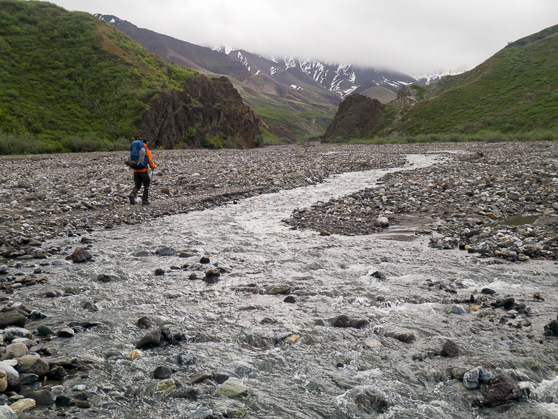
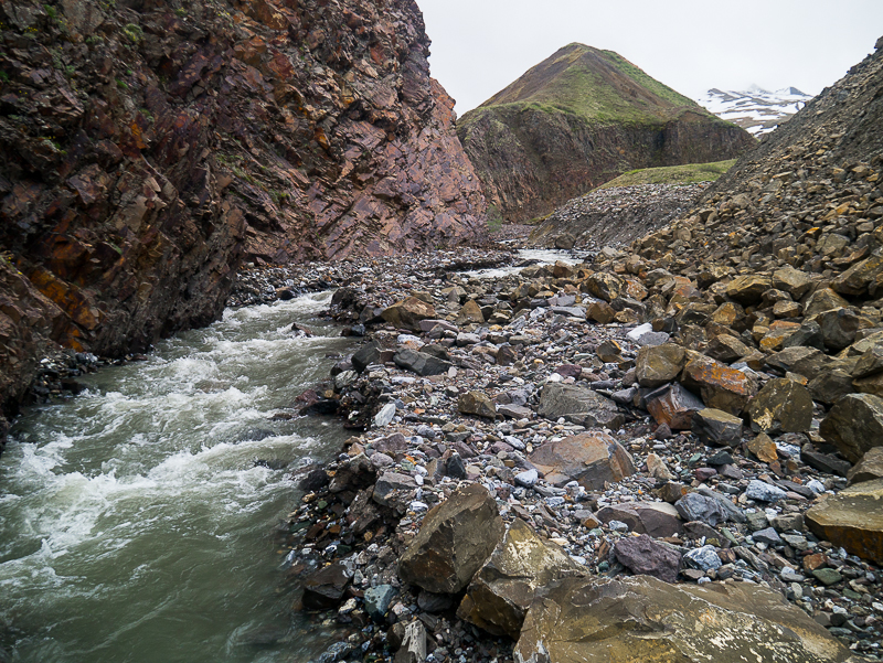
If water levels are low in the creek, you should be able to avoid crossing it multiple times. There are a couple of canyon sections which will require a little navigating, either on the sides of the creek bed, or above on the adjacent hillside.
Once you are through the canyons, the creek bed becomes very wide and you can follow it down to tree line. As soon as you reach tree line, you will be at the Duke River.
The Duke River is a very wide, braided river valley. You can follow it southeast on the river bed. You may be forced to cross it (or one of its many braids) if it meanders too close to the bank, depending on water levels.
After about 6.5 km, you will reach Dickson Creek, entering the Duke River from the east. If you want to camp here you can cross Dickson Creek and camp on the flat, open ground that is betwen Dickson Creek and the Duke River.
From here, you will be following Dickson Creek upstream all the way up the valley. Creek crossing shoes come in handy here, and you might want to leave them on, as you may have to cross Dickson Creek up to a dozen times.
Further upstream, three tributaries of the creek will come to form the main Dickson Creek, with beautiful rocky cliffs and hidden waterfalls. The easiest thing to do at this point is to climb up the hillside on your right (south). You may be forced to walk along side one of the creeks briefly before crossing it and getting up on the hillside again. When you are up on the hillside, it widens out but is a little convoluted with lakes and creeks. Aim to get close to the high shoulder to your left above Dickson Creek.
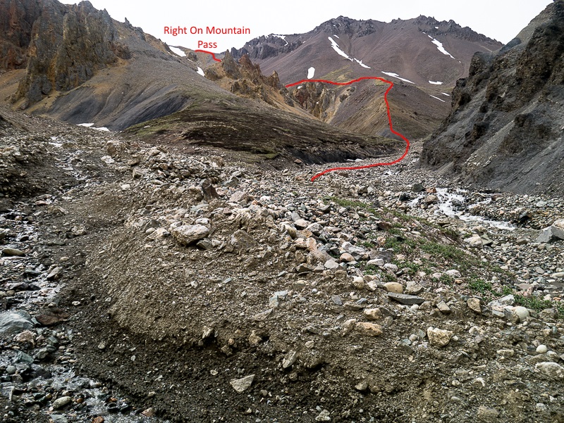
In the mountains up ahead and to the left is where the next pass is, the Right On Mountain pass. Continue climbing up the hillside. Eventually you can start sidehilling and descending down into the creek valley below. When you get to the creek bed and nearly reach the end, follow the left fork a bit further. You will reach yet another creek valley which runs down from the pass (on your left now). To climb to the pass, use the rightmost hillside.
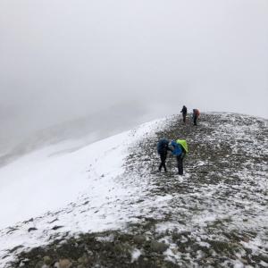
Near the top of the pass you will have to scramble over a rocky section briefly. When you reach the top of Right On Mountain pass it will flatten out and become a small plateau. Walk across the plateau and look down the other side towards Congdon Creek.
The descent from Right On Mountain pass can look intimidating. It looks like a narrow, steep, gully and very high up. But don't worry, there is a gentle route down. Make your way down the gully until you can get back up on the hillside on your left (north). Follow the hillside downwards, staying just left of the gnarly rock formations.
At the end of the hillside, there is a narrow ramp that angles gently down to the creek below. Follow the ramp down. At the end of the ramp, follow the creek down until you reach the confluence with Congdon Creek.
At the confluence of Congdon Creek, you can look for a flat section to camp on, although there is not much to choose from. From here, you could hike out Bullion Plateau or follow Congdon Creek back to the highway.

Descending the pass between Bock's Lake and the Duke River.

Easy walking on the plateau in the valley below the pass with rocks scattered about.
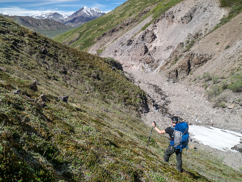
Leaving the plateau to avoid the bushes and to hike along the creek bed.

There are a few canyon sections on the creek.
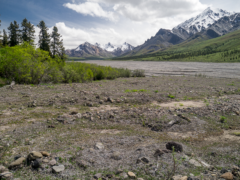
Arriving at the Duke River.
Hiking up Dickson Creek. You may have to cross the creek multiple times.
When Dickson Creek splits, you will be forced to walk up on the hillside or carefully beside the creek.
Looking back down Dickson Creek from up high on the hillside.
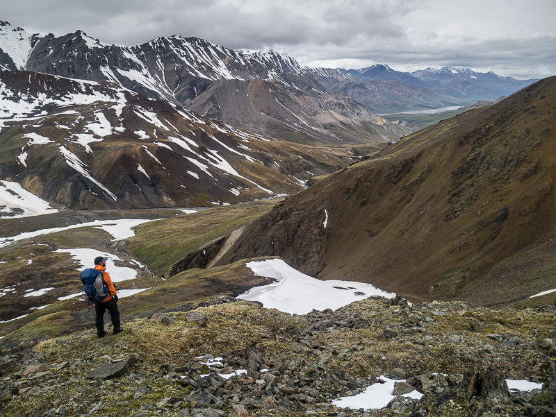
Starting to hike up to the Right On Mountain pass.
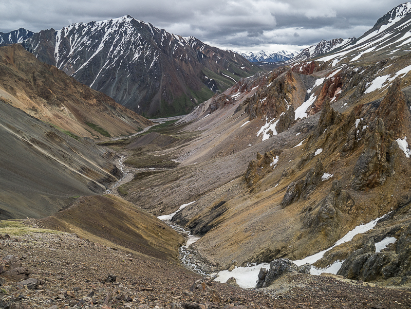
Looking down the other side of the Right On Mountain pass towards Congdon Creek. The bottom left of the photo is the ramp you follow to descend.
The route down from Right On Mountain pass to Congdon Creek.
Chris June 10, 2025
Hi All; wondering about getting back to Bock's creek from Congdon Creek after the hike. We will only have one car in the area. How is the hitch hiking between trailheads or is there a commercial shuttle somewhere close? Thanks
Heidi August 17, 2020
We did this hike Aug 4-7th. It was pretty epic! We had great weather (mostly) and water levels were low therefore our creek crossings were only in the double digits (I am sure with high water it's a lot!). We put in a couple of pretty long days to be done in 4 days. Navigation skills are definitely required along with a sense of adventure if you happen to end up on the wrong slope, hill, ridge, etc :) There are also some pretty steep slopes, though they are shale so they "help" you down. Based on the ratings on this website I would definitely rate this hike as difficult rather than moderate - in comparison to Grizzly Lake specifically. I find Grizzly moderate based on the fact that there is a well used trail in as well as nothing too steep. That being said it was an amazing hike I highly recommend. If you'd like more info you can go to the Facebook Group Happy Hikers Yukon - there are posts there from people who have done it as well and all are happy to answer questions/give info.
Happy Hiking!
Jean-Paul Molgat July 10, 2020
We did the hike over 6 days from July 4-9. A great hike through an amazing wilderness landscape.
Be prepared for several creek crossings (we did about 30) and for all kinds of weather. Right on Mountain Pass was a white-out on July 8 when we went through and snow fell to about 1500 m that night.
When you get to the pass above Bock’s Lake, keep walking along the ridge to your left until you find a fantastic shale slope, which is a fun (and safe) plunge-step descent toward the Duke River.
Note that the route described (the red lines on the two maps above) is actually 29 km (from Bock’s Lake to Congdon Creek junction), not 55 km. The entire route from Bock’s Creek trailhead at highway and back to highway along Congdon Creek is 55 km.
Maodé Craig July 10, 2017
wanted : Right Salomon Speedcross hicking shoe.
Hey ! I lost a shoe between Dickson Creek and Bock's lake. I was walking on a sheep trail (grey steep rocky slopes) coming back from Bocks lake to the creek.
Help me I am lost. My she was everything for me.
Cinderella is waiting for you !
email me maude.craig.duchesne@gmail.com
Arno Springer August 28, 2015
We did a nice variation of this route where you start and finish at Nines Creek, so no shuttle involved. The real bonus is that there is a mining road up Nines Creek that takes you about 4.5 km up to the base of the mountains. Turn left off the highway at a road to a gravel pit 1.4 km after the 1674 mile marker (UTM 07V 0624892: 6786967). Follow this road around the gravel pit to its west side where you will find another road heading west to the mountains. If you have reasonable ground clearance you can follow the road all the way to the end (about 4.5 km). Regular car will get you in about 4 km. Be aware that there are limited places to turn around if you change your mind as you get to the end of the road.
The hike follows Nines Creek up to where you can easily cross over to Bock's Creek and follow the route description in this guide up to Bock's Lake and further on to Right on Mtn. From there you do a high traverse back into the south arm of Nines Creek which takes you back to your car.
