
Total Distance: 21 km
Return Time: 6.5 hours
Elevation Gain: 424 m
Difficulty: Easy
Region: Tombstone Territorial Park
Traditional Territory: THFN
This route follows a horse trail along Foxy Creek and then up to the alpine plateau of Auston Pass in the Blackstone Range of Tombstone Territorial Park. This would be a long day hike to and from the pass, and it is better suited as an overnight/multi-day trip so that you can explore the area around the pass (see extended hiking options below). The views are stunning along the entire route. This pass is also used to access the Blackstone River Valley and Syenite Lakes to the south.
Consider avoiding this area during the hunting season, as it is popular with outfitters and local hunters, with gut piles resulting in more bear activity.
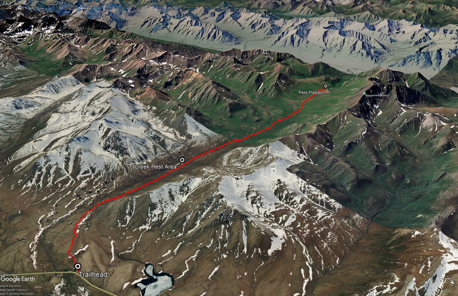
Drive north on the Dempster Highway to around KM 91 on the highway. There is a small pullout on the left, about 150 m after a horse stable (on the right). The trailhead starts at the south end of the parking area, where a light trail can be found going through a small gravel pit. This is the same trailhead as for Rake Mountain.
NOTES ABOUT BAKCOUNTRY TRAVEL OFF-TRAIL IN TOMBSTONE TERRITORIAL PARK:
Once at Auston Pass, there are no trails. It is advised that you are experienced in route finding, backcountry travel, and are well prepared and self-reliant. Choose durable ground and spread out to prevent creation of new trails on the fragile tundra vegetation and permafrost. Avoid wet or muddy areas where possible and stick to higher group and follow ridgelines.
Registration is mandatory for camping within the park. Please visit the Tombstone Interpretive Centre to acquire the correct park permits, and receive up-to date information on trail conditions, closures and wildlife activity.
Park approved bear-resistant canisters are mandatory (only hard shell, not soft bags) for all backcountry camping. Dogs must be on a leash at all times and fires are not permitted.
CAUTION: This area is used by hunters during the hunting season, which starts August 1st. Parks Staff and Conservation Officer Staff often find gut piles left from hunters which attract bears. Consider avoiding this area during this time, and/or check with Parks Staff ahead of your trip.
-------------------------
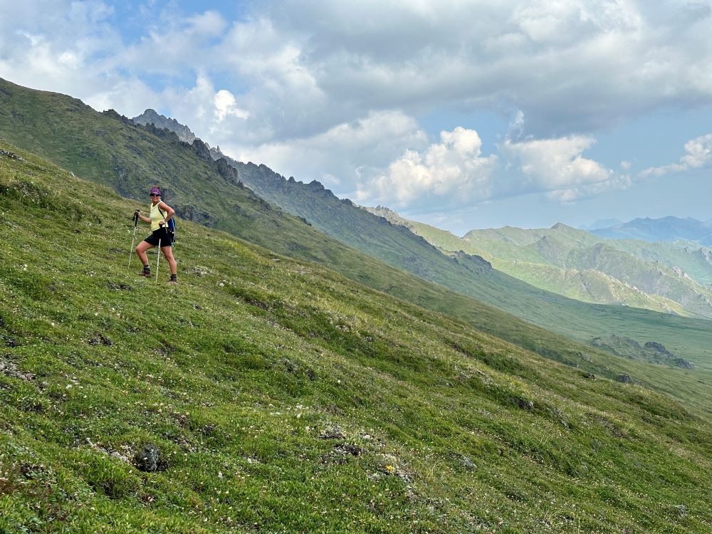
Follow the trail leading out on the left from the parking area (it will follow the right of the small gravel pit). Pick up a well-worn horse trail through the shrubs. This trail will take you across the tussock plateau below Rake Mountain and then up the valley along Foxy Creek. There can be some wet and muddy sections on the trail to navigate through, and of course watch out for fresh horse poop, as this area is used by a guide outfitter.
As you hike, you will pass the shrubby ridges of Rake Mountain, Mount Auston and Blackstone Mountain on the north side of the valley. While there is a trail the entire way, you are still pushing your way through the willow and buckbrush as you go (note: shorts may not be the best choice for clothing as your legs will take a beating).
There's an opportunity to rest by Foxy Creek around 4 km from the trailhead, when the trail is adjacent to the creek. The elevation gain is quite gradual until about 7.4 km. After that there is a short climb about 150 m up to reach the plateau. The plateau then gradually climbs to reach the pass about 10.5 km from the trailhead.
From the pass, there is good camping, you just have to find somewhere that is flat, and not all hummocks (grass mounds). There is water on the north side where Arrow Creek comes down from between Waterfall Mountain and Blacktone Mountain. Note, the horse trail continues down to the Blackstone River Valley. People access this area for packrafting out the Blackstone River or extended trips up the Blackstone Valley to Syenite Lakes and Tombstone Pass.
It is well worth camping at the pass to explore the alpine areas in the surrounds. See one of the extended hiking options in the area below.
EXTENDED HIKING OPTIONS
UNNAMED PEAK ABOVE FOXY CREEK
This unnamed peak rises from the pass to the south and has great views in all directions. You'll need to traverse the plateau to the south towards the base of the mountain. Crossing the plateau requires walking across the hummocky landscape for about 1 km. Take the ridge on your right (south) up to the peak, picking the easiest route. It's about a 660 m ascent from the pass to reach this unnamed peak (altitude: 1,936 m). After checking out the peak you can hike down to the southeast and hike along the ridge above Foxy Creek. The views down and up the Foxy Creek Valley are stunning. Either return the way you came or keep connecting the ridges and peaks for your own route and a longer hike.
UNNAMED LAKE CRY CREEK
This unnamed lake is nestled among some beautiful rocky ridges to the southwest of Auston Pass. This lake drains into a tributary of Cry Creek and then down into the Blackstone. To access the lake from the pass, traverse the hummocky plateau to the southwest. Then drop down to Cry Creek, scoping out a good crossing. There's a little bushwacking to get down to the creek, but most of it can be avoided by picking a careful route. From the creek you can either ascend the steep ridge directly on the other side of the creek, and then go up and over to get down to the lake, or you can side hill around the west of this steep ridge and up the valley to the lake.
Another good option from Cry Creek is to head up the main valley. It looked like easy hiking and there is a cool waterfall near the head of the valley.
WATERFALL & BLACKSTONE MOUNTAIN
These peaks on the north side of Auston Pass are accessible via a mellow ridge directly from the pass. It's about 400 m ascent to reach the ridge that connects these two mountains. The views from the ridge are stunning in all directions and it's a great little outing in itself. You can see down to the Blackstone River valley directly west, and over the other side to the north. To summit either Waterfall Mountain to the west or Blackstone Mountain to the east along the ridge would require some steep hiking on loose rocks and significant elevation gain.

Following the horse trail along Foxy Creek.

Resting by Foxy Creek about 4km from the trailhead.

Looking up the Foxy Creek Valley as you climb up to Auston Pass.

Climbing up to the pass as you leave the Foxy Creek Valley.

Auston Pass in all of it's alpine flower glory.

From the pass looking down into the Blackstone Valley towards the Seela Range to the west. The horse trail continues down into that valley from the pass.

The hummocky terrain of Auston Pass.

Hiking up to the unnamed peak to the southeast of the pass.

The view looking back down the Foxy Creek Valley from the summit of the unnamed peak at 1936 m altitude.

Hiking down the ridge to the southeast from the unnamed peak to get a better view of the Foxy Creek Valley. There are so many ridges you could connect in this area.

The view down into the Foxy Creek Valley from the ridge to the southeast of the unnamed peak.

Hiking to the Unnamed Lake, by climbing the ridge on the other side of Cry Creek. Photo shows the upper Cry Creek Valley.

Reaching the top of the ridge above the Unnamed Lake.

The view of the unnamed lake from the ridge above.

The lake was shallow along the shore, but perfect for a refreshing dip.
Hiking the ridge to the north of Auston Pass between Waterfall and Blackstone mountains.

The view from the ridge towards north of the Patrol Range and Blackstone River. Note smokey conditions in picture.
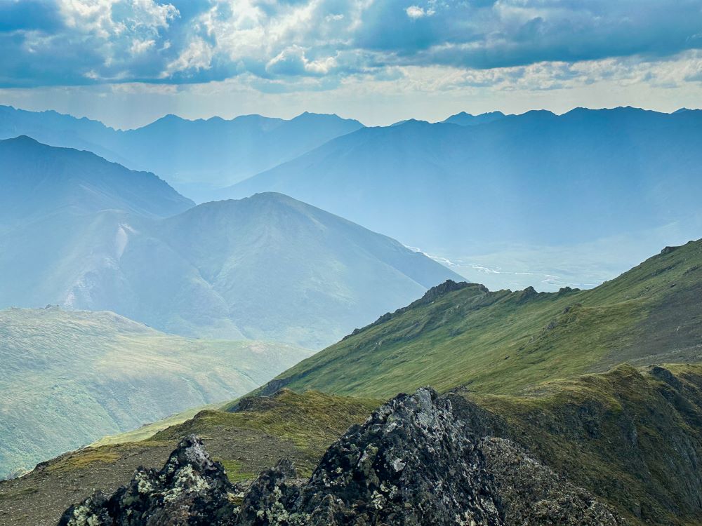
The view from the ridge near Waterfall Mountain, looking towards the Cloudy Range and the upper Blackstone River.

Waterfall Mountain from the ridge.
Cata January 29, 2025
I recommend doing the whole loop, Auston pass to Syanite likes, down to the tombstone river, talus, out. It’s a stunning hike! 💯
Tammy B. January 27, 2025
This is one of the coolest valleys to hike down in Tombstone! Awesome views of the cloudy range at the end of the valley and a lot of wildlife (past few years there has been a grizz frequenting the valley). A heads up that during the fall this area is heavily used for hunting both by the outfitters and by locals. If you hike this during the fall there will likely be several people back there and keep an eye out for possible gut piles. Beautiful area and worth spending several days in there if you are hiking in the summer!
