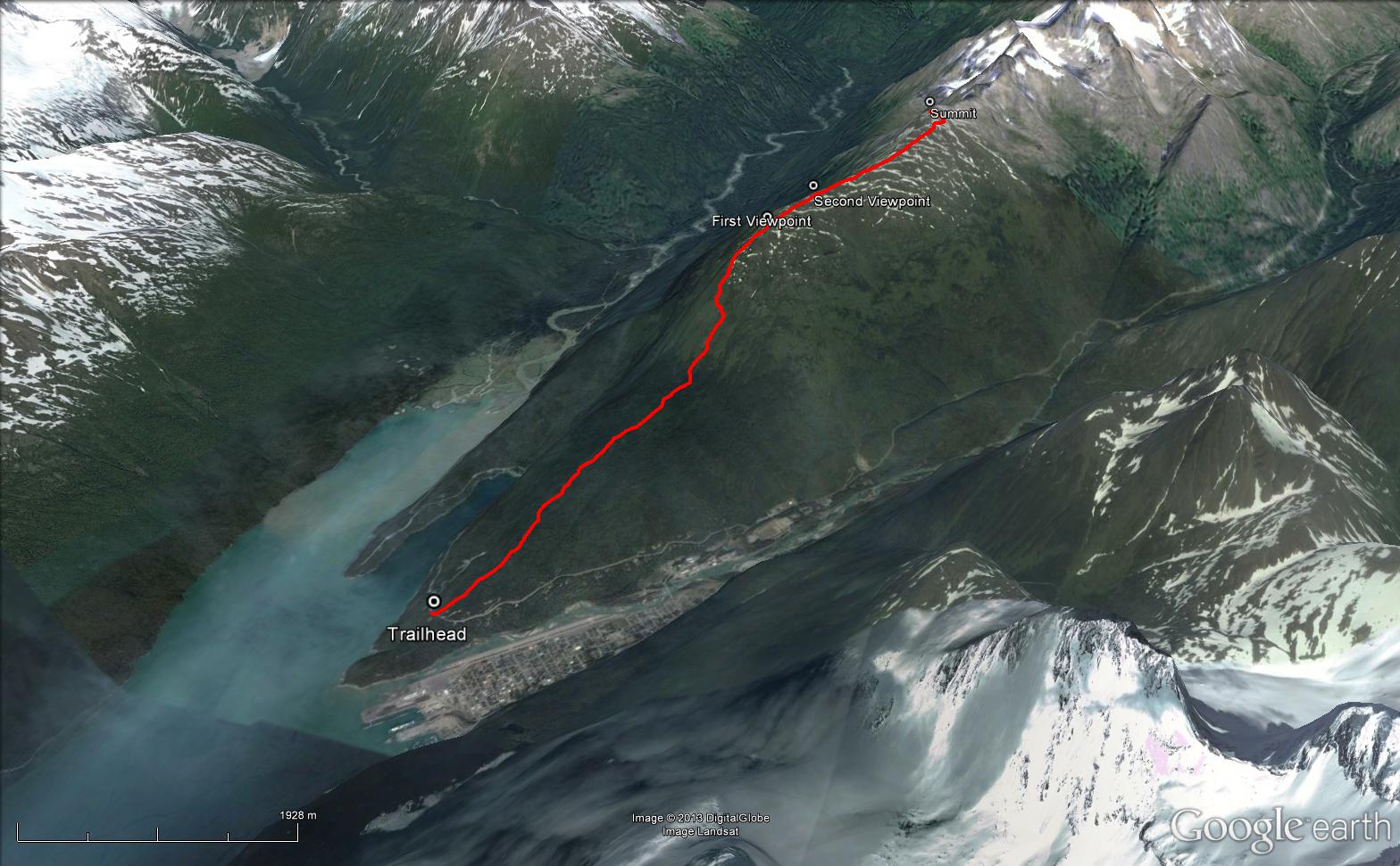
Total Distance: 11 km
Return Time: 5-7 hours
Elevation Gain: 1175 m
Difficulty: Difficult
Region: Skagway
Traditional Territory: STC
The steep trail up to AB Mountain gives you the best of both worlds - ocean and mountain views. The jaw dropping, 360 degree views of Taiya Inlet, Dyea, the town of Skagway, and the numerous peaks and glaciers won't disappoint you. You can choose to go as far as you like, either to the first viewpoint (10.6 km return), the second (12.2 km return) or even to the summit (17.4 km return) depending on the amount of time and energy you have.
Drive south on the South Klondike Highway from Whitehorse to Skagway, Alaska. Approximately 7 km after crossing through the US Customs (bring your passports!), turn off the highway to the right onto the Dyea Road. Drive for another 3 km until you reach a small pullout on the left and a trail sign and trail on the right. This is the parking area and trailhead for the AB Mountain hike (also known as the Skyline Trail).
AB stands for Arctic Brotherhood, a fraternal organization formed during the gold rush in 1899. The trail is wide and well maintained for the first part of the route, passing through beautiful birch and hemlock forests. The elevation gain is very gradual for the first 3.5 km and then the trail starts to really climb, becoming much steeper and more overgrown. You will need to use your hands in some spots to climb up, and there is one part with a rope to help you along a section of slippery rock (test your weight on the rope before climbing).
You will reach the first viewpoint after 5.3 km once the trail gets above treeline (1,175 m elevation gain). After this the trail levels out and the elevation gain is much more gradual. Note the trail can become less defined in some areas once in the alpine, so do your best to stick to the main trail wherever you can.
From the first viewpoint you can continue another 800 m to a second viewpoint a little higher up. The views from the second viewpoint are pretty spectacular with Taiya Inlet, Dyea, Skagway and the many surrounding peaks and glaciers. The true summit is 2.6 km further and another 300 m up along the ridge. There are a few ups and downs along the ridge so it can be easier to traverse along the east side (right side) of the ridge and then up to the summit. The views are pretty similar from any of the three options along the ridge, aside from getting a closer look at the rocky spires of Mount Clifford from the main summit.
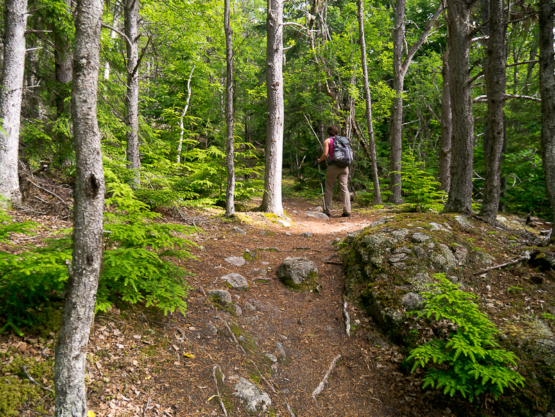
The first 3.5 km of the route is along a wide, well maintained trail through the forest with gradual elevation gain.
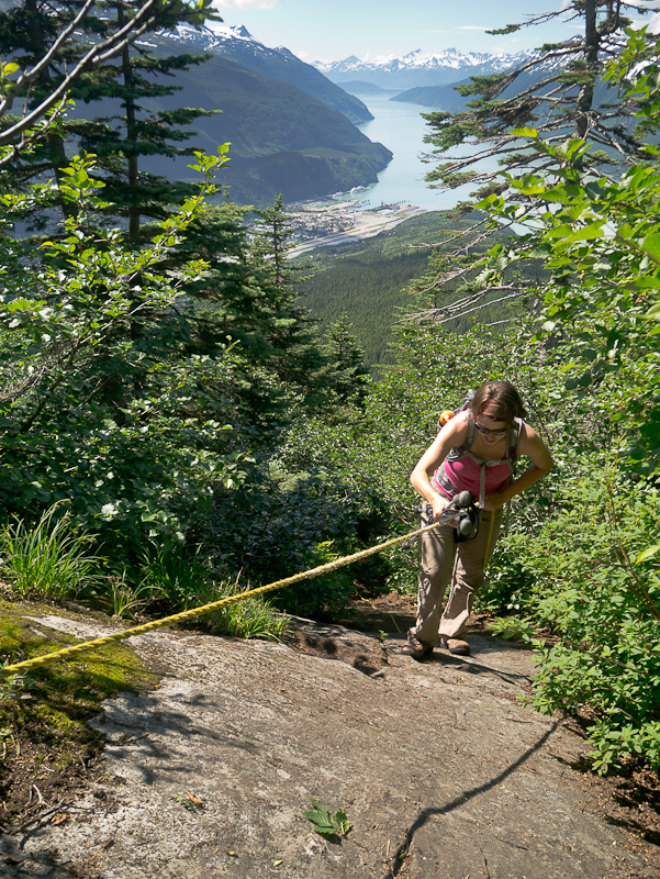
After 3.5 km the trail becomes much steeper and overgrown, and there is one section with a rope to help you up a steep, slippery spot.
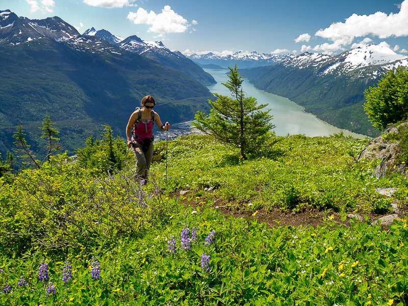
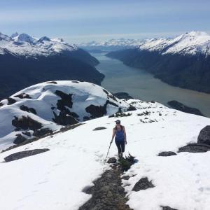
Once above the treeline the views open up and walking becomes easier.

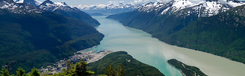
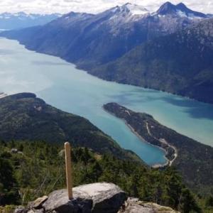
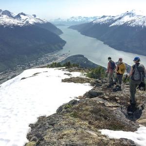
The view from the first viewpoint, looking down Taiya Inlet.
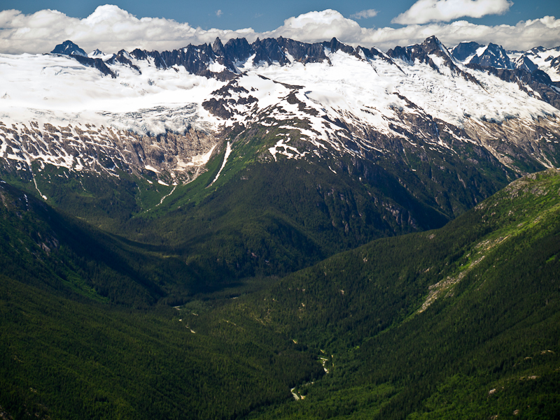
Enjoy the glacier views all around you as you continue along the ridge.
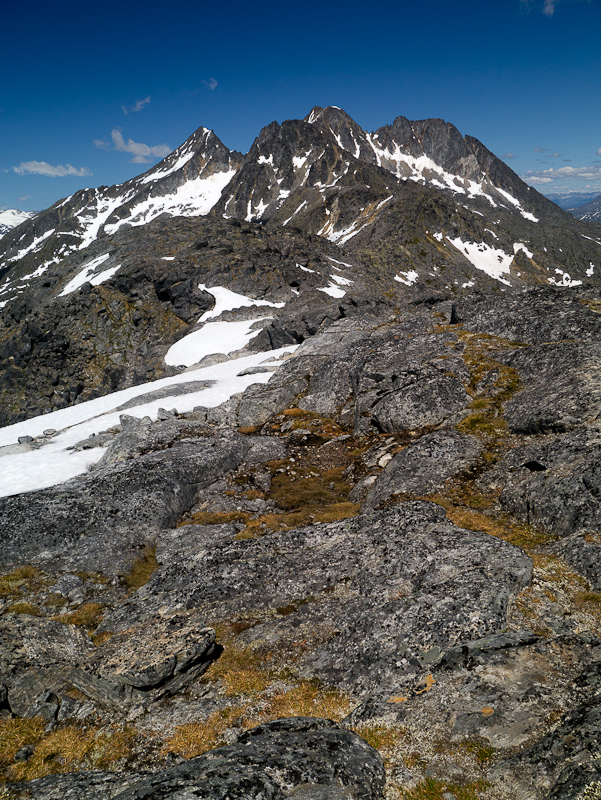
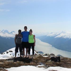
A view of Mount Clifford can be seen from the summit.
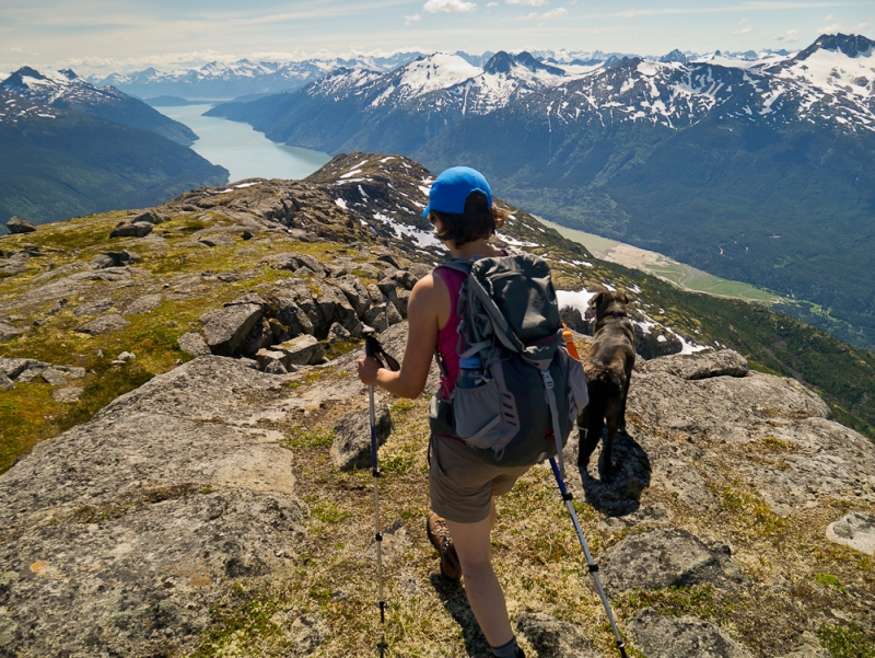
Enjoying more of the views on the way down.
Justin Vorp August 2, 2020
I hiked this mountain last summer. I made it to the "End of Trail Maintenance" sign, and had to turn back due to time constraints. Anyone know if this is summit, or if it was further up?
Paul Boileau July 6, 2020
Would like a hiking partner for a 10-day 80km hike north of the Itsi range east of the North Canol Road past Portrait Lake. Please call me at (604) 997-4183 if interested. There are no trails, this is true backcountry.
Kyle August 20, 2019
Steep hike like all the hikes in skagway but also great fun. Did the 17.4k in 3:50hours.
Always nice to get to the summit and have the opportunity to explore more with the 360 panorama views. As always the trail is very well made with some ropes here and there for steep rocky sections.
M&D April 18, 2019
Climbed AB to the first viewpoint Sunday April 14. Some small snow patches and muddy spots, but mostly clear. Only needed hiking boots and extra granola bars. Some friends biked the lower section and it was clear and dry. Beautiful views out over Skagway & Dyea.
Craig June 4, 2018
Did This Hike June 4, 2018. Unfortunately clouds rolled in when we reached the first viewpoint so the view was obscured. It was a very challenging hike, Took us about 4 hours to do the 10 km. The Trail was easy to follow though and was well marked.
Yukon Hiking April 10, 2018
Hi owtg,
A lot of the 'trails' on the website, are actually routes, so are not marked or maintained. We can recommend some that are actual trails and easy to follow. Feel free to send us an email through our Contact Us page and let us know what parts of the Yukon you will be visiting
owtg April 8, 2018
Hi, I HAVE not been to the Yukon yet, but going end of June - wondering if the trails listed on this website are well marked? We are avid hikers, but this time we will have our infant daughter with us! She'll be 5 months - we are sticking to some shorter, easier routes of course.
Thank you -
Brittni September 4, 2017
Hard but worth it! We did the climb in 2 hours and took 2 more hours to go back down. It was pretty muddy in some spots which was fine going up but going down it was quiet slippery. I recommend having shoes with good traction. I wore regular runners and had no issues other than the mud coming down. I was surprised to run into about 6 other groups along the way. I brought my two year old German Shepherd and she did great as well! Highly recommended.
Heather Dundas May 31, 2017
We hiked for about 2.5 hours this last Saturday (May 27, 2017). Didn't get up above tree line, but still really loved the hike. What was very surprising however was that there were three "groups" of bikes - one pair coming down and then two singles going up. It was startling to image them biking any direction.
David March 30, 2017
Just a quick response to K. Sparky Russell below. Hard to say what the bugs might be like - it depends on when in May you're here, and what the spring is like. Having said that, I can't ever remember bugs really being an issue for us planning any hiking or paddling, so I wouldn't worry about them.
Although this site attracts lots of views, it isn't a very active site as far as discussions. If you're on Facebook try posting on the Paddling in Yukon page - lots of activity, and most people who paddle also hike/climb so you might have better luck with responses.
K Sparky Russell March 23, 2017
Hi Folks:
I am coming to Whitehorse in May 2017 and have questions:
. what are the insects like?
. who to contact for climbing, hiking, paddling?
Thanks,
K. Sparky Russell,
ACC Toronto Section Rep
Jo October 2, 2016
Hiked A.B Mt on Sat Oct 1 in the a.m to the 2nd viewpoint at about 1250m. Great trail, a couple of steeper/overgrown sections & tons of blueberry bushes. Amazing scenery... Must do!
Dulciano August 11, 2016
I am interested in hiking just for one day. I will be in Dawson city on August 31 and September 1 or September 5. If you know any group or anyone interested in hiking on the days mentioned here. Please contact me.
My e-mail: dul.canada@hotmail.com
Facebook: Dulciano Camargo ( Toronto).
darren May 15, 2016
Great conditions right now on AB Mountain. Start early so you don't end up postholing all the way down.
Marc September 21, 2015
Hiked the AB mountain on September 19th 2015. The trailhead is on the right side if you're coming from Skagway going towards Dyea. Can be easy to miss so just keep your eyes open.. The first 5 KM of the trail is like any other trail, well marked and well developed. When you start doing your ascent and getting out of the forest to enter the alpine, it would be a good idea to bring flags or markers so you know how to get back... It is really dense and the bushes kinda close up behind you, and everyone seemed to take a different way down than the way up... If you make it to the top after this steep section, the views are great of the Lynn channel and Dyea, Skagway areas.. Would recommend to anyone, just be prepared for a good workout, pack a lunch.. Beautiful views of glaciers as well.
Tricia July 5, 2015
We hiked AB on July 4th. It was spectacular! Beautiful weather and stunning views. Stopped around the second view point.
Marko Marjanovic May 21, 2015
It was hot in Skagway on the May long weekend. We hiked up AB Mountain in full sun. We encountered snow in the alpine around the first view point and stopped there. However, other hikers were continuing on higher up.
Anik M. Rahman May 18, 2015
We had great time climbing to the top of AB Mountain and be part of the AB = Arctic Brotherhood club! It is a very steep hiking trail and only recommended to experienced hikers. The weather was very nice when we did it and no wind on the summit (Which is very rare). Make sure you have tonnes of food supplies with you and water, bug spray, bear spray and stick with your team mates and be prepared to get wet and last 2-3km will be full of snow! Be safe while going down and take your time, one wrong step can possibly twist your ankle and take lots of pictures! :) :)