Annie Lake
Distance: 26 km
Elevation Gain: 1025 m (3363 ft)
Time: 8 hours
Difficulty: Moderate
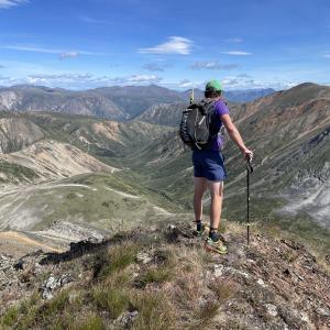
Becker Peak is just passed Tally-Ho and Mount Anderson on the Annie Lake Road. It is in a little mountain complex with Carbon Hill and Mount Bell. The route, like many hikes in this area, is via old mining roads. This road is in much better shape than some of the others in the area and can be partially driven or mountain biked/e-biked to cut off some of the time and distance. From up high on the ridge the views are stunning to the southwest of Mount Crozier and even as far as Radelet Peak near the BC border. Keep an eye for caribou in this area. Note this hike takes you to a more dramatic sub-peak of Becker Peak with great views. The true summit is a more rounded peak, another 1.3 km to the east.
Elevation Gain: 1025 m (3363 ft)
Time: 8 hours
Difficulty: Moderate
Becker Peak is just passed Tally-Ho and Mount Anderson on the Annie Lake Road. It is in a little mountain complex with Carbon Hill and Mount Bell. The route, like many hikes in this area, is via old mining roads. This road is in much better shape than some of the others in the area and can be partially driven or mountain biked/e-biked to cut off some of the time and distance. From up high on the ridge the views are stunning to the southwest of Mount Crozier and even as far as Radelet Peak near the BC border. Keep an eye for caribou in this area. Note this hike takes you to a more dramatic sub-peak of Becker Peak with great views. The true summit is a more rounded peak, another 1.3 km to the east.

Distance: 17 km
Elevation Gain: 587 m (1926 ft)
Time: 6 hours
Difficulty: Moderate
The Berney Creek valley is in the Annie Lake Area and there is an old exploration road that brings you to the alpine and the beautiful turquoise waters of Berney Lake. There is much to explore in this area with good backcountry camping options and extended hiking options. This valley is great access to Mount MacNeil and Radelet Peak. While the hike itself is straightforward to Berney Lake, there are a few challenges. Firstly, the driving access requires fording Becker Creek and the Wheaton River by vehicle as these two main bridges have been removed along the Annie Lake Road. This means timing your trip for when there are lower water levels (mid- to late-summer). The second challenge is that once you start hiking the Berney Creek road, there are about a dozen rockslides that you have to hike across, including one that has taken out the entire road itself. These rockslides just slow you down and require more careful footing.
Distance: 14 km
Elevation Gain: 867 m (2844 ft)
Time: 4.5 hours
Difficulty: Easy
This mountain is located directly west of Tally-Ho Mountain and offers arguably more spectacular views for half the amount of effort. The route is straightforward following a well-maintained exploration road that goes all the way to the top of the mountain.
Distance: 10 km
Elevation Gain: 1215 m (3986 ft)
Time: 5 hours
Difficulty: Difficult
This is a challenging hike in the beautiful Annie Lake Region, along a formidable ridgeline to the summit. There is over 1,200 m elevation gain so this hike is rated as difficult, but the views are amazing along the way of the Annie Lake Region. NOTE: The area falls within Category A Settlement Lands of both the Kwanlin Dun First Nation and Carcross Tagish First Nation. Please respect their rules and land.
Please avoid hiking this trail from April 1-June 15 to avoid disturbing the sheep during lambing season.
Distance: 15 km
Elevation Gain: 1063 m (3488 ft)
Time: 5.5 hours
Difficulty: Difficult
The Mount Skukum area is a Yukon hiker's playground! There are endless opportunities for exploring. Since the two bridges were taken out along the Annie Lake Road, on the Becker Creek and Wheaton River, the area has definitely become less accessible. But once you arrive, it is easy hiking via old exploration mining roads, and the views are rewarding from every angle. Mount Skukum (2,377 m) itself is an impressive volcanic rock complex, and the peak would require rock climbing gear. The hike described here is to a lower peak.
Distance: 29 km
Elevation Gain: 917 m (3009 ft)
Time: 9 hours
Difficulty: Moderate
This mountain is located directly east of Tally-Ho Mountain with some amazing views over the southern portion of the Wheaton River and the extent of Gray Ridge. The route is straightforward following old exploration roads that take you nearly to the top of the mountain. Be warned though, this hike is quite a bit farther than Tally-Ho Mountain, and well worth it if you can tackle a portion of the route by bike or ATV. Alternatively you could tackle this hike as a 2 day trip, camping in the alpine. NOTE: This hike falls within Category A Settlement Lands of the Carcross Tagish First Nation. Please respect their rules and land.
Distance: 5 km
Elevation Gain: 961 m (3153 ft)
Time: 4 hours
Difficulty: Difficult
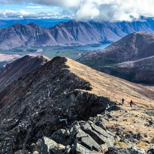
This route is a great challenge. It has it all - steep hiking, bushwhacking, nearly 1,000 m elevation gain, wildflowers, ridge walking, towering rocky pillars, and amazing views. The route is up the north end of what is known as Grey Ridge, a series of peaks stretching along Annie Lake and the Wheaton River (Needle Mountain, Mount Gilliam, Surprise Mountain, Pyramid Mountain and Mount Gray).
Please avoid hiking this trail from April 1-June 15 to avoid disturbing the sheep during lambing season.
Elevation Gain: 961 m (3153 ft)
Time: 4 hours
Difficulty: Difficult
This route is a great challenge. It has it all - steep hiking, bushwhacking, nearly 1,000 m elevation gain, wildflowers, ridge walking, towering rocky pillars, and amazing views. The route is up the north end of what is known as Grey Ridge, a series of peaks stretching along Annie Lake and the Wheaton River (Needle Mountain, Mount Gilliam, Surprise Mountain, Pyramid Mountain and Mount Gray).
Please avoid hiking this trail from April 1-June 15 to avoid disturbing the sheep during lambing season.

Distance: 47 km
Elevation Gain: 2641 m (8665 ft)
Time: 2-3 days
Difficulty: Difficult
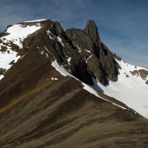
Radelet Peak is a stunning mountain south of the Annie Lake Area with granite spires, iconic couloirs and glaciers. It is such a prominent peak that it can be seen from the tops of many other hikes in the area (Mount Anderson and Becker Peak, for example). This hike gets you up close and personal with the peak by hiking up one of it's beautiful valleys to a viewpoint above the glacier. To actually summit the peak from this valley would require rock climbing or mountaineering skills.
The driving access for this hike requires fording Becker Creek and the Wheaton River by vehicle, as these two main bridges have been removed. This means timing your trip for when there are lower water levels (mid- to late-summer) and having a suitable vehicle with high clearance and 4-wheel-drive. The hike itself involves hiking along the Berney Creek Road, an old exploration road with many rockslides and washouts. After that you climb a pass and head down to the Upper Wheaton River valley on the other side, which requires some bushwacking and route finding. After crossing the Upper Wheaton River, the route follows up another valley to the south with more bushwacking, route finding and potential creek crossing until you can climb up to the viewpoint.
Elevation Gain: 2641 m (8665 ft)
Time: 2-3 days
Difficulty: Difficult
Radelet Peak is a stunning mountain south of the Annie Lake Area with granite spires, iconic couloirs and glaciers. It is such a prominent peak that it can be seen from the tops of many other hikes in the area (Mount Anderson and Becker Peak, for example). This hike gets you up close and personal with the peak by hiking up one of it's beautiful valleys to a viewpoint above the glacier. To actually summit the peak from this valley would require rock climbing or mountaineering skills.
The driving access for this hike requires fording Becker Creek and the Wheaton River by vehicle, as these two main bridges have been removed. This means timing your trip for when there are lower water levels (mid- to late-summer) and having a suitable vehicle with high clearance and 4-wheel-drive. The hike itself involves hiking along the Berney Creek Road, an old exploration road with many rockslides and washouts. After that you climb a pass and head down to the Upper Wheaton River valley on the other side, which requires some bushwacking and route finding. After crossing the Upper Wheaton River, the route follows up another valley to the south with more bushwacking, route finding and potential creek crossing until you can climb up to the viewpoint.
Distance: 28 km
Elevation Gain: 776 m (2546 ft)
Time: 7 hours
Difficulty: Moderate
Red Ridge is a great ridge hike offering several options and fantastic views. The ridge is between other formidable mountains like Twin Mountain and Mount Perkins. Annie Lake can be seen from the top and the ridge follows along the beautiful Watson River Valley. The first part of the hike follows an old mining road for 8 km until you reach the hiking trail up the ridge. A portion of this road is drivable in a 4x4 vehicle with good clearance to cut off some of the hiking distance or consider a mountain bike.
Distance: 20 km
Elevation Gain: 900 m (2953 ft)
Time: 7 hours
Difficulty: Moderate
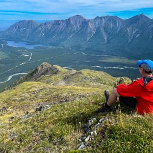
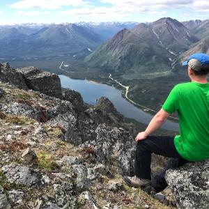
While on top of Tally-Ho mountain, you get a fantastic view down the Wheaton River Valley. The ridge around the summit is completely open alpine which makes exploring easy. It is also prime habitat for caribou, which can often be seen near the summit. The route follows an ATV trail for a lot of the way. NOTE: This hike falls within Category A Settlement Lands of the Carcross Tagish First Nation. Please respect their rules and land.
Elevation Gain: 900 m (2953 ft)
Time: 7 hours
Difficulty: Moderate
While on top of Tally-Ho mountain, you get a fantastic view down the Wheaton River Valley. The ridge around the summit is completely open alpine which makes exploring easy. It is also prime habitat for caribou, which can often be seen near the summit. The route follows an ATV trail for a lot of the way. NOTE: This hike falls within Category A Settlement Lands of the Carcross Tagish First Nation. Please respect their rules and land.