Total Distance: 22 km
Return Time: 8-10 hours
Elevation Gain: 842 m
Difficulty: Difficult
Region: Kluane
Traditional Territory: KFN, WRFN
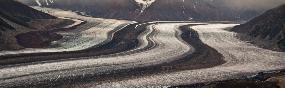
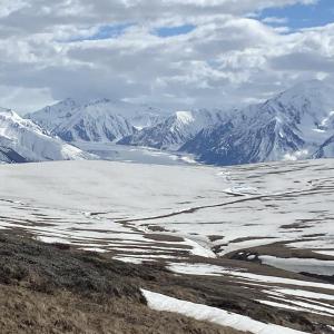
The view of the Kaskawulsh Glacier from the plateau on top of Observation Mountain is stunning. From the viewpoint, you can see the glacier converge around Kaskawulsh Mountain and run straight below you and down the valley. The hike is long and you have to get to the end to enjoy the view, but what a view!
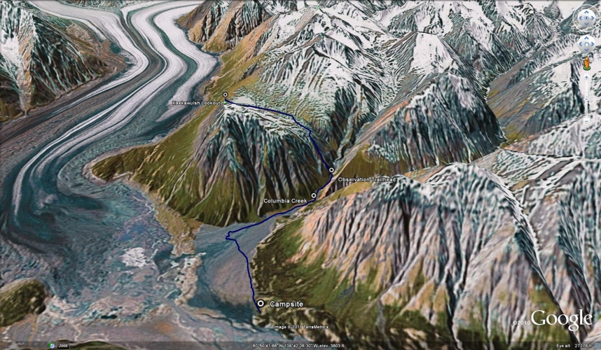
This hike is accessible from the Slim's River West backcountry campground, and therefore requires a 23 km hike in to get to the trailhead. See that hike for directions. Note: Parks Canada requires registration for any backcountry overnight trips in the park.
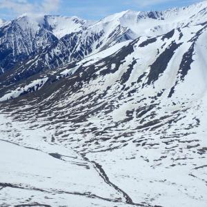
Start from the campground of Slim's River West trail and walk southwest to the base of Observation Mountain until you reach Canada Creek. The creek is braided and will have to be crossed multiple times. If it is really deep, you may have to head to your left (east/downstream) until it is braided enough to cross. Cross all sections of the creek until you get close to the mountain (just under 3 kms from the campsite) and then walk upstream (west).
Continue following up Canada Creek until you reach another creek which flows in from your left. This is Columbia Creek. Turn left (south) to follow along the left (east) side of Columbia Creek. There should be rock cairns along the way to guide you up the creek. From where you started to follow Columbia Creek, it is 1.2 kms to the trailhead up the mountain (the Parks Canada website says it is 500-800 m to the trail, but this is wrong). If you don't have a GPS, an easy way to gauge where the trailhead is, is to look up Columbia Creek for a treed slope on the right which comes down to the creek bed. The trailhead is on the left, shortly after this treed slope. If you were to continue walking on the left side of Columbia Creek past this treed slope, you would soon hit a rocky cliff which comes right down to the creek bed and would force you to walk in the creek. The trailhead is just before that cliff.
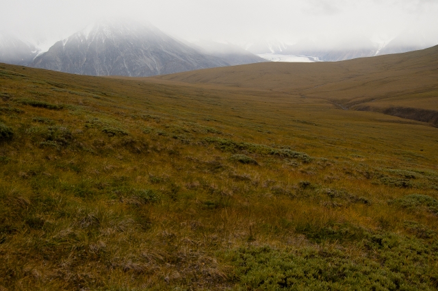
The trail becomes steeper now as you climb up to the rocky ridge. The views of the valley below open up and are fantastic. Follow the ridge up to the vegetated mountainside where the trail climbs steadily up. Soon the trail will become faint, and will head to your right (west), cutting across the mountainside.
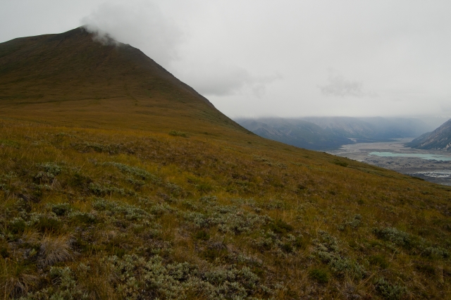
Cairns will mark the route, but if you lose the trail, just pick your way up to the top of the ridge (heading to your right as much as possible). On top of the ridge is an open plateau. You want to traverse this plateau (south) for 3 kms to the end where the Kaskawulsh Glacier lies beneath. There isn't much of a trail, so just walk across the open plateau towards the glacier (you should be able to see a bit of it by now). At the end of the plateau, rest and soak in the view. When you're done, follow the same way back so you don't end up over a cliff or bushwhacking for hours.
You can also climb to the top of Observation Mountain from the plateau if you feel like it (this will add time, distance and elevation gain). You can't see any more of the glacier, but you do get a view of the surrounding valleys and mountains.
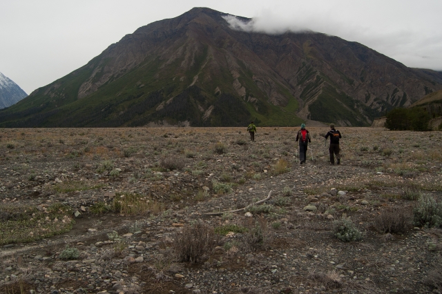
Start by walking towards the base of Observation Mountain until you reach Canada Creek.
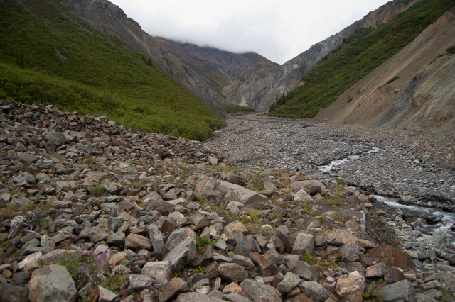
While you walk up Columbia Creek, look for the treed slope on your right. The trailhead is just up from the trees, but on your left.
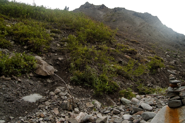
This is the start of the trail up the mountain. It is well worn right down to the creek and should be obvious once you reach it.
Hiking along the rocky ridge.
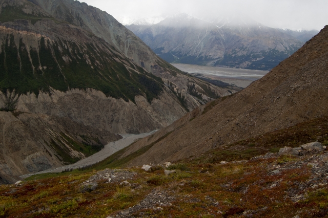
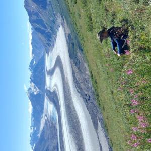
Looking back towards the Slim's River with Columbia Creek in the valley below.
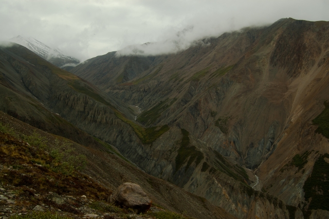
Hoodoos and beautifully decorated mountain slopes to the west of the ridge.
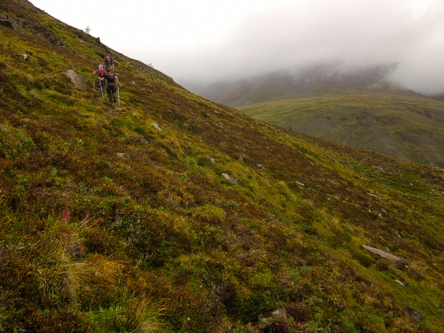
After the ridge, you will be hiking on softer ground. The trail becomes less visible as it continues up the mountain.
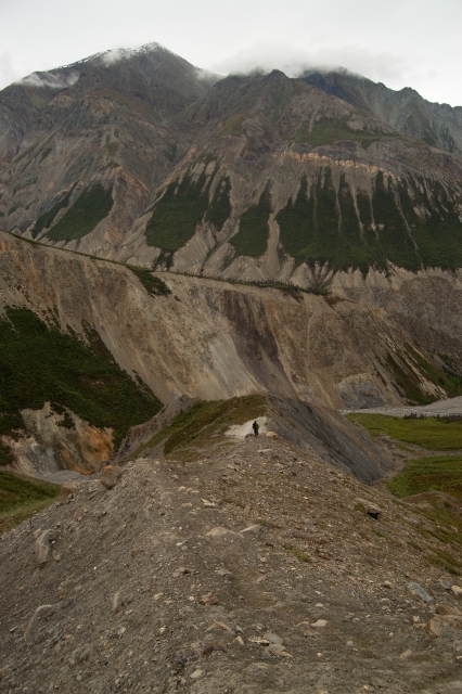
Looking down the open plateau towards the viewpoint. Once you reach the plateau, you have 3 kms to the viewpoint.
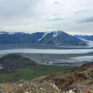
You can also hike to the peak of Observation Mountain. This is looking towards the toe of the glacier.
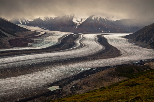
The mighty Kaskawulsh Glacier.
CM June 14, 2024
Completed Observation on June 9th, 2024. Too much snow to get super close to the glacier via the pass, but still saw part of the glacier and made it to the start of the pass with some post-holing the last 500 meters or so (see photo). Finding the "trail head" requires some nav as it is no longer worn down to the creek bed. The edges of creek bed have worn away and what used to be the trail head in the pictures above, no longer exists. Depending on the creek height you might have to do some light bushwhacking to get to the "trail head" as the creek may be running in an area that is usually walkable. Someone did build a Cairn at the trailhead, so if the creek isn't super high you might be able to see it. I highly recommend taking the time to try and find the trail head. Once you find it, it is straightforward to follow and the other options up onto the ridge are sheer & sketchy.
If you can find the trail, the difficulty of the hike itself will depend on weather conditions. Some of the steeper sections were hard and dusty - not really any scree you can sink your feet into for support - so it could take some time to maneuver your way up or down. I imagine that rainy days must be hell on that mountain. Once at the top, the way into the pass is straightforward, as long as there is no snow.
We saw grizzly prints all the way up the mountain trail and then saw a grizzly up at the top as well. The bear was fairly close but decided to leave us be. Be bear aware up there! At one point we saw some post holes through the snow and thought it was another human, we walked over to use their post holes, turned out to be a grizzly taking the same route a human would.
We did not get the alpine start recommended for this hike and paid for it later. It was fine the way in, crossing Canada Creek around 10:40am ish, I would say the creek was knee height. Coming out however, we were very late in the day. If I could do it all over again I would have brought our tent with us and set up at the base of the mountain. That way, if you cant cross the creek at the end of the day, you at least have your tent and food. Apart from our 10am start out of camp, the sheer length of this hike means that if you encounter any obstacles (a bear, snow, nav issues) you could be pushed into a dangerous timeframe for the creeks. By the time we got to Columbia Creek on the way out, it had grown significantly. I’m not talking a few CM. I’m talking, going from a dry creek bed we walked up to a very fast, waist deep ranging river. The crux of this hike is definitely the creeks and the timelines that go along with safe passage.
During our stay in the Slims River Valley we met some ladies who opted to walk to the toe of the glacier instead of going up Observation. That would also be a nice day trip, especially if there is still snow in the mountains. In the end they were able to get much closer to the glacier than we did!
Overall, a hike to remember.
Nallely September 6, 2023
Completed this hike from September 2 to September 4, 2023 (Slim River West + Observation Mountain summit).
The Slims River route is pretty easy to follow, with some wet spots at the beginning of the trail, but the whole group had good waterproof hiking boots. On day one, to cross Sheep Creek there was no need to take the boots off, as there were multiple rocks by the cliffs to jump on. We crossed Bullion Creek around noon, water levels knee high and with hiking poles for stabilization, no challenges. There is no water close to the camp anymore, after setting up camp we walked to Canada Creek to get water and to check the water levels around 7 pm. The creek was pretty fast-moving and high, we did not attempt to cross but found a spot down low that looked wide and the water was more spread out. We crossed the next day at around 8:30 am, water was knee-high and not as fast. On the way back, the water was above the knee and pretty fast. We crossed closer to the cliffs using a line astern formation and entered the water with the strongest person facing into the current to help break the flow and the second person helping to stabilize the first. We were a group of four, so two crossed first and then the second group.
For day three, we crossed Bullion Creek at around 1 p.m., the water below the knee, and no challenge at all. Sheep Creek later, again with boots on, jumping on the rocks.
On day two we saw a black bear right after crossing Canada Creek on the way back, and a grizzly on day three before crossing Bullion Creek, so stay together and bigger groups are recommended for safer fun and enjoyment. The views are amazing, but it is a difficult hike.
Andrii Ledok August 7, 2023
We just finished this hike. From parking it is much longer road. This trail begins from campsite. It was not easy to cross Bullion creek. We can't cross it downstream and it was easier upstream. Canada creek was much easier to cross at 8 and 9 am. Just don't leave your staff at the other side of Canada creek. Some people stuck becouse that can't cross creek in the evening. This trail in general so wet: wetlands, creeks, mud and can be difficult to cross creeks when it rains. You can camp even on amazing green field with a view from observation Lookout. Just always check weather. If it will be sunny it's ok, but be careful about thunderstorms or strong wind. If I knew before that there lots of places at viewpoint to glacier I will take my tent. If you decide to do like this, it is good to do in 3 days: 1- parking to campsite, 2 campsite to viewpoint, 3 back to Canada creek and night before to cross creek in the morning. You can find also good places. Just be careful and dons stay on lover areas. Choose dry one and more up. We slept at the place a bit higher where Canada creek and Columbia creek become one creek. We took also crocs and waterproof socks Just to cross rivers. And we just made a shortcut by huge gravel field and it was much easier to go back. But you need a proper shoes. This hike in general not for beginners.
Sophie July 11, 2023
We did this amazing hike (Slim River West + Observation Mountain) July 7-9 2023. The trail is easy to follow and the view from the summit is incredible.
To cross Canada creek in the morning, we went as left as possible were the river is braided. When we thought we were done with the crossing, we hit a wall. The river changed its course and is now coming against a cliff on the left side. So we had to bushwack for an hour in the forest. Which was okay but really not fun. The trail is then easy to follow. On our way back, we decided we were to tired for bushwacking so we crossed the creek more upstream, before the cliff. The level was hip deep for the shortest person of the group, and the river was quite fast. We were 5 people so we managed to cross without trouble but it was definitely challenging.
Right now, everything is really dry. There is no water at the camp and there is just one clear creek on the way to Observation Mountain.
Janille September 6, 2022
Completed this hike on September 4th. It was a beautiful day. The Canada Creek crossing wasn't challenging at all - not a lot of change from morning when we left to our return trip (just below the knees). Only had to cross the upper stream where the cairns where, and the spot wasn't too bad at all.
The trailhead was easy to follow. The first kilometre up had some signs of wildlife, such as bear poop and a bear dig just by the trail, but no bear sightings.
Went all the way to the summit and it was amazing! Definitely worth it to go to the summit for the views!
Just a note that the campsite doesn't have a water source at all (if you don't mind a small pool of still water, you might be able to find one 300 feet near the site). The closest water source we had was just near Canada Creek so if you are camping, I would suggest to fill up by the boardwalk before your ascent to the hills.
Shailyn August 19, 2022
Hiked on august 14th. This was the best and worst hike of my life.
The views were truly stunning, but unfortunately I went on a very terrifying swim in Canada Creek on the crossing back to camp after, despite spending about 45 minutes trying to find the most shallow braids. The flow of the channels had easily doubled and the depth went from about thigh high (when we crossed earlier) to hip high (on our return), and it was impossible to bushwhack to a more braided channel downstream (due to the cliff along the creek). The trail was truly wonderful. We went to high up in the plateau and would have been better off staying low, but it meant we have views of the glacier for longer. Overall it took us about 10 hours, but that is also because of the creek scoping and accident. No signs of wildlife (except one Pika up high).
James August 14, 2022
Hiked it 2 days ago. Crossing Canada Creek on the return is more challenging right now. The creek runs right up to the mountain and into the trees. It is not possible to get where it fans as per the gps trace. The water is very muddy at the end of the day so you can't judge depth at all. The current is extremely strong. That being said, it is was still crossable, just really scary. Also make sure to filter your water in the morning. In the evening, there is just too much silt for the filters.
k July 5, 2021
Hiked it this weekend, on a bluebird day. What an amazing hike! The extra effort to the summit was well worth it, after enjoying a nice long break on the plateau. Crossing Canada Creek went well, even as a solo hiker, as I made sure to keep my good trail shoes on. I crossed the creek where it was braided at 11:30AM, and then later in the evening (8pm-ish?). Although it was running high, I was able to find spots where the water was not as strong as Bullion Creek the day before, for reference. The wildflowers were beautiful, and I saw some goats from the summit. Keeping the GPS tracks handy was useful just in case, but I found it pretty well marked with cairns, at least for a Yukon route...
m+d June 22, 2021
Did this hike on the solstice. We opted to cross the boullion and canada creek where they were more braided because we heard they were running high and fast. It was about knee deep. There were a few snowy patches on the way to the lookout point, but they could be avoided. The summit trail looked like it still had some snow on it, but we didn't check it out closely. The water at the campsite is very murky so you might want to fill up at the boardwalk before you start the final ascent to the capsite, and in one of the streams on your way back from canada creek.
Laura June 20, 2021
Great Hike - did it yesterday!! The plateau is clear of snow (a few small patches on the way up that you can easily skirt or go through). Canada creek was no problem when crossed around 9:30 and again at 3:30.
Jenna September 16, 2020
Did this hike from Canada Creek on July 31 (hottest day of the summer) - we were the only ones on the trail that day. Saw no wildlife. The braided creek crossings gave us no problem (though the water is VERY cold), and the route was fairly easy to follow, though it took longer than expected to get to the base of the mountain trail. Overall it was a long and challenging hike, especially in the heat, and especially after the long 23km hike with packs the day before - we did not make it back down the mountain in time to cross Canada Creek before the sun went down (~11pm) and opted to wait out the darkness on a rock bed by the creek, then crossed at 530am back to the campground. We would have been very cold in the night if not for our emergency blankets - I'd highly recommend bringing these or ideally a sleeping bag on the hike in case your trip takes longer than expected, or if the creeks are too high to cross when you return at night (we spoke to two groups at the campground who had pretty high waters crossing back at 9/10pm the day before, another reason we opted to wait until morning). Overall, this was an awesome experience - but I'd recommend leaving as early as possible for the hike, being prepared for waiting out creeks, and considering adding some time to the full Slims River valley hike - we wished we'd planned 4-5 days overall for Slims and Observation, to be less tired and enjoy it all even more.
Christine August 31, 2019
Hubby and I hiked this beginning of July last year. We did this in three days, hike to camp, up Observation and back. We crossed Canada creek a few kms with my husband in front of me which reduces the power of the current. We also unbuckled our packs as someone died there in 2015 trying to cross. We had a grizzly approach us during a break about 8km in. We had the spray ready but he was more curious then threatening. It approached within 30ft then did a bluff charge and ran off. We ran into several other hikers who all saw a grizzly so hikers must be prepared. The hike to observation was amazing. We spent an hour on the plateau and ended up getting a canvas done of one of our glacier pics. The hike down is scary for someone with a fear of hikes (aka me). It was very windy and from the ridge you look straight down. If you have a fear of heights you have to do this hike to see the glacier because who knows how long it will be around BUT the way down sucks. The hike out on the 3rd day was a breeze as you can sadly now walk where the river once was.
Felix Ossig-Bonanno June 12, 2018
Got back from this yesterday, so was up on the 10th. I think I was first on the summit this year... still lots of snow and I didn't see any other tracks (to the top. someone had been up onto the plateau). Expect some post-holing... I went in up to my waist a couple of times. I'll attach a photo of the plateau to give an idea of snow.
kyliestravel August 22, 2017
Did this hike as apart of the slims river trail on August long weekend (discovery day). The information may be a bit outdated, as there is only 1 river to cross. The hike is steep and is very easy to get lost on alpine - I met parks canada guy up there who was looking to review the markings of the trail - so fingers crossed.
Yukon Hiking July 5, 2017
Hi Toby, yes, as with all our hikes, there is a GPS track available for download via the link below the Google Map near the top each hiking page.
Toby July 3, 2017
Is there a GPS Track available?
Darren June 16, 2014
Was up here a few days ago. Creek crossings were fine. Be sure to use the directions here and not the ones from Parks Canada, as they are confusing.
Overall, a great area that I'll surely return to (particularly because I got lost and did t see the glacier!)
