Total Distance: 8 km
Return Time: 4.5 hours
Elevation Gain: 1000 m
Difficulty: Moderate
Region: Carcross
Traditional Territory: CTFN
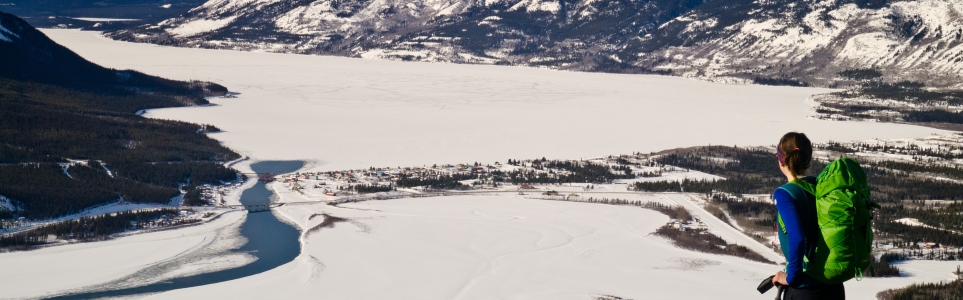
Nares Mountain is a beautiful hike with views over the community of Carcross and Nares and Bennett lakes. Don't be fooled by the short distance and duration for this hike, the 1000 m of elevation gain can definitely kick you into shape.
Please avoid hiking this trail from April 1-June 15 to avoid disturbing the sheep during lambing season.
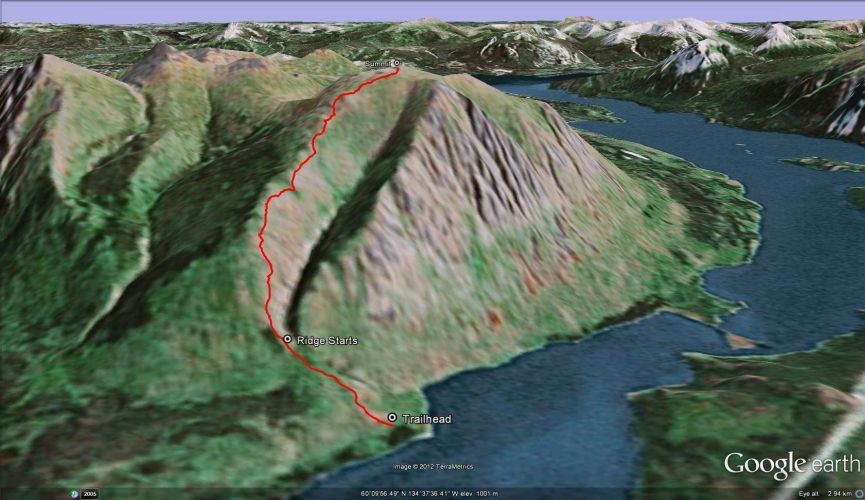
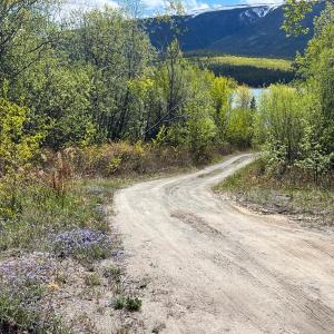
Just north of Carcross on the South Klondike Highway, take the Tagish Road northeast for 2 km until you see a green sign for Choutla Subdivision on your right. Take this road through the subdivision, staying right at the fork. After 1 km you will reach a narrower road leading off to the right called Blattas Point Rd (there is a big yellow dead end sign). Follow this road for 2 km to the very end where it ends at a private driveway. Park in a small parking area just passed the driveway on the left.
NOTE ON PARKING & PRIVATE PROPERTY:
Do not block the driveway and ensure larger vehicles and trailers can still access the driveway. Please do not trespass, the driveway and property are private and are not for public use.
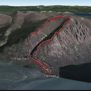
Note that this route follows up the left ridge to the summit, and while not the true summit of Nares Mountain (which lies due north), this route is more accessible and the views are arguably more dramatic from this vantage above the lakes.
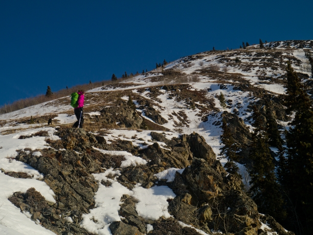
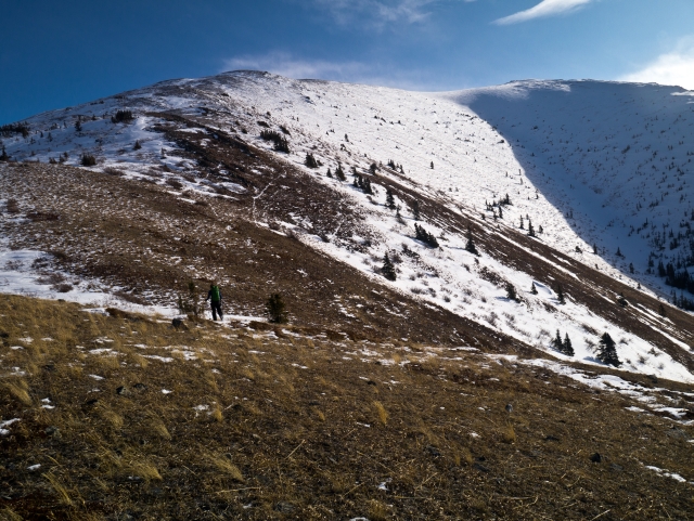
From the parking area, look for a trail just slightly ahead (not the ATV trail that goes straight up from the parking area). Note you're aiming for the left ridge, and you may see a path that leads to the right ridge, but don't follow that path unless you are planning on doing a larger loop route (described below). Stay on the left side of the main gully that comes down from the mountain and towards the lake, passing through a willow and poplar stand at the base of the mountain. The open ridge stretches out in front of you and the climbing begins. The bonus is the views get better and better as you hike higher and higher up.
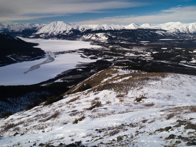
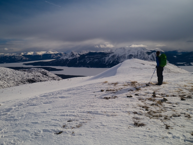
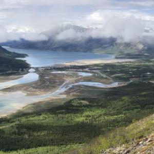
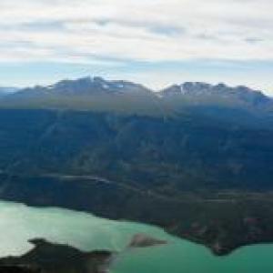
Once on the ridge, the route is straightforward as you essentially follow it to the summit. Some side hilling may be required along the south flanks/right side of the ridge in order to avoid any treed areas or unnecessary ups and downs. Once at the top there is a plateau that stretches off in several directions each offering a different perspective. From the main high point there are great 360 degree views. Towards the southwest of the summit, there is a little rocky point that looks down to Nares Lake and across to Montana Mountain. There's also another point to check out to the southeast with great views of Tagish Lake, Bove Island, and Lime Mountain (with it's distinctive light-grey dolostone and limestone rock face).
Sheep and deer can be seen in the area and the area is also known for its Dusky Grouse population. Once you've finished exploring, enjoy the view on the way down by returning on the same route you came up.
EXTENDED LOOP OPTION:
There is the option to do a loop down the other ridge to the trailhead. It is a shorter route down (or up) and a bit more narrow and rocky at times than the other side of the ridge. The views are great here too.
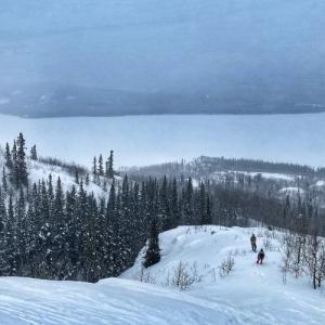
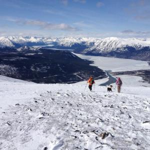
The Blattas Point Rd is often plowed in the winter, but keep in mind if it's not you will have to walk the 2 kms to the trailhead. Follow the same route as the summer route described above. As mentioned earlier, much of the ridge is bare for the most part through the winter; however it may depend on the time you choose to go and how the weather has been (i.e. new snow, strong south winds and sun). The deepest snow you would likely encounter is at the base of the mountain in the poplar and willow stand. Snowshoes shouldn't be necessary; however, at least gaters would be useful in keeping any snow out of your boots. The summit itself is fairly windswept with hard packed snow and again snowshoes should not be necessary.
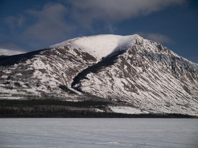
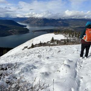
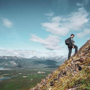
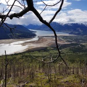
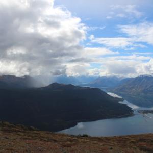
The view of Nares Mountain from Carcross. The route described follows the left ridge to the summit.
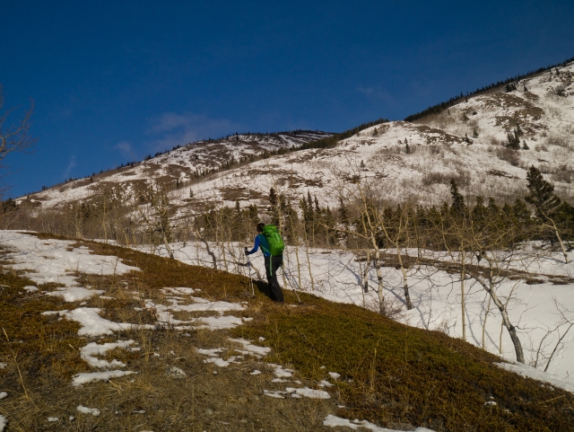
Heading up the gentle, open slope towards the base of the mountain.
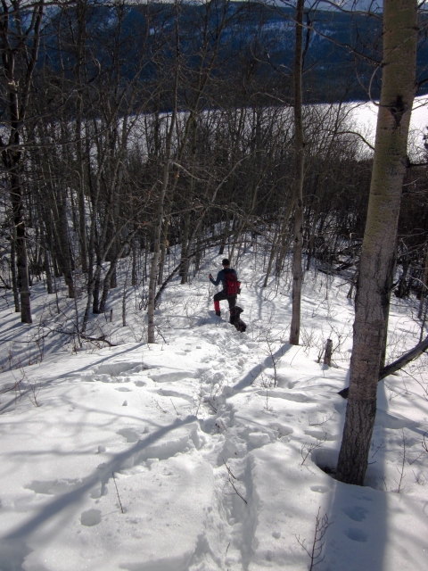
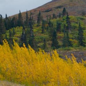
Walking through the poplar and willow stand at the base of the mountain. This is likely where the deepest snow will be in the winter.
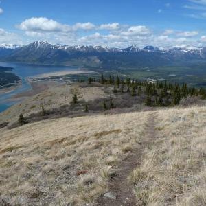
The beginning of the ridge... it's all up from here!
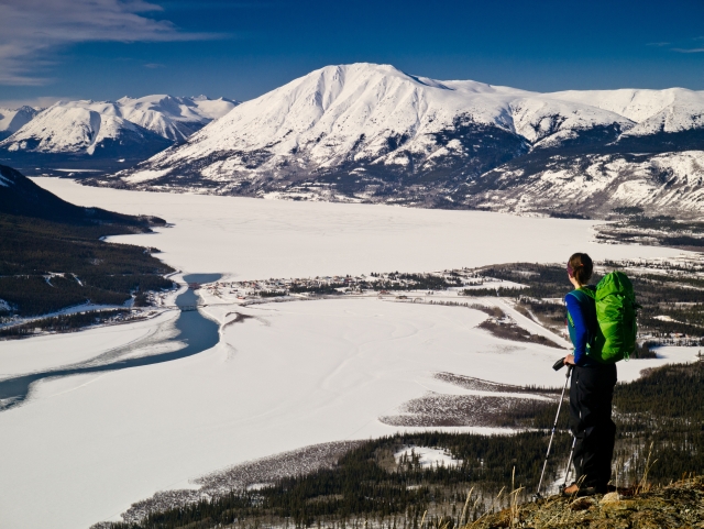
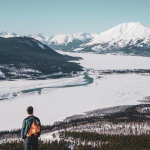
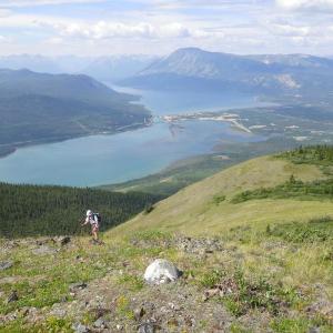
Looking towards Carcross with Bennett Lake and Nares Lake below.
Getting closer to the top of the ridge.
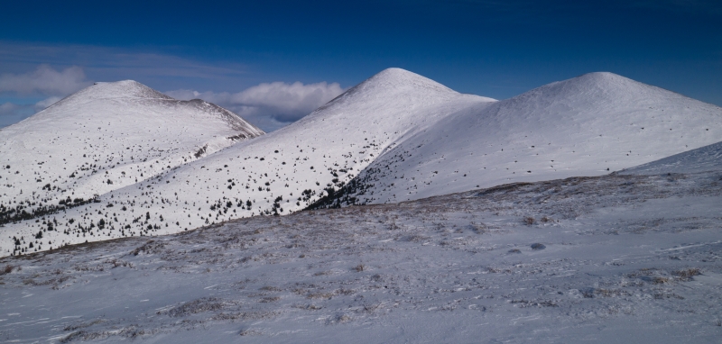
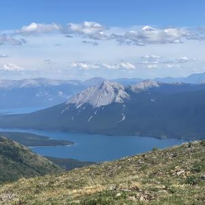
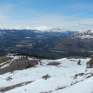
The view north, looking at the true summit of Nares Mountain (the peak in the middle, 1768 m).
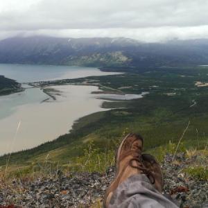
The view from the summit looking west.
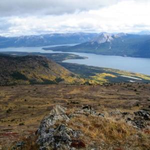
The view from the summit looking east towards Tagish Lake.
Ann July 6, 2026
Hiked it on July 4th. Trail is all clear to the summit. Two large patches of snow closer to the top that are off trail but a nice reprieve for puppy friends. Parking area is pretty well marked.
KCMGH July 28, 2025
Completed this beautiful hike today! A fairly easy start that does turn into a decently steep ascent with some challenging terrain to navigate (loose rocks, sandy, brush, etc.). Quite hot under the sun with minimal shade opportunities so bring a hat and sunscreen if the sun is out. Amazing views at the summit, well worth the trip up; though there was lots of flies so pack bug repellant as well. Bring poles!
Julie July 27, 2025
I spotted a bear with three cubs on July 26. They weren’t on the trail but were visible in the distance on Nares Mountain. Sharing this so people are aware and can stay alert while enjoying the area. Happy Hiking!
Yukon Hiking June 9, 2025
The property owner near the trailhead has put up more signs to show NO TRESSPASSING and to DO NOT BLOCK DRIVEWAY. Please respect the landowners that live in this area.
Yukon Hiking January 9, 2025
NOTE: Please ensure you are parked well clear of the private driveway, and that large vehicles and trailers can get in. The driveway and property are private and there is to be no trespassing. Please respect the landowners that live in this area.

Yukon Hiking October 4, 2024
Hiked the loop on Wednesday and had the route to ourselves. Quite a bit of snow on the upper 1/3 of the mountain (5-10 cm). Trail difficult to follow at times with no other footsteps! Still managed the loop in 4 hours. Enjoy!!!
Keith C July 30, 2024
Hike Nares on July 28, 2024. Loved it! It's a nice challenging hike, yet not difficult bc there's a path (sometimes a bit faint and braided) and the ascent has a view of the summit. Very high pay-off soon after you start clearing the woods. Near Carcross so help shouldn't be too far. No scree or scrambling.
Just make sure to bring poles (helps with the sometimes steep and sandy descent). And budget more time! There's a plateau at the summit and lots of vantage points to explore. A sea of mountains!
Lisa July 20, 2024
Just texted you :)
Doug July 16, 2024
Hi Lisa,
They are mine!! We put a post on happy hiking Facebook, can you contact me at 867 333 3102
Doug
Doug July 16, 2024
Hi Lisa,
They are mine!! We put a post on happy hiking Facebook, can you contact me at 867 333 3102
Doug
Lisa July 7, 2024
Hiking poles found about 2/3 way up Nares July 6, 2024. Post here with a description.
Sunnysideup July 14, 2023
Well it took us 7 leisure hours, including lunch, a nap, then tea and cookies at the top and another short nap. Going down is hard on the knees, but hey ho. We made it. Incredible views, complete with mountain avens at the top.
Steph February 22, 2023
Hiked Nares today, made it 2/3 up due to time constraint. Snowshoes were not necessary, but there’s some very small sections where we sank in knee deep (sheltered areas between trees). I definitely recommend gaitors and/or shell pants. I wore soft Neo Overboots, it was quite slippery in those, cause I couldn’t „hammer“ them in in the steep sections. My partner wore stiff mountaineering boots and was perfect. Access road was fine in our low clearance 2WD, just be mindful when parking in soft snow. Gorgeous views.
Fraser September 2, 2021
Hiked in August of 1979. Easy stuff.
Yukon Hiking May 18, 2021
SEASONAL CLOSURE INFO We've received requests over the years to share info about seasonal closures from the Carcross Tagish First Nation and the Carcross Tagish Renewable Resource Council. The hikes in question are all within the CTFN Traditional Territory, and that is why there is no official closure for Kusawa, which is not in their territory. As hiking interest and traffic has increased over the years, there are concerns for the sheep and goats during the sensitive lambing and kidding season. As such, they have asked hikers to stay away from April 1 to June 15. Of late, the Yukon Government and Wild Wise Yukon have also been promoting educational campaigns about sheep lambing and goat kidding season across the territory, and asking hikers to be considerate of this sensitive time. There is also a lot of concern from all sides about hiking with dogs off leash.
Tom Sawyer May 13, 2021
I would like to know who decides and regulares access to alpine areas? It seems to be a bit arbitrary. Just a few years ago it was caribou and white mountain which i can understand due to the large population of sheep, goats. But lately, it seems to be more and more hikes so why nares and not kusawa ridge? I hiked Nares at this time of year in the past and seen literally two sheep. I did Kusawa last year and seen quite a few sheep yet there was no suggestion to not do the hike. Who decided that we should not be there at this time of year? Is this mandated by dep. Of environment?
Manon May 13, 2021
Where do we find the trail closure information for the sheep lambing season....
Yukon Hiking May 5, 2021
Simon, please observe the SEASONAL CLOSURE for this hike during the sheep lambing season. People are asked to not hike here from April 1st to June 15th. Same for Caribou Mountain and White Mountain.
Simon T Woods May 5, 2021
Has anyone tried to hike it this spring? I am planning on doing it tomorrow and am wondering what the snow situation is. Any beta is apprecaited!!!
Marianna February 21, 2021
We attempted to hike Nares yesterday, Feb 20, 2021 but the conditions weren’t the best. The 2 km drive on Blattas Point Rd was very easy, plowed no need for AWD. From the trailhead, there wasn’t any visible trail due to the amount of snow we had this winter and possibly blown snow. We had to break trail in deep snow. I used the GPS tracking but we managed to stay on the trail just by looking ahead and find the most sensible way to get the to base of the mountain. Eventually we found some sections of the packed trail but covered under fresh snow. We made it to the first flag but after that, it wasn’t possible to continue. Breaking trail on a very steep section is not that fun but honestly I tried it anyway. It required crawling up on the mountain side, to avoid sliding back. The views were still beautiful despite the low visibility and snow. At least I can say I tried my best. 😊
Mountain Man October 11, 2020
Fantastic hike on a beautiful fall day!! Steep all the way up!! Trail is fairly easy to spot but can be lost in places once out of the trees. Explored the south rocks and had wonderful views of Nares and Carcross. Wouldn't have done it without poles. A few patchy spots of snow at the top but otherwise dry. All in 7 hours but at a very slow pace to take in all the beauty!!
Sam July 31, 2020
Hiked Nares 29th July, lovely well worn trail, steep in parts but once up on the open ridge it’s smooth sailing. Not as steep as Caribou Mtn imo. No bears or bear sign, epic views from the top but a little hazy today from the wildfire smoke. If I was to do this hike again, I’d go to the true summit and do the traverse as suggested by Darren below.
Megan July 30, 2020
Attempted to hike Nares July 28. A few minutes into the hike, we saw a bear grazing up far away on the right ridge. 30 minutes into the hike, we came over a ridge to meet another black bear on the trail about 30m away. He did not care that we were there and continued on with his berry party. For over an hour, we watched him from afar but he was very content on the trail. We decided to try Nares another day and let these beauties carry on undisturbed.
Darren July 14, 2020
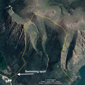
If you want a bit more of a challenge and have 2 cars, I'd recommend a full traverse of the mountain. Added benefit is if you do it, you can hit a sweet swimming spot at the end. Basically take the regular route, and when you're cool with it, just cut left and hit the peaks. It's easygoing terrain. Dropping down from the actual peak to the far left one is a bit of work, but it's still a great route. Minor bushwhacking from the far left peak to the swimming spot, but nothing too wild.
Pat T July 13, 2020
Challenging uphill battle the whole time but the views are incredible. The group in front of us heading down said that a large grizzly was following them for 20 minutes and it took 6 people to eventually scare it off. Be aware of the bears in the area!
Liz B June 22, 2020
Hiked Nares on the solstice, it took us 2h 15min to get up and 1h 45min to get down. There are lots of different trails that intersect along the ridge but it doesn't really matter which one you take since they all meet up eventually. We began hiking at 10 am and had the summit to ourselves. On the way down we passed around 12 groups of people. No signs of wildlife (not that I would expect any with the amount of people on the mountain). The wind was pretty intense but it kept the bugs away so I can't really complain. This hike is a good leg burner, my hiking poles were a big help for my knees on the way down.
LizB March 17, 2020
My husband and I attempted to hike Nares on Sunday. We made it about halfway up the ridge before deciding to turn back. The ridge is not very wind scoured so there is still a significant amount of snow. It was getting very difficult to climb the steeper ridge sections in snowshoes and it would have been near impossible to get up without snowshoes. If you plan on hiking Nares anytime soon, BRING SNOWSHOES and good luck.
Erin November 26, 2019
Hiked Nares on Sunday. Beautiful day with great views. Trail easy to follow. Some ice at the beginning which cleats helped with. Gators were useful in some snowy parts, no snowshoes needed.
Ryan September 4, 2019
Hikers should use caution. There is a black bear and cub in the area. Please don't let a situation arise where your safety is at risk, but also the safety of the bears.
Ryan September 3, 2019
Hikers should use caution. There is a black bear and cub in the area. Please don't let a situation arise where your safety is at risk, but also the safety of the bears.
Christine August 31, 2019
Hubby and I hiked this today. We went up the left ridge, saw some Dall Sheep and a black bear in the distance. We recommend really taking a look out on the plateau with binoculars as you never know what you will find. We went down the right ridge which was the best way as I imagine the left ridge would be a bit slippery on the way down as it is quite worn and sandy. We are avid hikers and found this hike had us a bit breathless on the way up but it was a relatively smooth hike.
2 Old Boots August 5, 2019
The views are gorgeous so well worth the hike. We saw a large black bear while walking down near the top and was able to skirt him. He was very busy enjoying the berries! We would recommend having poles, bear spray and making lots of noise. Took us about 3 hours to walk up and 2 to get down. We would rate this as a more difficult hike as it is basically all uphill and quite steep. Great cardio!!
We hiked the left side only. Was fine going up but we lost the trail for a bit in the trees on the way back down.
Cata March 27, 2019
Hiked it with my dog today. Last summer I took the right ridge up and really liked it, I feel you get a better view all the way up, steep but fast. This time I took the left ridge and it felt longgggg, probably because I'm out of shape from the winter but still I prefer the other way up.
Snow in the last section of the trail up to the top, sinking a bit but not horrible. Saw one eagle and it was a beautiful day for a hike :)
Matt June 10, 2018
Great hike today. Took a good look at the mountain from Carcross and could see the top was snow and fog-covered, so tempered my expectations and decided to not go the whole way up. For a first-timer, with a deliberately heavy pack (training), it feels like this was a wise move. The climb is indeed steep in places, I could not imagine attempting this without poles. I only made it about 2.5K up (of the full 4K) before calling it due to being fogged in and wanting to return injury-free in one piece. This hike might be "Moderate" due to it being not particularly long, but there's definitely some borderline scrambling in places. Not recommended for a spontaneous "wouldn't that be fun" hike, unless you're in good shape. What's really awesome about the hike though, is that you're rewarded with great views looking back to Carcross after just a few hundred metres. Keep climbing and the views keep getting better, but your eyes will be glued more and more to your feet. One note on the driving directions. There may be a "big yellow dead end sign" on Blattas Point road, but it sure is well hidden. The road looks like a private driveway and the sign (as well as the Blattas Point Road sign) is several meters off the Choutla Subdivision Rd. Maybe it's super obvious in the winter, but drove past it the first time around. The trick is to look to your right as soon as Choutla Subdivision road tries to turn you left and head uphill. If you do that, you've missed it and are headed back out as it's a big loop of a road.
Shailyn June 3, 2018
Hiked up Nares with a friend today. Turned out to be a stunning day for the hike (not too hot, some wind to cool us off). Went up the left ridge and down the right. Stunning views the whole time. Fair number of people out on the trail enjoying the day too. No wildlife sightings besides a beautiful Bald Eagle. Trail was in great condition.
Kyle May 23, 2018
Views from yesterday
Kyle May 23, 2018
Did this hike yesterday. Very steep but it is unique in the sense that from the very start to the end of the hike you are rewarded with great views of the lakes. The trail is in good shape, the summit is very windy and cold, some snow patches but nothing you have to walk through. The views from the summit are stunning, looking down on carcross, bennett and nares. You can venture at the summit to the other side and take in another stunning view of Bove Island and several bodies of water as the birds of the summit sing to you.
Randi Newton April 9, 2018
Went up Nares yesterday, heading up the right ridge and down the left. Snowshoes would have been a huge help (I seem to make the same mistake every spring and leave them in the car for a hike I should really take them on). On the right ridge I was postholing in some sections up to my thighs. To avoid the snow I stayed on rock as much as possible which made the ascent more of a scramble than a hike.
Heading up and down the left ridge without snowshoes is definitely doable although microspikes wouldn't be a horrible idea.
MM November 13, 2017
Saw a group of sheep low on the ridge on Saturday, so opted to go up the right ridge instead so as not to disturb them. Lost the trail a few times through the trees and under the snow, but otherwise pretty straightforward.
Dan & Donna September 11, 2017
Great hike! Steep but fun and well worth it for the views.
Saw a bear running from left ridge to right ridge near the beginning of our hike but never saw it again.
Great fall colors are starting to show. Quite windy and cold at the summit area.
Lisa September 4, 2017
Beautiful fall hike with stunning colours and views. Hike up is steep with loose rocks and poles recommended.
Jessica June 29, 2017
That was one of the best trail I ever did ! Really steep but the wiw worthed it !!
kyliestravel May 28, 2017
We hiked in quite a big group on Sunday 14th May. There were only a couple of small patches of snow left. We did spot a mum and 2 cubs on the right ridgeline prior to the hike.
We were lucky with no wind at the summit, but was quite overcast
Glenda May 3, 2017
The trail was almost completely free of snow on the north ridge and mostly free on the south ridge yesterday. You might want to ascend and descend on the same side rather than doing the loop. We could walk on top of the snow, but others had sunk deep on a warmer day.
Shannon Wyers April 18, 2017
Please be bear aware!! My friend and her hiking partners spotted a sow and her two cubs approximately 1 km up Nares Mountain on Saturday, April 15. 🐻
Alison April 18, 2017
Hiked Nares Mountain on Saturday April 15th. Lower half is clear, but higher elevations had sections of snow that we had to go through, and a lot was soft so we sank in a number of times - knee deep or higher often. We climbed to about 1 km from the summit; hikers ahead of us said the last section to the summit was unavoidable knee deep snow, and we didn't have the right gear on for that. Took us 5.5 hours with a snack break, lunch break and many stops to enjoy the views and catch our breath!
Jo October 30, 2016
Hiked Nares Mt on Sun Oct 30th. Good trail up to treeline in dusting of snow with snow increasing to up to 40cm in pockets at different spots once on the ridge. Tons of sheep track and bedding sites but no sightings. Always impressed how quickly one gets up in the alpine with amazing views around here. Great hike!
Kat September 14, 2016
Trail was great! once you get up to the top there is a lot to see! It took us 6 hours to go up and down, but we stopped a lot to enjoy the fall colours. Great hike but next time I am bring poles.
Tatlow September 3, 2016
Fine day on Mt. Nares out of Carcross. Snowstorms on Caribou and Montana mountains but we just had light showers. Trail is in good shape and the fall colours are lively.
Geana August 28, 2016
Hiking Nare this weekend and wondering if there are creeks/streams on the way for dog water.
Bob June 20, 2016
Hiked up Nares Ridge on Sunday June 19, 2016. A beautiful sunny day, but windy. Got to the top after 2 hours. We then turned north and headed over to the true summit of Mt Nares, the middle of the three mountains in the distance north. It looks far but is less than 3 km distant. Dropped down 200 meters, then skirted the first mountain on a faint trail. Once around this you aim towards the saddle between the first mountain and Nares Mtn and then climb straight up Nares Mtn. Nice view of Crag Lake at the top. We then headed back the same way but this time stayed low to intersect the trail on the Nares ridge well down from the top. Then back down the ridge on the main trail. The whole trip was 12.6 km with 1390 meters total elevation gain. Bring poles!
Jason May 12, 2016
Climbed Nares on Wednesday (11 May 2016) and enjoyed the rare Carcross wind free day. Trail was completely dry, and the snow patches left on top are rapidly diminishing. 3.25 hours up and 1.5 hour down. No other cars in the parking lot and no other hikers encountered. Lots of signs of sheep and caribou, but no sightings. No bear scat spotted, but the lower treed sections are now out in leaf so make some noise as you can't see far in some areas.
Axel April 6, 2016
awesome hike! picked a sunny day and it took only 3.5 hours to hike up, eat lunch at the top and come all the way back down. windy at the top though.
Ramtin March 14, 2016
I need to shoot at sunrise and sunset... that means i have to stay up there a night... is low-impact camping allowed up there?
Skye January 2, 2016
January 1st 2016 accent, 5 guys, all in their Fifties. 0 degrees C. Winds up high gusting to 50 km. Some sun. Did not take our snowshoes, achieved the summit and returned to cars in 5 1/2 hours. Some sloughs along the way
Awesome views all around, Bennett Lake not frozen.
Don and Anne July 11, 2015
We hiked up Nares Mountain on July 6, 2015, following the left hand ridge up and down. The total distance according to the GPS was 8.5 km. We left the car at 10:10 AM and were back at 4:40 PM. We spent nearly an hour at the summit.
We enjoyed the open ridge walking and the views.
On the way down we found a personal electronics device snagged on a willow branch. If you lost something on Nares Mountain, please send a note describing the device to yukonhiking.ca via the Contact Us link at the bottom of the page.
We saw a little black bear about 3/4 of the way back down. He was ahead of us. First he was crossing a clearing about 200 meters below us. The second sighting he was beside the trail about 100 m below us scratching his chin on a poplar tree. Then he went down into a creek valley. The trail parallels the creek though some thick shrubbery so we moved through there making lots of noise and with the bear spray at the ready. Nothing bad happened, and on the third sighting the bear was high up on the opposite bank of the creek, continuing his trek.
Dan B June 5, 2015
Hiked Nares May 31st. All clear from top to bottom. We went up the left side and down the right side. We were told the right side was shorter? What I can say is you spend less time in the trees by going left but the views on the right are much nicer when you get them. Personally I prefer a loop so do both!
Deborah Baerg May 19, 2015
So Freakin Happy we made it to the top - WOW What a View - So Much Fun with My Friends Rika & Sandra - My first hike since 2001 - Sore feet and legs on the way down OOCH !! But would do it again in heart beat :) !!
Paul May 16, 2015
Great day today. We went up the right hand ridge (closest to the lake) and down the left side. Views were spectacular. Caribou on the top!
CR May 12, 2015
Great hike, no snow! Did lose the trail at one point and also saw a mother grizz and cub on the same slop as us so be careful at this time of year! The Blattas Point Rd is very hidden so you may miss the road but once you're on the road you will see it a couple meters down, other than that a very nice hike!
Leah, Rian, Erin, Chayse, Steph, Reta April 17, 2015
We did this hike April 11th.
Beautful day! The route is free from snow as it is south facing.
Its not a difficult hike, but it is steep once you come out from the trees. It has shale in spots and there is only small brush patches. Nothing to hold on to for the steep descent. Its a bit intimidating looking at your walk down but the views of nares lake and carcross are amazing!
I recommend a direct route up (I say route as there is no defined trail)and walk a switch back on the way down as it can be hard on the knees. Snow patches are fun to slide down though!
The road in was a bit slick but all our vehicles made it in.
Beauty hike!
Nick Woz December 31, 2014
Had quite the experience today attempting to hike Nares. With higher temperatures we thought it would be a great day to do it. Upon reaching the the parking area we decided to drive off the road a bit so to make room for the locals to pass, unfortunately we ended up getting stuck just a few feet off the road. I do recommend (in the winter) that you come with a 4x4 or chains and a shovel. The road may be maintained but as soon as you leave the road to park you're pretty much SOL.
A local was extremely generous and helped us get unstuck. After a few laughs and smiles we found out that since this hike has been on this site many people venture this way at all times of the year. The local admitted to helping many people get unstuck (it felt kinda good to not be the only one!). I do want to say this person was very kind and understanding. Please consider the locals when you hike this trail, be mindful that they live in this area.
We made it about 3/4 the way up before it got a little late and dark. It was still worth it despite getting stuck. With snow in the forecast we'll all have to wait a bit until being able to safely park at the trailhead.
Happy Hiking!
Deb December 28, 2014
Has anyone been up here lately? Just wondering if the road is cleared?
Barrett Horne August 28, 2014
Great hike--weather cooperated, making it a perfect day for a strenuous hike, though perhaps not so good for photographs (mostly overcast). Saw a grizzly on the way up--and upon our return near car park site, with a cub. Explains her reluctance to head the opposite direction when she saw us (about 30-40 metres from us at moment of sighting). We were cautious and were able to put distance between us, giving her a wide berth. Glad we had bear spray, of course. Saw some caribou from the top as well as six sheep across the valley. Trail is not evident on some parts, but straight forward to stay on the ridge and keep heading up. And up.
Sue D. July 13, 2014
Finally hiked Nares! Did it yesterday. It started off rainy and then the clouds lifted! We had to keep to the east ridge due to a black bear lingering on the west ridge. The hiking poles were useful. The black flies were annoying and biting. The wind at the top was a nice reprieve. Stunning views and well worth it! I was in awe of the abundance and variety of wildflowers. There were quite a few different mushrooms too. A really cool hike and one of my new favorites!
Brian June 14, 2014
Hiked Nares today (20140614) Good description on the web site, but even better trail (and views) on the ridge closer to Nares Lake (see attached image)
Cal June 7, 2014
Solo hiked the mountain on June 5th. Amazing views throughout! Hiking poles are highly recommended.. I didn't bring any and regretted it. :)
Summitslayer June 5, 2014
Great hike up the mountain today! So much sunshine !! Spotted two sheep from the summit, 4 hr rnd trip (moving time), doesn't include nap)
Lindsay June 1, 2014
First climb of "summer." Beautiful day with strong 50 km winds on the ridges. That didn't affect the views! Wow! No other hikers to be seen, but lots of early spring flowers. About 5 hours round trip with lots of wandering around on the plateau to max out on the sightseeing.
Thanks for the good guidance.
Manu May 11, 2014
Found a jacket on the way back, just leave a note here or contact me through the admin.
Meghan April 20, 2014
Had a beautiful and sunny day up on Nares this Saturday. It was a little windy near the top and on some parts of the ridge. We left our snowshoes in the car, and were happy we did, as most of the ridge was snow free and the top only had a few inches in most places.
We saw several sheep, white-tailed ptarmigan, a dusky grouse, and two northern harriers. You could also hear the trumpeter swans down on the lake.
We took just under 5 hours, as we were in no rush. Stopped by Caribou Coffee in Carcross for a latte on the way home.
David April 14, 2014
We hiked Nares Mountain this weekend. It was a strenuous hike, but well worth it! Thanks YukonHiking.ca for helping us to discover it! It took us a little under 6 hours return, with several rest breaks and a couple of longer snack breaks (20 minutes + each). The bottom half of the hike was largely free of snow, even though its still pretty wintery. In the top half of the hike there were increasing patches of snow until near the top where there was continuous snow cover for the last few hundred meters.
We brought snowshoes but left them in the car because the way looked clear. There were a few spots higher up where we broke through the crust into deep now and snowshoes would have been good, but overall we were fine with just gators.
We saw a few ptarmigan and plenty of animal tracks. The views of the lakes and surrounding mountains from the top were amazing!
The way down was a bit jarring due to snow and sections with loose rocks. Overall, a great hike well worth it for the views! I think 4.5 hour would be too little time to really enjoy the views and take a few breathers. I recommend allotting six hours to really get the most out of it.
Sophie August 4, 2013
Beautiful hike! We hiked up by the right ridge, and came down by the left one, and it took 7h total (1h of rest at the top), so it might be a little more than 8 km if you don't come back by the same way you came up. Congratulations for this website, very useful information. We consult it at least once a week and all the information is very exact and relevant! Thank you for doing this, otherwise I don't think we could find all these trails by ourselves.
Deb March 3, 2013
hiked/snowshoed up Nares yesterday. Road has been plowed to the trailhead. Alot of snow. Beautiful views! Should be easier for the next people now. Enjoy!
Peter October 2, 2012
Nares Mountain - a wonderful day hike we did end of August this year! There is an alternative route to the top following the RIGHT RIDGE up to the summit. Start at the same parking lot, and after about 200 yards the trail branches. If you continue straight you will end up on the trail described, if you branch to the right and cross the creek bed (which further up becomes the distinct gull). Always stay close to the ridge line, out of the trees where you can, there is in many parts a quite distinct trail following all the way up. Look for it, and do not get fooled into following game trails down into the gully. We think hiking up the "South Ridge" and coming down the described trail makes a perfect hiking day on Nares Mountain!
Jenny August 13, 2012
Hiked up for a beautiful view from the top and over the back looking towards Bove Island. Lots of switchbacks, especially on the way down (sore knees!) but we found a path through the trees on the north side half way up that we followed for a short while that helped us avoid a particularly steep rocky section on the ridge. We were looking for animals, but all we saw were some slow-moving ptarmigans.
Thanks for the hike listing :)
Yukon Hiking July 28, 2012
Good catch Michael and Alastair. We had originally (mistakenly) marked this hike as Easy, and recently changed it to Moderate. Some may find it even Difficult, so we will elaborate on all of our ratings.
Alastair Cook July 28, 2012
Sorry about the spelling mistakes in my posted comment......recommended it should be (last sentence)
I also had a thought about the level of difficulty listed for the hikes on this web site. I've discovered that something listed as moderate can be difficult for me, so perhaps a little elaboration is necessary for older folks such as myself.
Alastair Cook July 28, 2012
I am 59 years old, and in good health, and enjoy walking / hiking with my wife. On July 28 we made our first ever hike up Nares Mountain. I'm afraid we only got half way up...where the ridge officially begins. Fairly tough slogging for me especially. By the time we got back down it had taken us around 4.5 hours...and we were pretty tired, but I have to admit it was well worth it. No pain no gain as they say. It's definitely a recommded hike, but you have to be in fairly good shape..and preferably younger!
Michael White July 17, 2012
Hiked Nares two weekends ago. Have always wanted to get up there and then coming across this site and directions for Nares...what an incredible view of the lake system from up there. Gorgeous. We walked up the left ridge and down the right. Think it rates a "moderate" rating as it's very similar height/time/distance as Caribou though it's rated as "medium". Thanks!
Pippa May 29, 2012
We hiked up the ridge on the right (south) side of the gully on Sunday, then across the summit and back down the route described here. The route we took up involved quite a lot of (easy) bushwhacking through groves of trees and one tricky scramble to get around a big snow patch, but still lots of great views and open areas. Crocuses still out!
Jen April 14, 2012
The access road was a bit muddy but absolutely drivable. Trail was great--some deep snow to walk through at the beginning in the trees, and in some sections near the top. But the rest of the trail was free of snow and wonderful to hike. We saw our first crocuses of the season!
Deb March 31, 2012
awesome hike today. road up to trailhead was plowed and hard packed although with this melt, next weekend might not be so good. Didn't quite make it to the top but we could see that there is still snow up there. We used snowshoes for the first bit but could have done without although boots and socks were wet. all in all, a beauty day. Thanks Yukon Hiking!
