Total Distance: 10 km
Return Time: 3 hours
Elevation Gain: 824 m
Difficulty: Moderate
Region: Keno
Traditional Territory: NNDFN
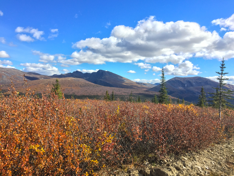
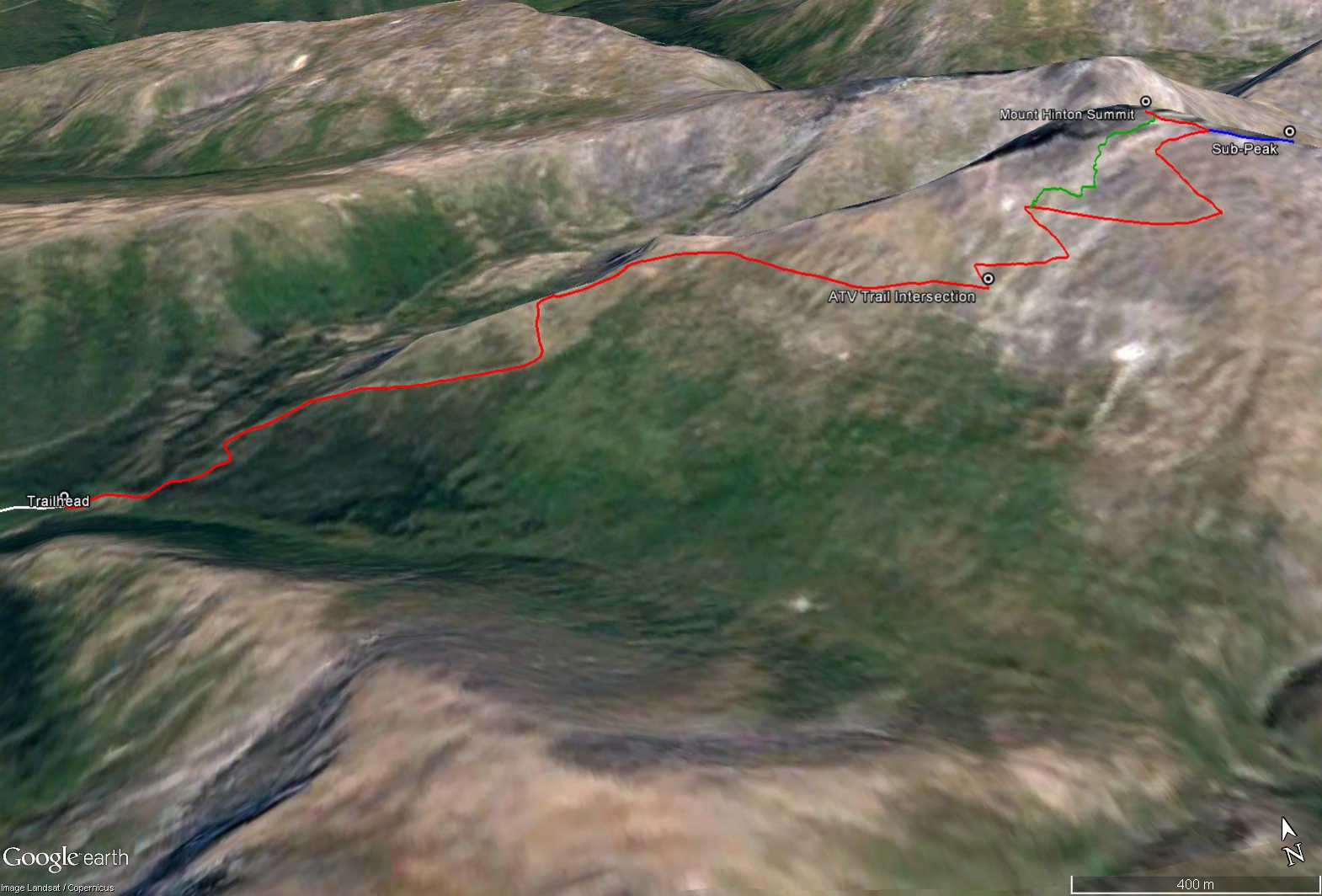
The views from Mount Hinton are some of the best in the Yukon, with rugged rocky mountains to the north and northeast and the rolling hills towards Mayo Lake to the south. The route is straightforward following along exploration roads nearly to the top of the mountain. Access to the hike is a long approach on the backroads from Keno City (10.7 km one way), requiring a 4x4 vehicle with decent clearance.
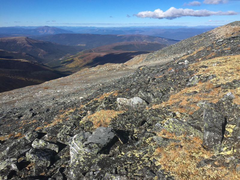
From the Keno City Campground, along Lightning Creek Road, cross the bridge over Lightning Creek and continue on the main public road, ignoring the first and second gated mining haul roads. The public road continues up the mountain (Sourdhough Hill). There are some rutted and loose gravel sections but most 4x4 vehicles with a little clearance should be able to make it up Sourdough Hill. After about 5.6 km you reach the highest point of the road on Sourdough Hill for some great views in the alpine (at about 1,445 m elevation). From there the road continues southeast and you begin to lose some elevation.
You will cross a small drainage at the bottom of a small valley at km 7.7. The road continues uphill again slightly and contours along another hillside. Keep following the main road which heads mostly east now. There is a major fork in the road as you approach the base of Mount Hinton at km 10, stay right. This other road appears to go up towards the lower north summit of Mount Hinton. Eventually the road drops down to the valley along a creek lined with shrubs. There is a small creek crossing (km 10.7) and then the road begins to climb steeply. This is a good place to park and start the hike (on either side of the small creek). You can continue to drive farther if you are comfortable driving your vehicle up very steep roads (as you'll have to be committed, there are not many places to turn around).
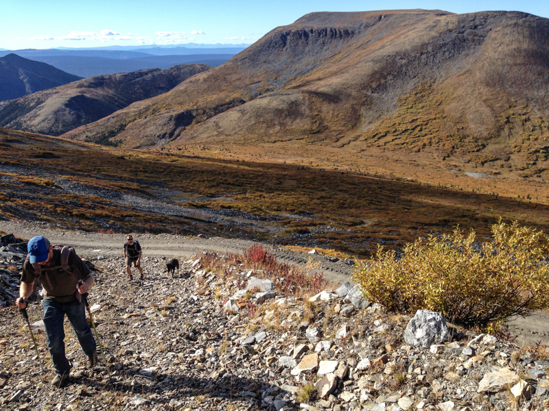
From the suggested parking area at the creek, follow the road as it climbs up hill. After about 1.5 km of hiking the road, you will reach the alpine. Keep following the road, which continues up a ridge to Mount Hinton and cuts across its slopes to the southeast. The road is surprisingly well maintained and very easy walking, with a slight reprieve in the elevation gain for a short while. Continue along the road until you reach a rougher, narrower, ATV-size trail leading up Mount Hinton to the left (km 3.2 of the hike). You could potentially have driven up to this point, if your vehicle and nerves could make it (cutting out 3.2 km of hiking). This ATV trail switch backs more steeply up the mountain, with looser rocks and is slightly overgrown in places.
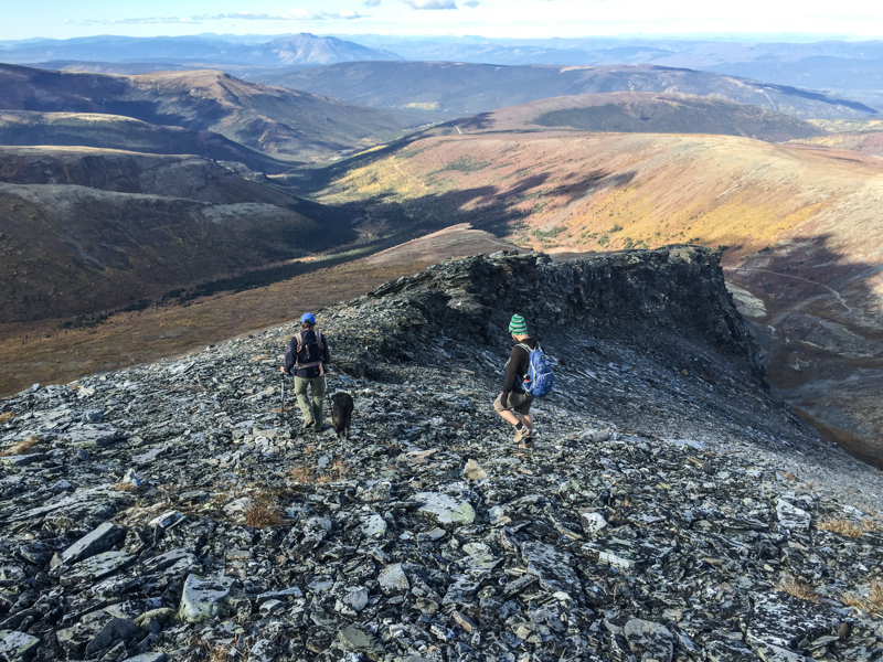
Follow this ATV trail for 1.6 km and over 300 m elevation up to a saddle between the main Mount Hinton summit and a smaller rocky sub-peak to the southeast. Note the ATV trail disappears near the top of the mountain at some mining exploration sites. From the saddle, the land gives way to a steep, rocky cliff face, with great views. You can also see Mayo Lake to the south. From the saddle you can take the option to check out the rocky sub-peak to the southeast, which is only an additional 0.25 km (one way).
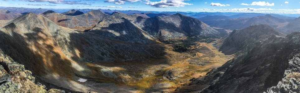
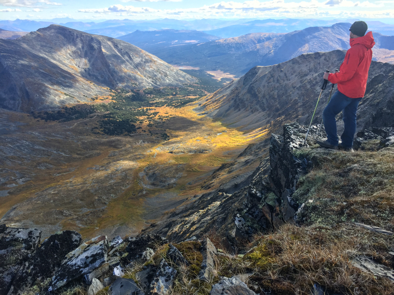
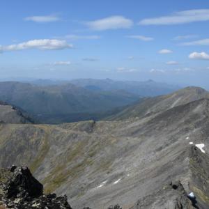
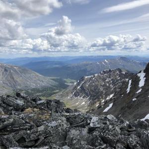
The main summit lies to the northwest and is a short hike across talus and moss. There is a rock cairn at the summit at an elevation of about 2,056 m. The views are stunning across the north to northeast, with rugged, rocky mountains and deep u-shaped valleys. The views in the other directions give way to rolling hills and lush forested valleys.
You can return the way you came up using the ATV trail, or also follow the southwest ridge down to meet the ATV trail at a lower point, cutting off almost half a kilometer. Note, the footing is looser on the ridge as you're not following any kind of trail/road, but it can offer a different perspective. It is easy walking down to the trailhead once you are back on the ATV trail and main access road.
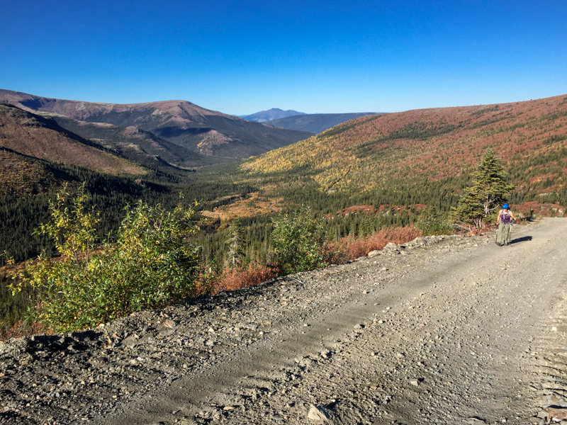
The distant view of Mount Hinton driving from Sourdough Hill.
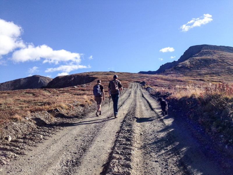
The start of the hike begins on a well-maintained road.
After about 1.5 km of walking the road you reach the alpine.
Leaving the main road and heading up the rougher ATV trail.
Towards the top the ATV trail ends at some mining exploration sites.
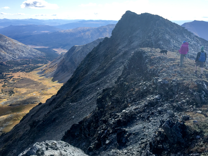
From the saddle the land gives way to a rocky cliff face and beautiful valley below. Here you can explore the sub-peak to the southeast with a short rocky scramble along the ridge.
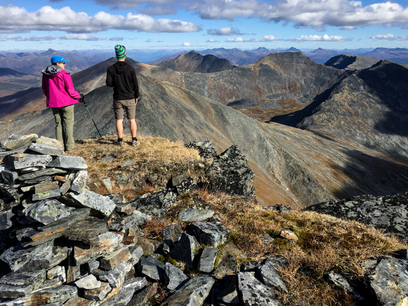
From the main summit the views to the north and northeast show rocky peaks as far as the eye can see.
Enjoying the views perched high on the ridge.
On the way down you can shave off a bit of time if you like, and head down the looser rock of the soutwest ridge to meet up with the ATV trail.
Sarah July 27, 2026
The sourdough trail road is now washed out. You will need to take the upper duncan creek road
Sire Quentin du Quintal August 4, 2020
You will deinitely need a 4x4 to go to the trailhead. Apart from that... The trail is not really challenging as you mainly follow prospection trails. But... views are really beautiful from the top. Plus... you are in Keno. So... get drunk at the sourdough tavern and hike as high as you can!
Ryan w June 22, 2019
Great hike. I misunderstood the driving directions and parked at a small creek about 3 km from the actual creek but the extra distance was fine. Bear tracks and scat along the road, be bear aware always.
Benjamin H August 28, 2018
Hiked this on Sunday August 25. A great hike! I will second what Kate says below about looking for the switchback trail as you are approaching. If you do go past, you will eventually end up at a Y in the road where the left fork becomes a trail. This trail basically goes in a straight line up to the ridge. You will be at the saddle between Hinton and the peak to the south east. Walking along the ridge is quite nice.
As for the road in, I drove my 93 Toyota corolla 4wd up to almost the creek crossing. There had been a lot of rain all summer but the road although rutted and rocky is not bad. The surface condition of the road actually improves considerably once it gets steep and the corolla most likely would have been just fine. But as the description says, it is indeed very steep in places and i would not go without a 4wd.
As a side note, the drive up to signpost in Keno is well worth it with plenty of opportunity for exploration by foot and the views although not as expansive, are still awesome.
Kate August 20, 2018
This was such a lovely hike. The promised view was absolutely stunning. Mountains for miles. (And as a side note, Keno itself is also everything I hoped it would be! Such a ridiculous, neat town.)
The trail description was accurate and we had no trouble with it. We parked at the suggested spot, but our vehicle (Jeep Grand Cherokee) would have had no trouble making it up the road to the ATV trail. The only issue would have been parking. The road is a bit narrow and leads to an active placer claim - we passed multiple big trucks on the walk in and in most places, wouldn't have been able to park somewhere that wouldn't block the road.
I recommend trying to spot the ATV switchbacks as you hike up the road - you can see them when you are quite a ways off and it makes it easier to find the ATV trail when you get a little closer. The trail is indeed on your left, but it immediately switchbacks back the way that you came, so you have to look to the left and a little behind you to spot it easily.
We were so happy we made the trip in for this one. It is a really great corner of the Yukon. In a week or two, I bet the colours in the area are going to be so stunning!
Bob G. November 13, 2017
Was there in June, camped at keno campgrounds, trail was great, very senic and lots of old mining sites. Loved the museum in Keno, the few people we met were great, very friendly
