Total Distance: 17 km
Return Time: 2-4 hours
Elevation Gain: 596 m
Difficulty: Moderate
Region: Whitehorse
Traditional Territory: KDFN
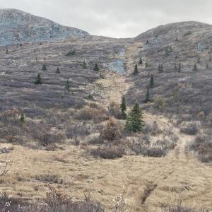
Named after the creek that flows below the ridge, Jackson Ridge (not an official name) is an easy hike close to Whitehorse. There is no real bushwhacking and the ridge has panoramic views from the Fish Lake area to the Ibex Valley. There are also some impressive rocky ledges and cliffs on the other side of the ridge (SW side). A mountain bike is a great way to shave off 2.5 km of the hike (each way), as the first section is on mostly flat dirt road. The hike is about 2 hours with a bike, and up to 4 hours by simply hiking the whole route.
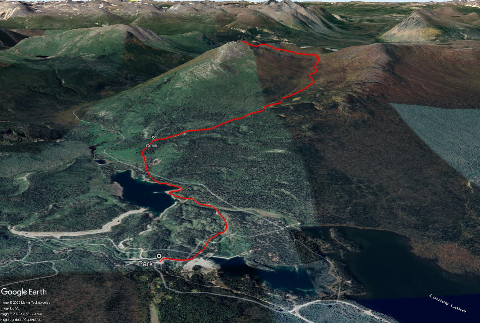
Drive down the Fish Lake road for 9.7 km and turn right on the Jackson Lake Road. You'll reach a fork in the road after 3 km - stay straight / left. You'll reach another fork in the road after 400 m, stay left again, driving uphill. At the top of the hill (400 m), pull over and park near the small footbridge.
Cross the bridge and look to your right for a rough ATV trail through the forest. It may be hard to see the entrance to the path, but once you find it, the path is wide and easy to follow.
After 500 m, you will meet up with the main road that leads to Franklin Lake. Turn left and follow this road along the side of Franklin Lake. You will eventually come to a creek (2.5 km from where you parked). Don't cross it, but rather take the road on your right, just before the creek. If you decided to bike, this is a good place to stash your bikes. It isn't recommended to push your bike up this rougher road, as the road is steep with loose rock, and you may end up doing more pushing than riding.
Walk up the rocky road, as it eventually leads into the sub-alpine. Jackson Ridge will appear on your left. Continue following the road for 4.4 km from the creek until you are at the far end of the ridge, and the road takes a sharp left turn.
Leave the road at this point, and head towards the ridge through the sub-alpine vegetation. You should be able to piece together openings through the vegetation without having to bushwhack. Soon you will be out of the bushes and in the alpine. Once at the base of the ridge, you can choose your route up to the top of the ridge. Avoiding the rocks and staying on the alpine vegetation is the easiest route up.
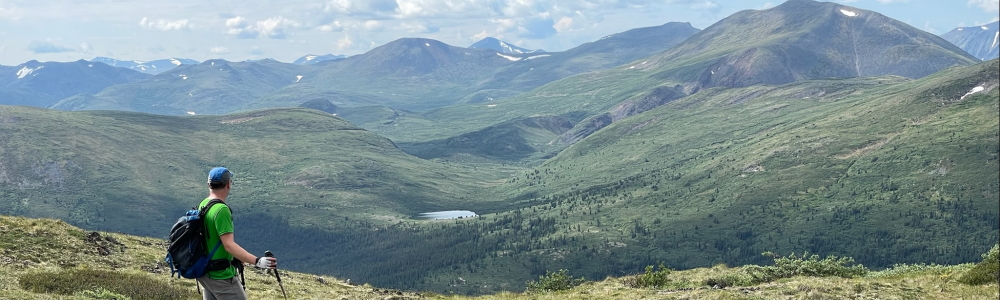
Once on the ridge, take in the views of the Ibex Valley to the northwest and Fish Lake and Bonneville Lake area to the southeast. You can hike back along the ridge a bit and check out the rocky ledges and cliffs on the other side. Return by the same route.
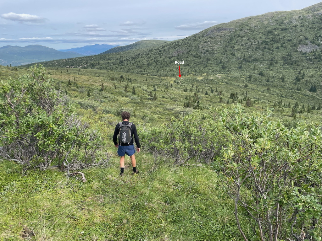
Hiking back down from the ridge, this shows the sharp left turn in the road in the distance.
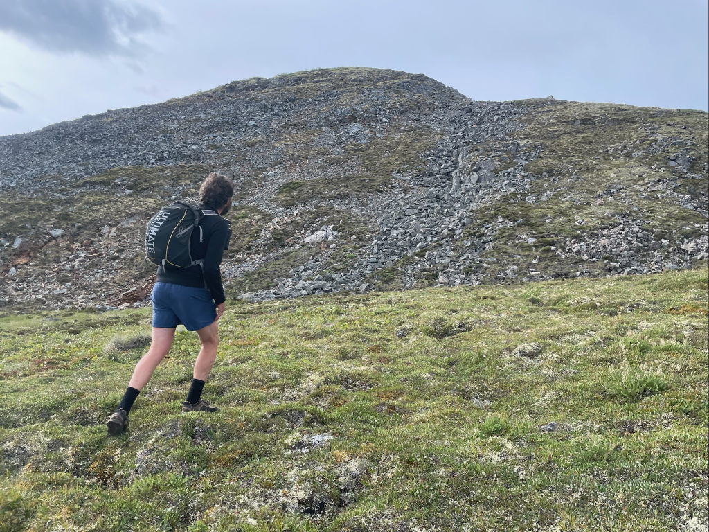
Looking up Jackson Ridge. Pick a route around the rocks to the top.
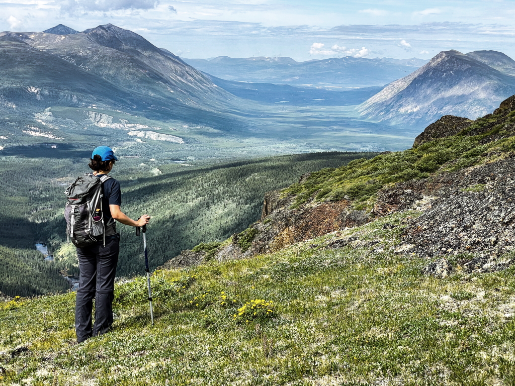
From the top of the ridge, looking towards the Ibex Valley.
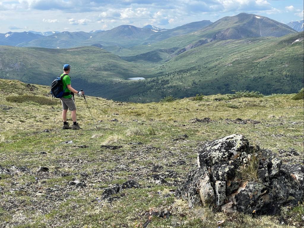
Looking back towards the mountains above Bonneville Lakes.
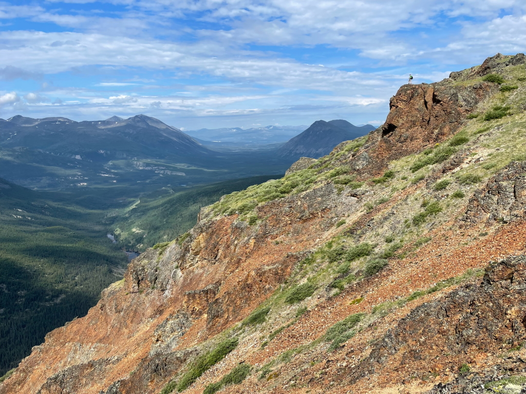
The rocky cliffs on the west side of the ridge.
Shailyn June 12, 2026
Hiked with a friend on June 7th - my first time on this trail.
The time given for this hike is definitely not for your average hiker. I am relatively fit and it was still a six hour hike (not the 2-4 that the description says). There was still snow to navigate through up high, but it was doable. We stuck to the lower ridge as the snow on the main ridge would have been too sketchy in the snow. Such great views of the Ibex Valley. And now I am confused because I have run down "Jackson Ridge" twice during the Raven 50 race, except it was not this ridge, it was the one on the other side of the ATV trail that is connected to Sumanik ridge. Who knows! No signs of wildlife, just lots of butterflies and mozzies/black flies.
Bonnie May 6, 2025
Hiked on March 30th and the trail was fabulous. We packed our snowshoes all the way and were fine in just hiking boots.
Jay July 14, 2024
Did this hike Saturday — three men on a side-by-side pulled up to us while we were in the subalpine and said they had seen two young male grizzlies fighting and running along a section of the trail we'd already passed. Our group didn't see the bears at all on our way up or down, but the men were very concerned for us — they said they had wanted to turn around, but saw our footprints going up the trail and decided to drive up to warn us. They also waited on the side of the trail until we returned. Of course the Yukon is best country but I'd recommend exercising extra caution if you're planning on doing this hike anytime soon.
Steph June 19, 2024
Just to comment on hiking time: without bikes, we took about 4h at fairly fast speed (without breaks).
Susan August 11, 2023
Thank you for this website. We did 2 of the hikes mentioned here in Tombstone and then this hike. The time estimate on this hike, however, we found to be completely off. We rode bikes to the creek amd back, as stated, but this took us over 4 hours round trip with bikes. I looked at the overall distance amd even with bikes taking off 5 km combined, it seemed like a stretch to complete 17 km in 2 hours. And it certainly was. We also ended up bushwhacking up to the ridge from the road. There were flag markers for a bit but then stopped or were lost to me. Really fun to combine our mtn bikes on this and I loved the adventure of doing than, but unless you know the route intimately and are running the hiking portion I don’t see how this can be completed in 2 hours.
Pippa Lawson October 4, 2022
By walking a couple hundred metres further along the road (past the flagged turnoff point), you can avoid bushwhacking and rocks - there’s a wide open grassy route (old ATV track) that leads right up to the ridge, albeit further north. Easy walking!
Alex F August 28, 2022
Biked and then hiked as described here. It was great with beautiful views.
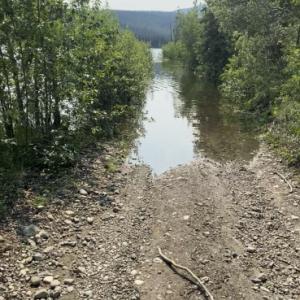
No problem with flooding when we went.
Yukon Hiking July 21, 2022
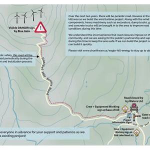
Notice regarding construction on the Haeckel Hill Access Road affecting the FISH LAKE ROAD (and therefore potentially access to hikes like Fish Lake & Jackson Ridge ):
INFO FROM Eagle Hill Energy Limited Partnership:
Over the next two years, there will be periodic road closures in the Haeckel Hill area as we build the wind turbine project. Along with the wind turbine components, heavy machinery such as excavators, dump trucks, graders, and concrete trucks will be brought into the area to improve road conditions during this time. We understand the inconvenience that road closures may impose on the local community, and we are asking for the public’s partnership and support during this time to keep the area safe.
Check out the website for regular updates before you head out: https://www.chuniikwan.ca/eagle-hill-energy
Kat July 18, 2022
We tried walking through the overflowed lake, but found it to be between thigh and waist deep for several hundred meters, and our bikes were floating. We found a few lesser used roads to connect on the non lake side that enabled us to get around the lake ok.
YUKON HIKING July 12, 2022
Laura thank you for the update! Water levels in the area are controlled by ATCO Electric as part of the larger Fish Lake Hydro system, which affects water levels in Louise Lake/Jackson Lake and Franklin Lake. This may result in water levels in Franklin Lake rising over the road at times.
Laura July 4, 2022
You may need some triathlon skills for this hike! Tried to hike it today, biked about a km down the road before the lake had taken it over.