
Total Distance: 5 km
Return Time: 1.5-2 hours
Elevation Gain: 345 m
Difficulty: Easy
Region: Atlin
Traditional Territory: TRTFN
*** Distance and Time is one way***
Burdette Creek is a beautiful destination in the summer and winter just south of Atlin. The main attraction besides the great access to the alpine is the Burdette Cabin, a beautifully crafted backcountry hut that can be reserved through the Atlin Alpine Society. There are separate routes for each season, with trails built and maintained by the Atlin Alpine Society. From the hut, you can hike Sentinel Mountain and its extensive ridges with sweeping views over Atlin Lake and the surrounding valleys.
Directions are different for the summer and winter access, as the trailheads are in different locations and utilize different routes.
Coming into Atlin on Highway 7, at the T-junction turn left onto Surprise Lake Road (right goes to Atlin on Discovery Ave). After 130 m you will take a right on Warm Bay Road. You will drive the Warm Bay Road for 26 km to the very end. You'll pass various recreation sites, including the Palmer Lake Rec Site, Warm Bay Rec Site, and finally the Grotto Recreation Site. Here the Mud Bay Road ends, and the less maintained O'Donnel River Road begins. There is a large parking area here. See Winter or Summer access below.
WINTER ACCESS
For the winter route, you will park just after the Grotto Recreation Site (make sure to leave enough room for other vehicles and trailers). Ideally you will have a snowmobile to reach the trailhead via the O'Donnel River Forestry Road. Otherwise, it adds a much longer walk or ski approach (12 km). Or there is the option to hire someone to snowmobile you in (the Atlin Alpine Society can share contacts for this).
Follow the O'Donnel River Road for 8 km. At this point the road drops down to a creek crossing over Burdette Creek. The creek can be open sometimes in the winter/spring depending on weather. The road is wide and usually well packed by snowmobiles to this point. There is also a small bridge upstream which can be used to cross.
After crossing the creek, head left at the next intersection. The trail becomes more up and down and windier as you traverse above and beside Burdette Creek. After 4 km on this side road, you will reach the start of the non-motorized zone, where the actual trailhead starts. There are signs to mark this zone and ample parking to turn the snowmobile(s) around and park.
SUMMER ACCESS
For the summer access, you can drive or bike the O'Donnel River Road. The trailhead is 14 km from the end of the Mud Bay Road. There are quite a few potholes and wet sections along the road, so it is slower going and best suited for a truck or SUV.
After 8 km from where the Mud Bay Road ends, you will drop down to the Burdette Creek crossing. Note there is a foot bridge over Burdette Creek on the upstream side (left). Once you cross the creek, you will keep right at the fork and continue on the road for another 2 km until another fork. At this fork, turn left and drive another 4 km to reach the trailhead. There is parking and a trailhead sign at the start.
This route is mainly for accessing the Burdette Cabin run by the Atlin Alpine Society. If you do not have the cabin booked, you are better off doing the Eldorado - Sentinel Hike which is just on the other side of the ridge from Burdette. You can access a lot of the same hiking and skiing terrain from the Eldorado Creek Valley.
The cabin must be booked online ahead of time and fills up fast in the winter and summer. See more details on the Atlin Alpine Society website.
ABOUT THE CABIN
If you booked the cabin you are in for a treat! It is beautifully built with local logs and timber frame craftsmanship. It is well equipped with dishes, utensils, cooking pots and pans, coffee press, and even a fondue pot with fuel! The cabin has a gas stove for heat, a propane cooktop for cooking and a sink to do dishes. All the fuel is included in the price. It is well stocked with games and books as well as binoculars to look for mountain goats and other animals. The upstairs loft is for sleeping. The max capacity is 6 people. There is an outhouse and electric fence to keep bears and porcupines out. It also has a deck and camp chairs for relaxing in the sun.
SUMMER ROUTE (one-way) 345 m elevation, 5.4 km, 2 hours
From the trailhead follow the marked trail that heads into the forest to the northwest. The elevation gain is gradual as you hike through the forest, interspersed with meadows. After about 2 km you reach the sub-alpine and the views open up as the trail heads between two smaller mountains. Shortly after that the route heads west (left) along a little gully. Then the route continues northwest again, across a meadow and then contours along a mountain side on your right. Here the trail alternates between talus rock and a dirt trail through the sub-alpine forest. The wildflowers are gorgeous in July and early-August.
Eventually the route will start heading down to the Burdette Valley. The trail takes you to the Burdette Cabin, after crossing a small creek gully. Extended hiking options are shown below.
EXTENDED OPTIONS
There is lots to explore in the summer, though more bush and trees to contend with compared to the winter, as you're still in the sub-alpine at the cabin.
To reach the ridges to the north and Sentinel Mountain to the northeast, it's best to access the ridge directly northwest of the cabin. Head west from the cabin along the creek for about 250 m looking to the north for some open areas in the trees and bushes. You can pick your way up this slope, through trees and sub-alpine shrubs, generally heading west until you reach the open alpine ridge. From here it's easy to pick your own route up to the ridge, and there are some neat rocky outcrops along the way to check out. Note it does get quite steep and rocky near the end.
Overall expect about 536 m elevation gain and 2.4 km of hiking to gain the ridge. From the ridge you can get amazing views of Atlin Lake to the west and southwest, as well as down into the Eldorado Creek Valley, to the north. This is a great spot to turn around or you can hike the ridge either along to the right to Sentinel Mountain or to the left for more views and fun ridge walking.
To reach the summit of Sentinel Mountain (1,920 m), follow the ridge to the east for 2.1 km and another 198 m elevation gain. It does become quite exposed towards the end along a narrow ridge and there's some light scrambling to reach the peak.
(one-way) 185 m elevation gain, 3.3 km, 1.5 hours
The winter route is slightly shorter than the summer route with less elevation gain.
From the snowmobile parking, the route heads northwest up through the forest. It is fairly gradual elevation gain along the route, until you reach the alpine after about 1.7 km. It is best suited to alpine touring skis or splitboards but can also be done in snowshoes.
Since the cabin is well used it should be well-packed between users coming and going. Though once in the alpine where it is more exposed, any tracks can get covered by windy conditions and/or fresh snow, so make sure to bring the GPS track to reach the cabin.
Once in the alpine you head generally north - northeast across a flatter open plateau. Nearing the cabin, the route drops down to the creek and then heads right (east) to the cabin.
The cabin is the perfect base for more exploration, from great treed skiing just around the hut to larger more complex objectives.
EXTENDED OPTIONS
There are many slopes to choose from around the cabin to get some good ski and snowboard turns. With different aspects to choose from you can select different routes depending on the snow and wind conditions and avalanche risk.
Note there is no avalanche forecast for the area, but you can search mountain weather forecasts for the Atlin area and review any entries in the cabin guestbook for updates on conditions.

The first part of the summer trail goes through conifer forest.

The forest opens up into several open meadows.

Once in the alpine follow the footpath and watch for trail marker signs (posts with yellow markers).

Closer to the cabin, the trail traverses some talus slopes.

The trail alternates between talus slopes and beautiful wildflower meadows.

Near the end of the route, the trail descends down to the cabin (visible in the left background).

View from one of the cabin windows.

To access the extended hiking options, you can hike up the open meadows to the northwest of the cabin to access the ridge above.

Exploring the rocky outcrops on the way to the ridge.

Views looking south and east from the ridge.

Once on the ridge you can see beautiful views of Atlin Lake to the southwest as well as the Llewelyn Glacier.

Exploring the ridge to the east with Sentinel Peak in the background.

Peering down to a small lake in the Eldorado Valley to the north.

Hiking back to the cabin after a day of exploring the ridge.

Skiing into the cabin nestled in the snow.

The main floor of the cabin has all you could want and need for your stay.

The loft of the cabin upstairs has room for 6 to sleep.

The moonlit cabin.
There is a lot of great terrain to ski. Here a skier skins up the ridge to the east.

You can find gentle tree skiing just behind the cabin.

A longer objective is to ski the valley directly west from the cabin to reach a larger open ridge system.

Powder turns on the slopes to the west.

Enjoying the sunny deck after a great ski.

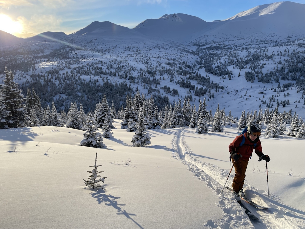
Following the skin track out to the snowmobile parking.

Sharina June 15, 2025
We had a very smoky, rainy and foggy hike to the cabin yesterday. Minor snow patches on the steep slope down to the cabin at the very end but nothing to worry about!
Saw some relatively fresh bear scat near the beginning of the trail and moose tracks following most of the trail but no other animal sign.

