Total Distance: 11 km
Return Time: 6.5 hours
Elevation Gain: 901 m
Difficulty: Difficult
Region: Carcross
Traditional Territory: CTFN
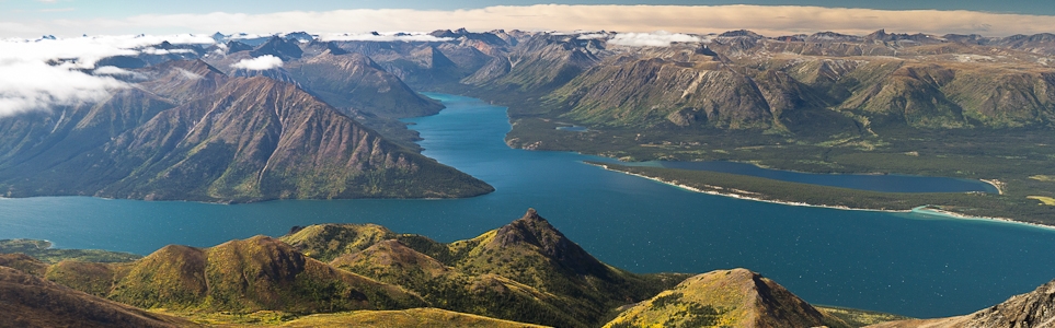
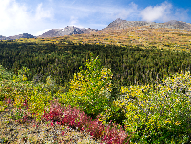
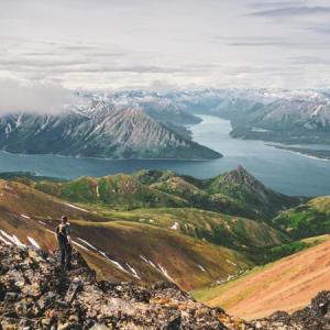
Brute Mountain is an exciting and challenging hike up to a rocky peak with sweeping views over Bennett Lake, Montana Mountain and Carcross.
This is the same trailhead as for Montana Mountain. From Carcross, drive south on the South Klondike Highway across the bridge and take your first right. Take the next left up a gravel road. Continue straight up, you’re on the Montana Mountain Road. The condition of the road varies depending on recent maintenance work and road use. Note the area has a big mountain biking trail network so make sure to share the road.
Drive for about 8 km on the Montana Mountain Road. There is a smaller washout around here that you may or may not be able to drive across. At KM 10, there is a landslide that is impassable by vehicle, and this will be considered the trailhead.
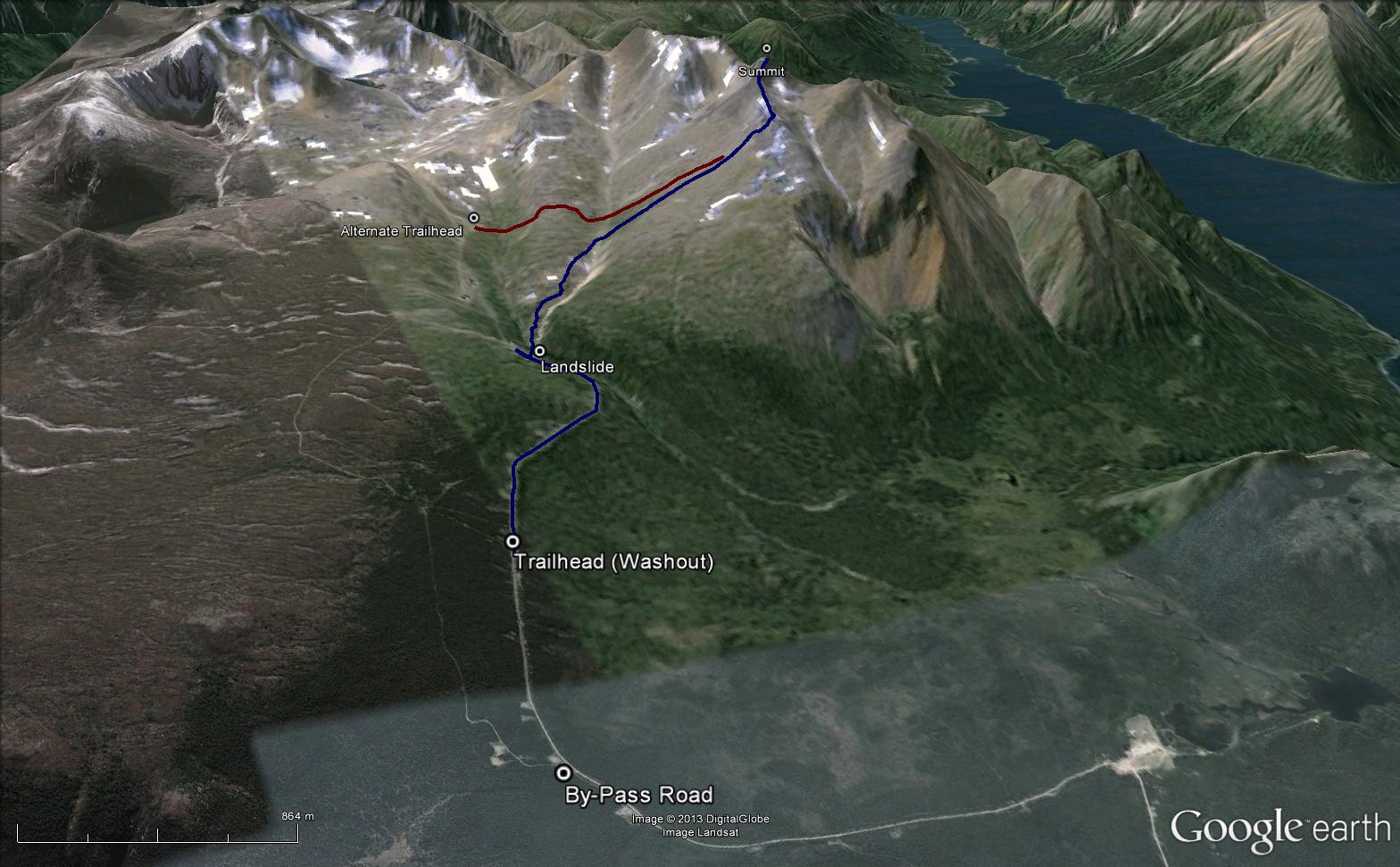
From the trailhead (the washout), follow the road until you reach the landslide area. There are actually three parts to the landslide; the first two parts are small slides which have a pretty worn trail across them, the third slide is the largest and there is little to no trail across it. But luckily for you, for this route there is no need to cross the last slide, as you will instead need to drop down to the creek below.
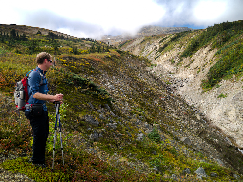
Cross the creek and follow it upstream for about 20 meters until you reach a fork of two creeks. Take the right fork, following up high on the left bank of the creek. This is a nice portion of the trail as you hike gradually uphill above the creek and its rocky canyon. Eventually the slope you are following will reach the same elevation as the creek - this is good place to cross and head up the slope now to the west aiming for the right portion of the ridge of Brute Mountain (north ridge). The terrain is a mix of low growing shrubs and lichen, and large rocks.
Once on top of the ridge it becomes all rocks. The route is straightforward from here as you follow the rocky ridge to the summit, however there is some pretty serious scrambling as the ridge becomes a jumble of large rocks and slippery lichen. Once you reach the peak it will be worth it with stunning views over Bennett Lake to the west and the Montana Mountain area to the southeast.
Follow the same route back, or come out higher on the road to avoid climbing back up the landslide area. This is a less direct way and can add another kilometre.
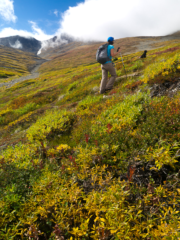
The view of Brute Mountain while hiking up the Montana Mountain Road.
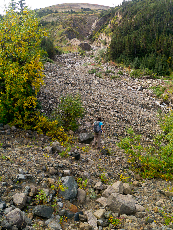
Dropping down to the creek from the landslide area.
Follow along the left side of the creek.
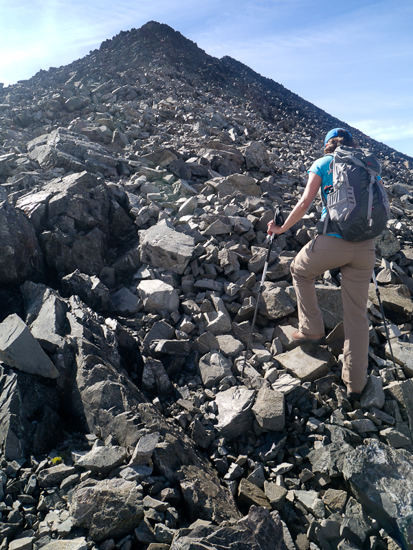
After crossing the creek, head up the slope to the west aiming for the right/north end of the ridge of Brute Mountain.
Once on top of the ridge, follow the rocky slope to the summit.
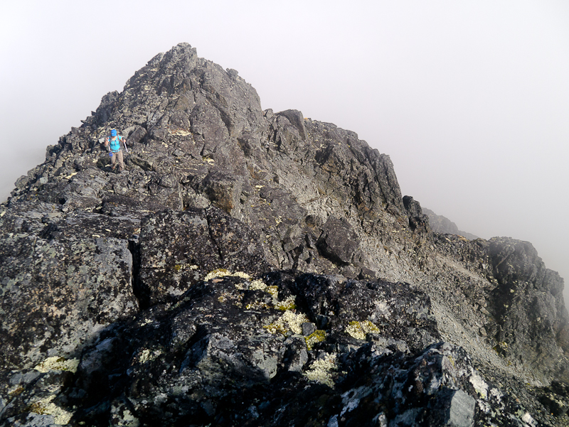
Towards the summit, you'll enjoy quite the scramble as you make your up through the jumble of rocks.
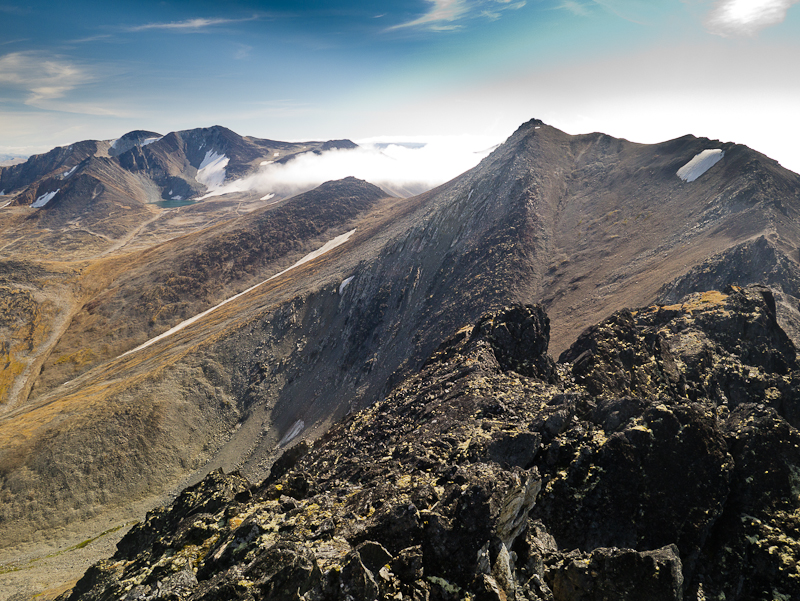
View of Montana Mountain from the summit.
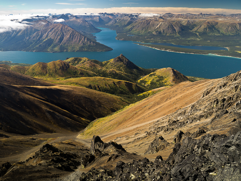
The view over Bennett Lake, with the start of fall colours.
Yukon Hiking September 16, 2025
CLOSURE NOTICE Alpine Trail Access Closed Due to Bear Incident
Please be advised that there has been a bear incident on MONTANA MOUNTAIN, and there is reason to believe the bear may be injured.
C/TFN has requested that users avoid all trails accessing the alpine until Guardians and Conservation Officers can assess the situation. In the interests of public safety, the following trails/routes are TEMPORARILY CLOSED:
• Access to the Mountain Hero Trail
• The Mountain Hero Trail itself
• The Brute Mountain and Sam McGee routes (as described in Yukon Hiking)
We also ask all trail users to exercise extreme caution on all other trails and to follow these important safety tips:
• Keep pets leashed at all times
• Carry bear spray and know how to use it
• Travel in groups and make noise
• Report any further sightings to Carcross RCMP
Keith C July 27, 2024
I hiked Brute Mountain today, July 27, 2024. My opinion only: this is a tougher hike than Mt. Lorne or the Tors or Kings Throne. Throughout, you have to cross a creek, there is no well-established path or markers and may require you to wade through low brush, and the ascent from the base of Brute is demonically tough. It is all loose jagged and sharp rock, large and small. Come prepared.
I found that going through the wash-out/landslide area towards the cabins (the alternate route in red in the above picture) was easier than dropping into the creek. During the ascent, I dropped down to the creek. On return, I took the alternate route. The creek water levels could be higher when it recently rained, making traversing it (and staying dry) harder. You'd still need to cross the creek (two crossings, in fact) in the alternate route but the creek gets much easier to manage higher up. Bring bug spray! Sources of water = lots of bugs, esp. mosquitos. If you do Brute too early (May, June), there may still be lots of snow. It's end of July and there are large patches of snow in the crevices/valley--but don't worry--they won't pose an issue, easy to avoid them. No snow in the summit.
Poles are a mighty help, and so are gloves for scrambling. From the base of Brute, the summit looks near but don't be fooled--scrambling and ascending safely takes time. When I descended the summit, I didnt go down along the ridge, but instead, immediately dropped down on the side that looks towards Montana Mountain. It was all loose rock and immediately made meat crayons of my hands. Don't go down that way.
When you get to the summit: what a spectacular 360 view--made the hike worth it! No wonder the cover of the Yukon Hiking book was taken from this mountain!
Anthony August 28, 2023
I followed the mining roads all the way up the base of Brute. From there it was only 2 km direct line to the summit, although slightly longer I think this is a better route than hiking up the drainage. I'm not a confident scrambler but I had no issues getting through the final section up to the summit.
I had thought about trying to follow the ridge to the southern peak but it has some gnarly stuff. Instead it was easy enough to drop down a few hundred meters, traverse across and climb back up. The south peak is easier to get to and is actually slightly higher elevation than the named summit.
Liz B June 24, 2023
We hiked Brute in a group of two on June 24. We parked just before the washout, we probably could have made it over the washout and to the landslide with our xterra but opted to walk the extra distance.
We headed down to the creek at the landslide and followed the creek up to the plateau area, where we saw a big group of mountain goats with four kids.
Hiking is fairly easy going until you get to the ridge. The bottom of the ridge is a lot of loose unstable rocks and the ridge turns into a decent scramble the closer you get to the summit. Hiking poles were extremely helpful for the ridge section. There were a lot of snow patches on the ridge; we were able to skirt around most of them and only had to walk across three patches (very short crossings, 10 meters max through the snow). Snow patches along the ridge, closer to the summit, made for some pretty nerve wracking detours but as long as you're comfortable with heights it's no problem.
Views at the summit are unreal! We've hiked Nares, Caribou, Montana and Mt. Grey, and the Brute views are my favorute (although all are stunning).
On the way back down, we followed the exploration road that goes past the old mining buildings and meets up with the road above the landslide. I think this way was easier following our original route, which would have meant scrambling back up the landslide area.
In total, our distance was 15.16kms with an elevation gain of 1082m. We ended up doing four creek crossings (two on the way up and two on the way down) with no difficulty. We started the hike at 8am and had the mountain completely to ourselves.
cougar August 23, 2021
Attempted thev trail today after going to the higher Caribou Mountain peak in the morning and spending some time in Carcross at lunchtime. Dont have a 4Ă—4 so I started hiking from the parking at around 900m elevation and 4.3 km before the washout trailhead. Turns out you can follow the road over the third slide and continue to the cabins and arroud. Made it to the base of the peak at elevation 1,800 but it was 6pm and I had to turn back. Reached Whitehorse dead tired at 9pm only to find out Airport Chalet had inexplicably cancelled my reservation! The hike is very nice ofering awesome viwes - even if you do not reach the top like me. The roads offer an extra level of comfort, you cant get lost on a clear day. The old cabins had new inhabitants - at least 2 foxes. Please keep this in mind and give them room.
Braden May 24, 2018
Attempted this trail on May 21, 2018 but with no luck. Once you get close to the landslide the remaining unmelted snow makes it nearly impossible to climb any lower towards the creek. For safety we decided to head up sugarloaf instead to maybe get a veiw of montana mountain but got pushed back to the truck by the insane amount of wind, snow, hail and rain. Couple more weeks of sunshine and it will be ready! Still a bit early this year for the amount of snow we got but even the veiws up sugarloaf were breathtaking. Cant wait to come back for more!
Marc June 25, 2016
Did this June 23rd and parked at the 8 km point where the first washout is. I started around 4 pm and it took me 6 hours round trip. This was my 4th attempt on Brute Mountain. I had previously tried twice in September 2015, and once earlier in June this year. All three times, the summit was foggy, cloudy, extremely windy, over a meter of snow on the ridge and very cold.
Finally, when I was starting to think it was impossible, I got to see Brute Mountain on a clear, wind free and sunny day!! Beautiful hike and very fun in these conditions. Almost no snow left. I highly recommend taking the alternate route proposed on here (blue in the photo). Just keep following the road after the landslide at km 10 and you'll get to the 2 small cabins down below. They are easy to spot. Hiking from there is way easier. Even though it adds one kilometer to your ascent, you'll eventually save time.
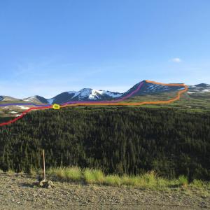
If you decide to drop down to the creek below (red in the photo), just be prepared for it. You'll be following the creek from above (to the left of the creek) if this is the route you take. From where the 2 trails meet and where you cross the creek again to get to the ridge of the mountain (yellow circle in the photo), you also have two options. You can go all around the ridge like described here (orange in the photo) or make your way directly up (purple in the photo). Note that there is no more obvious trail to follow after you cross the creek. Also note that the summit you see in this photo is a false summit. This is 1 of 3 summits (the 3rd having the best view and is just slightly further).
I found taking the alternate route (blue line) and going straight up (purple line) was the quickest and easiest way to do it. Very cool hike. Great views of Montana Mountain, Carcross area and Bennett Lake.
Marc B July 19, 2014
On the 18th of July, made the summit and back in 8 hours along with two boys respectively 6 and 7 years old. It was a gorgeous day that started totally fogged in with two creek crossings and sliding down snow patches on the way back. The top scrambling was very much appreciated by the little ones and we stopped just short of the actual peak as maybe the very last bit was a little too exposed for young people. Highly recommended alpine meadows, flowers and rocky peaks punctuated with splendid views from the top.
Note : We drove past the washout area through the bypass road but the section above the treeline was an actual running creek with much eroded banks and center areas at places. Had to bypass by going through the brushes and grateful my 4x4 high clearance vehicule was able to handle. Would not recommend unless familiar with serious 4x4 offroading. We parked where bypass road rejoins the main road, passed the washout.
