Total Distance: 24 km
Return Time: 2-3 days
Elevation Gain: 1017 m
Difficulty: Moderate
Region: Kluane
Traditional Territory: KFN, WRFN
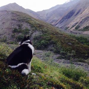
Bock's Lake is tucked amongst beautiful mountains and moraines. The route up the creek is straightforward but can be tricky depending on the water levels. It is long as a day hike so camping at the lake is recommended, plus there are many side trips from the lake with incredible views.
Drive 100 km north of Haines Junction on the Alaska Highway. About 14 km north of the Congdon Creek Campground you will see a highway sign for Bock's Creek, as well as a wide creek bed. You can pull off the highway onto a road, just after the creek on the north side. This is an active mining road, so leave room for vehicles to get past. You can drive up this road to cut off a few kilometres if you want.
Note: This hike is within the Kluane Wildlife Sanctuary and not in the National Park & Reserve, unless you do the Bock's Lake to Congdon Creek connector via the Duke River.
It is a 12 km hike (one way) up to Bock's Lake and it takes about 6 hours. It is recommended that you camp at the lake and perhaps even spend one extra day in the area for a day hike. If you only have 1 night, you could hike one of the side trips the evening you arrive at camp, or in the morning before hiking back out. Regardless, make sure you take one of the side trips above Bock's Lake. It's definitely worth it.
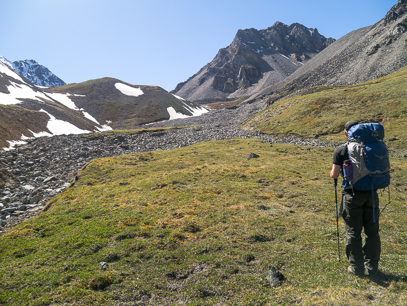
Start by following the mining road along the north side of Bock's Creek. The road may disappear shortly up the creek, as it frequently gets washed out from year to year and is only sometimes rebuilt.
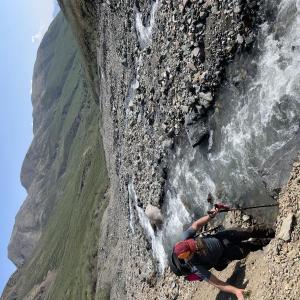
If water levels in the creek are low, you can just pick your way up the creek bed. You may or may not have to take off your hiking boots to cross the creek when necessary. If water levels are higher, you may have to cross the creek a few times, so creek crossing shoes are recommended.
The route is straightforward in the beginning - just hike up the creek bed. On your left at roughly 6.5 km is a pass that leads to Nines Creek. If you are hiking to Bock's Lake, ignore the pass and continue hiking up the creek bed.
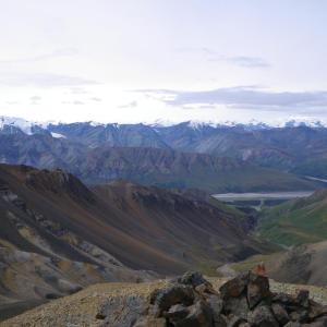
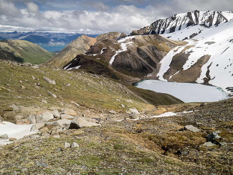
After roughly 10 km, the creek route looks like it starts to split. You want to follow the creek to your right. The route starts to climb and gets narrow at this point. You will eventually reach some islands of vegetation - welcome relief after having to walk on rocks for the past few hours. Keep following the creek bed until you reach a vegetated hillside on your left. On the other side of the hill is Bock's Lake, so you can climb over it at any point now, although it is best to wait until it is a bit more gentle sloping. From the top of the hill, or just a little further, you should see Bock's Lake below you, tucked up against the mountainside.
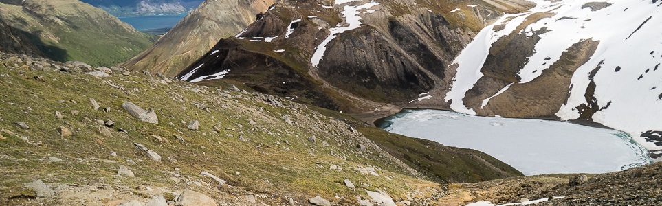
If water levels are low (or the lake is partially frozen, which it can be, even in July), you might be able to find a flat spot to camp down by the lake. If not, find a suitable spot on the hill next to the lake.
EXTENDED HIKE OPTIONS
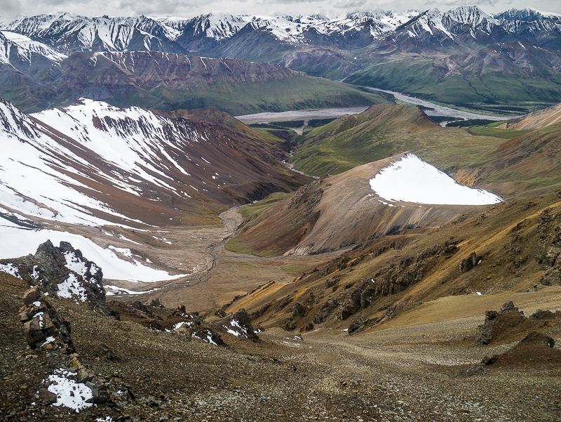
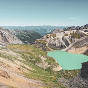
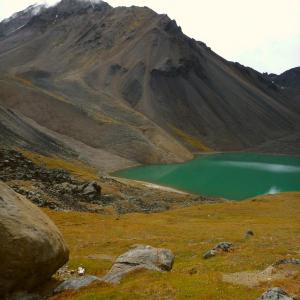
There are two recommended side trips that you can hike from Bock's Lake. The first one is the mountain pass between Bock's Lake and the Duke River. It is about a 5 km return trip from Bock's Lake and gets to an elevation of 2,170 m. You can see the pass when looking south across Bock's Lake. Start by getting around the lake (left side if water levels are low, right side if they are high). Hike along the bottom of the moraine until you are forced to start climbing upwards. Once you are up on the moraine top, stay high on the moraine that leads towards the pass. At the end of the moraine, you will have one last steeper section to go up to reach the pass. The view from the pass is spectacular, and you can see the route down to the Duke River. The creek flowing down and the alpine meadows below look primeval.
The other recommended side trip is to the west of Bock's Lake, up to a saddle that has a sweeping view of the Duke River and deep into the Kluane Icefields. It is about a 6 km return trip from Bock's Lake and gets to an elevation of 2,348 m. Hike west from the lake, and try to get up on the vegetated areas as they are easier to walk on than the rocky moraines. Climb up the hills and then aim for the base of the ridge in front of you that angles up towards the mountain on your left. You can hike this ridge to the top of the saddle. There is a small snowfield on the other side of the ridge.
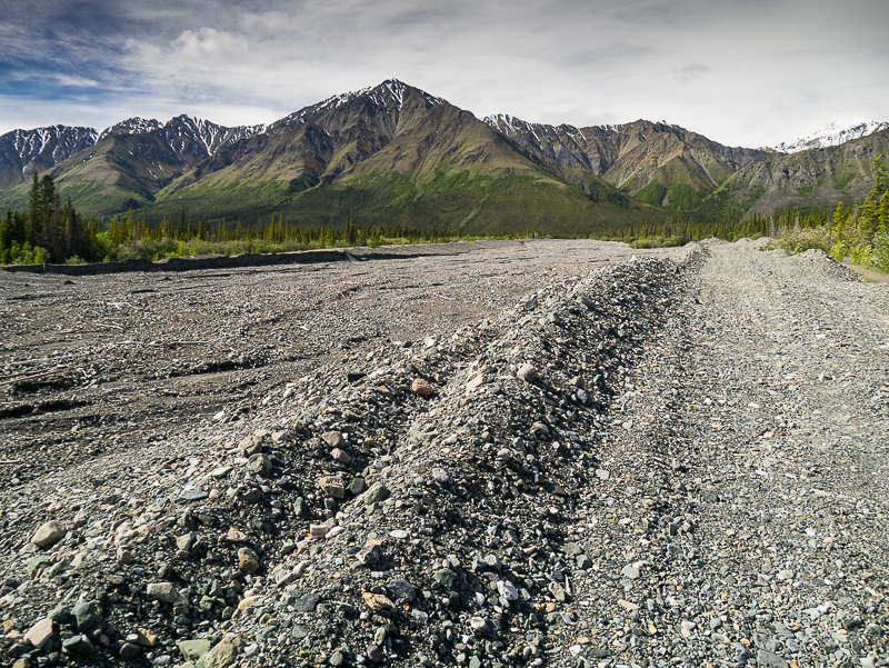
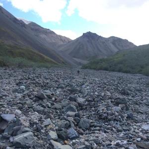
The route starts off on the north side of Bock's Creek along a road.
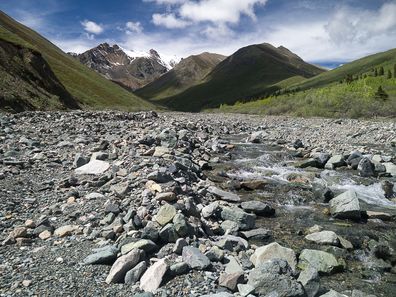
The creek bed is easy to follow up into the alpine.
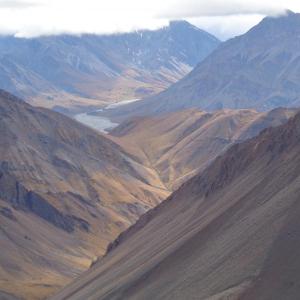
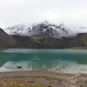
When you reach the alpine, look for the hill (left-center of photo). On the other side of this hill is Bock's Lake.
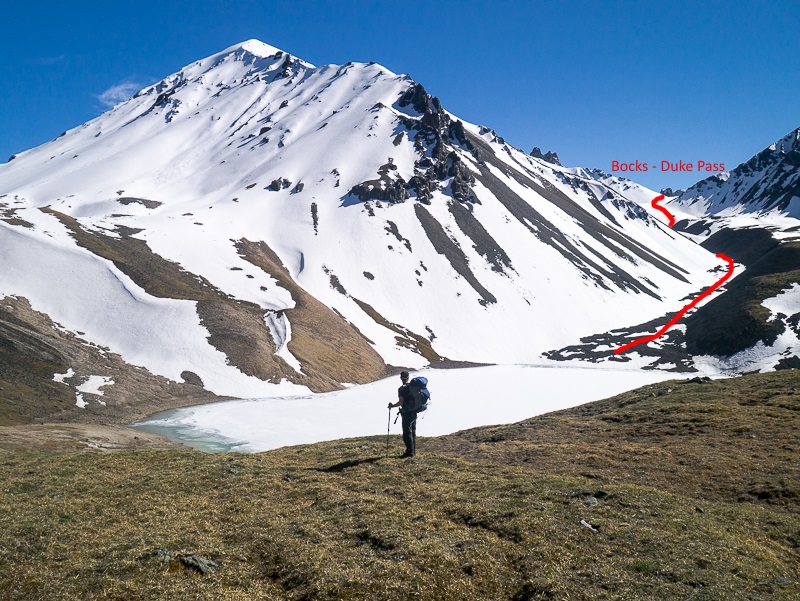
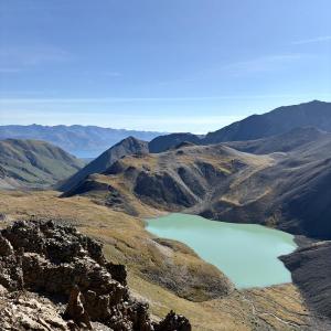
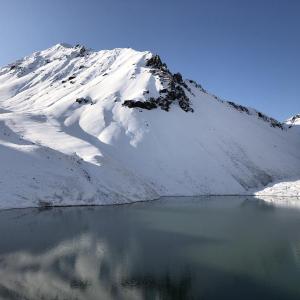
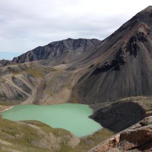
A frozen Bock's Lake, nestled in alpine. The Bock's - Duke pass is the route marked in this photo.
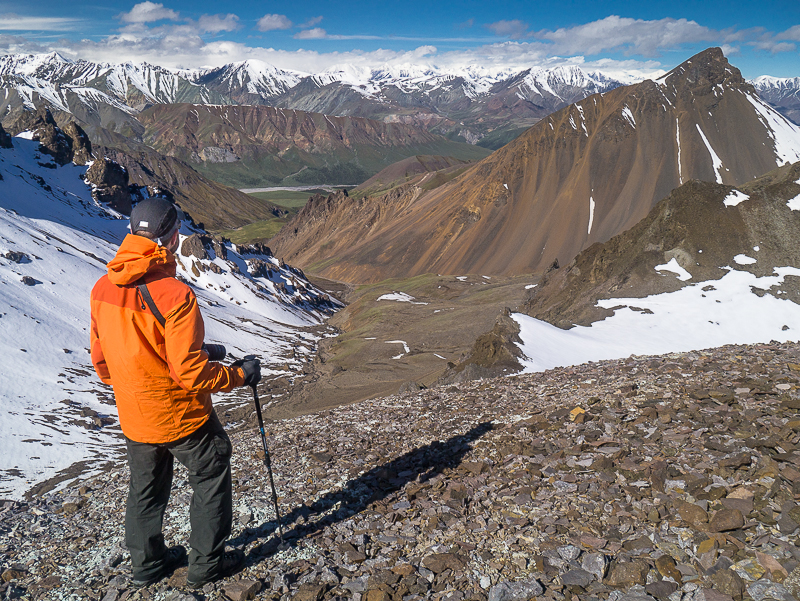
Looking down towards the Duke River from the Bock's - Duke pass.
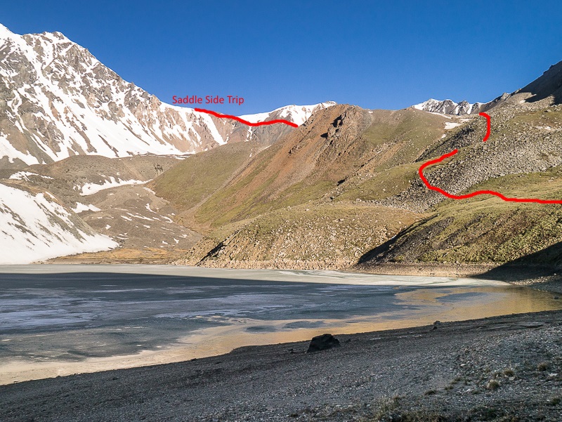
Looking up to one of the side trips from Bock's Lake. The route follows the ridge up to a saddle.
Looking back down over Bock's Lake from the saddle side trip. Kluane Lake is far in the distant top left of the photo.
The spectacular view from the side trip up to the saddle.

EC July 27, 2026
We did this hike on July 25-26. What a great trail! I followed someone's advice in the comments below to bring rubber tips for your hiking poles, and want to confirm that this was a great idea. My hiking partner didn't have any and found her poles to be much less useful on the rocky/boulder-y terrain. We got to enjoy the company of pikas, ground squirrels, and one noisy marmot :) Unfortunately we didn't have time for either of the side trips, but it's a perfect excuse to come back! Would highly recommend this hike if you just have a couple days to get outside.
Ree June 14, 2026
I went up on June 13 as a little exploratory day hike. The creek was low enough that there were no issues with access and I didn't need to cross. In Nine's Pass I encountered a medium-sized black bear a couple hundred metres in front of me - it immediately took off the other way. I decided the turn back there but will definitely be returning another time for the full hike!
Nissa August 24, 2025
Bocks Lake Aug 22-24!
4hr hike in (parked at 2.7km).
All the rocks! I recommend putting the little rubber feet on your hiking poles to better grip the rocks, I forgot mine and bailed many times. As others have said, just keep the creek on your left the whole way up.
5 mountain goats and as usual, tons of ground squirrels and marmots. No signs of any other wildlife. Musical rock slides across the lake, very cool! Definitely the coldest lake I've swam in a while.
Friday night, super quiet: only 1 other group of two. Saturday night: 13 people came between 5-7pm. Highly recommend going during the week or early on the weekend if you'd like the lake to yourself.
I attempted to do the saddle side trip, but got lost? I even downloaded the map and couldn't find the route. But was happy enough with the views from where I ended up.
TE July 20, 2025
Glorious 2 nights at Bock’s Lake. This is just a friendly reminder that this special spot is seeing more traffic, please hike waaaay up for toilet. Around camp we came across 2 toilet spots. Join the marmots and poop with a view!
DR July 7, 2025
Did this June 21-23 on a perfect warm sunny weekend. 2 nights there with the saddle hike on the middle day. BIG difference in the amount of ice on the lake on night 1 vs night 2.
Was able to drive a good 1-1.5km in from the road. It really is as simple as keeping the river on your left going up. The first 6km took under 2 hours, the last 5-6 took a little river 3 with breaks. The last 3km is the only real rough, chunky, loose rock, slow going section.
Only one real pinch section about 3km from the top as pictured. 2 or 3 spots where you’re forced up into the bush, but there are visible trails.
There were clean running water spots to fill up all the way up, so don’t worry about hauling too much water. Right before you climb the last hill there’s a nice creek and mini waterfall on the right where we filled up.
Camping at the lake is beautiful. No bear sign, but a ground squirrel chewed up a flip flop and a hole in the side of the tent to get at a ziplock. They were bold and hungry.
Can’t recommend the saddle side trip enough. Was left speechless. Was a bit of snow at the top, and we took the wrong route up, but if you follow the correct ridgeline up it’s fairly straightforward and SO worth it.
The wildflowers coming out while we were there were stunning. MASSIVE rockslides the whole time we were there on the slope SW of the lake. Super cool, sounded like thunder.
Legs (and feet from the rocks) were a bit sore, but it’s an awesome trip and fairly accessible
Shailyn September 23, 2024
My 4th time hiking to/camping at Bocks Lake. Hiked August 31 to Sept 2 (2 nights). Beautiful autumn colours. We were treated to quite the snowy day on the final day. It was cold and beautiful. Ran into a bear on our hike in (it was heading out of the forest to grab a drink at the creek - all good, bear doing what bears do). I think I have said it before, but this is a hike I spend two nights at, as the rocks are plentiful and my ankles like the day of rest(ish) in between.
JR July 15, 2024
12k almost exactly from the highway to the edge of Bock's Lake. Water levels made it easy to stay right the entire way up the creek bed; I think there were 3 times when we had to get up on to the bank/scramble through some brush but it's clear to see that others have done this before you. As per previous comments, walking on rocks for the entire way isn't exactly super fun but it also makes following the route pretty easy. The creek bed goes get 'rougher' as you climb (bigger rocks) and it was a relief to get to the green bits of the last 1-2 kms. I was expecting a more obvious 'right turn' between 9-10k but it was more like stay right, don't "turn" right. Once you are on the green, flatter area (~11k) it's clear to see the "hill" to the left, behind which is Bock's Lake.
The lake is glorious but it was super windy at night. I can imagine how quickly weather could change up here.
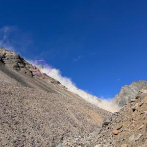
Our hike back down included a pretty scary rock slide at the narrowest part of the hike, around the 10k mark (from start). A massive chunk of rock broke off up high and crashed into the valley below where we had been only 10 minutes previous. No indication what caused it but am sharing here as kind of an FYI/heads up I guess for future hikers. This photo was taken right after the bolder hit the bottom - the dust being what it left in its wake.
Larra July 8, 2023
Love this route!! We hiked in as a large group of 13 over the July long weekend. Despite persistent rain on day one, the creek levels were such that we never needed to cross, but chose to at approx. 10km to claim a suitable basecamp on a large vegetated slope. Staying right the whole time makes for 'smooth' travel, as smooth as constant rock-walking can be. The lake was nearly free of ice and totally swimmable.
A pair of woman's prescription sunglasses were left behind at our basecamp (km 10). Tory Burch brand, large brown tortoise shell frames with slight prescription for distance. Please see photo. Please reply to this post if located. Thanks! Happy trails!
Shailyn June 29, 2023
Did my (now) annual hike to Bocks Lake on June 24-26th. The wildflowers were out of this world! The trail is completely snow free. We didn't do one of the day hike options since our group had some people with much less hiking experience, but it looked like those two day trips might have still had a bunch of snow on them. The hike to the lake and back was snow free. The lake was partially frozen still, but looks like it was melting fast. Rock, rocks, rocks, that's always the story of this hike. Good ankle support boots and hiking poles are a needed friend for sure. no signs of bears. Saw some marmot, pika and goat friends. The creek was pretty high. We didn't need to cross it, but on the way back it was getting closer to having to. Always one of my favourite hikes in the Yukon. Can't wait to go back!
Shailyn D September 7, 2022
Spent the September long weekend doing this hike again (September 3rd to 5th). My second time back here, but this time we made sure to stay for two nights at the lake. I highly recommend two nights, since hiking 22km of that non-stop creek bed rock can be tough, so having a day in between to space that out will make your ankles happier. And the day hikes from the lake are truly incredible. We went up the right saddle and had spectacular views of the river valley and icefield mountains. The autumn colours were out of this world. The first night had amazing aurora, the second night had lovely snow (snow blanketed or tents and all the surrounding land. Truly beautiful. No signs of bear. Lots of pikas, a screaming marmot and some ptarmigan. The creek was much higher on the way back (because of the snowmelt), which caused us to have to be more cautious with some of the scrambles around the creek. This is easily one of my favourite hikes and I can't wait to go back.
Marie-Soleil August 20, 2022
Amazing backpacking trip! Bock’s lake is magnificent and the side trips are a must. But if you have to choose, do the Saddle. On a clear say, you can see Mount Logan.
Tom August 8, 2022
As of July 2022, gravel road is washed out within about 300m of the highway.
Heather Swystun August 8, 2021
Found hiking poles at trailhead. Pm me on Facebook. Stay right avoid high water or rain events. Fabulous side hikes a must.
Liz B August 2, 2021
A group of 4 of us hiked Bocks on July 31/Aug 1. We were able to cut off some hiking distance by driving 2km up the gravel road (there was heavy equipment running and we made sure to ask for permission from them before parking where we did).
The water level in the creek was low enough that we were able to stick to the right hand side of the creek the entire way up without crossing. There are 2 spots where you have to climb up the hillside to continue along the right hand side of the creek, we tried leaving some rock piles to show where those trails began. The trails are visible and worn down, easy to find if you pay attention.
Like the commentor below mentioned, I can see how people might get confused by the "vegetated islands" cue. Right before you climb the final hill to get to the lake there are two small "vegetated islands", they are well past where the valley Y's. Don't try crossing the creek to go up any other ones you see.
We made it to the lake in just under 6 hours (including a few breaks). Set up our tents and decided to continue hiking up to the saddle. I 100% recommend this if you have clear skies because the views into the icefields were absolutely incredible! Our Garmin told us this saddle side hike was 6.5kms (return distance) with an elevation gain of about 500m. It took us around 2.5 hours to get up and 2 to get back to the lake.
This hike is basically all rock walking so be prepared with good footwear. Most of our group had pretty sore feet by the time we got back to our vehicles.
We had 3 dogs in our group and none of them had issues making it through the hike.
We saw some sheep, ground squirrels, pikas, a golden eagle and 2 grizzlies (very far off in the Duke River valley) and we heard a few marmots.
Another group of 9 people showed up to camp at the lake in the afternoon and on our hike out we passed 2 groups of people, about 13 individuals in total. It seems like it's becoming a busier hike so be prepared to share the lake with other folks, especially if the weather is nice.
KP July 28, 2021
Friends and I did this trail July 24-25, 2021. We found the instructions for the route to be a bit confusing, so I wanted to make a comment to hopefully save others from the confusion. We had very low water levels when we went, so we were able to stick to the right of the creek the whole time and didn't have to do any creek crossings. There are a few sections where the creek comes right to the side of the valley where you have to climb up some rocks or hike up a small trail to pass it, but it wasn't bad. Despite what other commenters have said, I brought my husky mix on this hike and he had a blast, although he is very used to challenging hikes and is very nimble, I brought back up booties for his feet incase his feet were sore from the rocks, but we didn't end up needing them.
Clarification on the route description: When the water levels are low, you can follow the creek on the right side. There are a few creeks that flow into Bock creek, do not confuse these with the creek splitting. You will come to a spot where there are two large valleys coming together to make a Y, this is the part the instructions were referring about a split - "After roughly 10 km, the creek route looks like it starts to split. You want to follow the creek to your right." There's a hill with a strip of vegetation on it in the middle of the Y here. Do not climb this hill, just continue along the right of the creek and keep following it until you find sections of the valley that are covered in grass - these are the vegetation islands. Keep walking straight through the valley until it ends, and you will see a grassy mound with a trail going diagonally through it to the top left of it. This is the final hill and Bock Lake is on the other side.
MO August 9, 2020
Did the trail Aug 6-8. Absolutely gorgeous trip with amazing views the whole way. We saw goats, sheep, pikas, and marmots.
This trail was not what we were expecting from the description however. It might be because it was a high water year, but there are definitely a few scrambles up on some steeper rocks to make it through. I would not recommend bringing dogs. There were a couple spots where we had to lift the dogs up onto rocks, have them stay, scramble up ourselves, then lift them down. Not easy with big dogs! The rocks are also quite sharp so took a toll on the pads of their paws. You are only hiking or vegetation for about the last 200 metres.
Incredibly beautiful though!
MC July 20, 2020
Hiked this July 17 to 19 2020. The creek was high and the current very strong. As said in other comments, it is possible to stay right of the creek the entire way up and I strongly advise you to do so. After 4 km, it starts to seem impassable but stay right. We did cross there because the left side seemed easier but it was actually a big mistake. There are lots of rocks moving fast in the water and one of them hit me hard on the ankle. I just ended up with a bruise, but it could have been much worse. On the left side, we had to bushwhack on slippery slopes and scramble over the fast water of the creek. One of my friends received a big rock on his hand when scrambling the crumbly rock. We finally ended up having to cross again in a crazy strong current because of an impassable canyon. We did not enjoy that at all. Water was waist high and very strong. Back on the right side, the final stretch was pretty easy. On our way back down, we stayed on the right side (well, left when you descend) and it was smooth all the way with some quite easy bushwhacking.
Overall, it was an incredible trip and it is worth staying for at least one night and take the side trips and enjoy the change of light on the lake and the surrounding mountains. I am still amazed by the beauty of that place. We saw dall sheeps and we were witness of a very strong and impressive rock avalanche behind the lake.
The saddle trip on the right is accessible with some snow at the end, about knee deep, but it should be passable if it's not too hot and under the sun.
Side note : please remember not to throw any organic garbage in the nature that can't be naturally found there. There were some apple cores and egg shells at a view point. Please leave no trace! Respect the natural balance of the place that you are visiting and respect the hikers that are following you and are not really interested to know what you had for lunch. We all love to find ourselves immersed in an untouched wilderness. Thanks!
Michelle May 19, 2020
Hiked this on the may public holiday weeekend. Did quite a few creek crossings on the way up and less on the way down, some still had frozen sections we could walk across. A lot of snow up top which was pretty wet. We brought snowshoes for the last part to the lake but a beautiful area. Our plan was to continue through to congdon creek but weather prevented us. Next time!
JCM August 25, 2019
Hiked Bock's this weekend (Aug 24-25). Wonderful trip up. The road was not in good enough condition for my small car to make it far at all. We started basically at the highway. My main recommendation is to try to stay on the right side of the creek if possible to avoid crossing the back and forth. We were able to make it up without crossing (but in one section we had to walk in about an inch of water along the side to avoid crossing).
There was snow when we reached the top and it snowed overnight some more (~10cm!). Unfortunately either of the side trips would have had a bit too much snow for what we were prepared for.
Rhiannon August 6, 2019
Hiked this last weekend. Twice we thought a vegetated hillside along the creek bed was THE vegetated hillside described above. So we did some unnecessary climbing and ended up camping one night before making it to the lake. Then spent the second night at the lake.
There’s now a trail worn in the hill the lake is behind. You can follow that up and cut out some unnecessary walking on the rocky creek bed.
Views were beautiful. FYI the creek was high and fast in spots, so bring Crocs/shoes for crossing. Though there are some worn semi-trails in the bank, so you can hike/bushwhack around and avoid crossing. We saw several sheep, as well as a grizzly and cubs far off on a hillside.
Lost Shirt September 7, 2018
I forgot to mention I live in Whitehorse.
Lost Shirt September 7, 2018
Went September 2nd. Left September 4th.
I left my base layer at the trailhead. If anyone is going, please pick it up and let me know. It's located where there's a pull out for two cars (about 2 kilometers in, before Bocks Creek). Sitting on a rock on the left side (facing the creek). I recommend driving in a parking here. Saves some time.
It snowed the first night. Very beautiful location. Did the side hike where we had a view of the Donjek Range from around 2400 meters. Clear day. Awesome view. Bring gaitors because it's all snow at higher elevations (this time of year).
In terms of getting in, stay right of the creek for the first part. You'll see a point where if you were left, you wouldn't be able to get around a steep drop off. After this drop off point, cross the creek and stay left. It's much easier. I tried to score an arrow on a large rock there so I'm not sure if it will hold up. I stayed right the whole way in until I couldn't and it wasn't as friendly. Stay left until the water disappears and you see a large, steep slope in the middle (drop off on either side of the slope). Go up it. It's just after you cross the creek from the left side. Only one creek crossing required (this time of year) with sandals or similar. You can hop rocks near the end of the creek (where you still see it).
FrozenFella August 7, 2018
We did this hike a few years ago and enjoyed the hike up and back although it's all in a narrow valley until the lake. Personally I still thought the views along the way were spectacular. I would call this a moderate hike, mainly due to the large rocks and boulders that cover much of the valley floor. It took us about six hours up, and we just crossed the creek as necessary rather than trying to create new trails along the hillsides and through the brush. Take along some creek shoes such as crocs or sandals. I would suggest good supportive boots with a solid sole to prevent rock bruising, and although I saw people up there with dogs, I wouldn't take my husky...to much risk on that kind of terrain.
We saw eighteen people on our way up and back, which is way more traffic than I'm used to in the Yukon.
Holger July 15, 2018
We did the hike 4 weeks ago didnt see any bears but be aware of the sqhirrels they ate my girlfriends bra ... the hike itself is to be honest exausting cause you basically walking on rocks all the time. The other thing is that you also not seeing anything interesting cause you're in the valley the whole way up ... don't get me wrong the view up there is amazing and its beautiful and super remote to camp there but you have to choose if its worth it to hike for like 5-6 hours on rocks
Josee Leclerc September 9, 2017
We hiked this trail over 3 days. The south and west trail from the lake is definitely the highlight. Beautiful at the end of August.
Glenda July 28, 2017
The lake is lovely with many adorable pikas and marmots. The alpine hiking beyond the lake is not to be missed. Here are our notes:
1. Drive as far as you can up the road. It will save you 1.8 kms of fairly boring walking.
2. Stay to the right hand side of the creek when ascending. Detour up into the bushes where the creek seems impassable, but don't be tempted to cross over to the left side because you'll just have to cross back due to rock faces.
3. Although the lake is lovely, I don't recommend this for a day hike because it's 10 kms of uneven footing with not much scenery just to get up to the lake. Once you get to the lake, it's worth doing at least one side trip to see the big mountains. You'll have time to do this on a two-day trip.
4. The immediate area around the lake is starting to show slight signs of wear, so try to spread out around the lake when camping. There are some bold ground squirrels that have clearly been fed, so keep your food secure and don't reward them. The area is clearly popular--there were 5 groups of campers on one of our nights--so be sure to leave no trace. http://www.leavenotrace.ca/principles
Emily July 18, 2017
Such an awesome spot! We did this hike during the first week of July and we had the most beautiful weather, there were no bugs and we didn't see any bears. It was great. It took us 5.5 hours up with gear for 2 nights, and about 3.5 hours out. The last 2 k of the hike up gets pretty tough.
Susannah May 22, 2017
Trail is mostly snow free all the way to the lake. Around the lake itself there is a lot of snow so we camped before the lake to the west where it was snow free and we had a beautiful view of kluane lake.
The day hike to the west is clear of snow. The one to the south is still completely snow covered.
Saw bear tracks at the beginning of the trail but no signs of bears near the lake.
Parked about 500m up the mining road to the left. A very curious bear paid a visit to our car while we were up the mountain, leaving its prints all over the hood and windshield. So park at your own risk.
Chelsea August 15, 2016
We did the hike August 5-7 -- amazing weather, gorgeous hike. The way in was rocky, but fairly straightforward. Well worth spending two nights on the lake. We did the saddle day trip and saw lots of sheep.
It took us 6.5 hours in and about 4.5 out. Bear traces on the way in, but didn't notice anything up by the lake.
We had a GPS with us and found it useful -- I could see how it might be difficult to find the lake.
Highly recommended!
Pippa & Lawrence July 26, 2016
meant to add:
It took us 6 hours up and 4.5 down.
Pippa & Lawrence July 26, 2016
Nice hike! We backpacked in July 22nd and came out next day as it was socked in and raining. Saw grizzly bear and flock of sheep up top. Took GPS and topo map which helped us find the route in the upper section. Rather than "islands of vegetation", I would say that as you climb higher you increasingly have a choice between the rocky valley bottom and vegetated side-hills. Each has its pros and cons. We were able to keep our feet dry by sticking to the right side of the valley (heading up) and side-hilling/bushwhacking where necessary when the main creek flowed up against that side of the valley (following routes that others had obviously taken). Side-creeks were easy to step across. Maybe low water? This hike could be called "Bock's Rocks" - it's tough on canine paws and a challenge for those who prefer solid, even footing.
Kathie September 18, 2015
This is one of my favorite hikes. Really enjoyed it. It's not easy, but great views. Highly recommend it. Also was super quiet.
Taywada August 3, 2015
Just did the hike and didn't find the lake:( it was beautiful none the less! Smart to bring a gps or a topo map. Talked to the people at the visitors center and there have been those who had a hard time finding it in the past. The description on this site is vague. There is "green vegetation" the whole time. The "creek" crossings are also unpredictable and change quickly. We had a true adventure and loved the country regardless. Not sure who writes these descriptions but not the first time a hike has been hard to find according to this site.
LJ August 1, 2015
Had a wet, rainy hike up for a night this week. Prepare for mountain weather up there, we woke up to snow in the peaks.
Prepare for a long day up! Took our energetic group 7 hrs up, felt longer than 12 km. Only 4.5 hrs down. Doubled our # of creek crossings on the way down with all the run-off (rain).
Options to camp before reaching the lake. At ~11 km?, right after you the narrowest ascent of hike there is a green vegetated plateau, access to creek).
Gorgeous country.
Terry Joss August 26, 2014
My new favorite hike. Took about 7.5 hours to go to the lake and back, wish I was able to stay the night and explore. Definitely can get some good mtn weather up there and fast so be aware of that. Easy hike, long hike though and on uneven ground. Highly recommend this hike to everyone.
Karl McEwan August 16, 2014
Decided to try it as a day hike and had a great time. 6 and a half hours to the saddle west of the lake, a beautiful view into Kluane and a few sheep in the rocks below us. Then 5 hours back to the car parked at the Highway. The creek was relatively low so we managed to pick our way across without taking our boots off and the light packs made the ~30km day do able.